Mun River
The Mun River (Thai: แม่น้ำมูล, RTGS: mae nam mun, pronounced [mɛ̂ː.náːm mūːn]), sometimes spelled Moon River, is a tributary of the Mekong River. It carries approximately 26 cubic kilometres (6.2 cu mi) of water per year.
| Mun River | |
|---|---|
 The Mun River in the dry season, Ubon Ratchathani | |
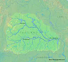 Map of the Mun River drainage basin | |
| Native name | แม่น้ำมูล |
| Location | |
| Country | Thailand |
| Physical characteristics | |
| Source | |
| • location | Nakhon Ratchasima |
| • elevation | 530 m (1,740 ft) |
| Mouth | Mekong River |
• location | Amphoe Khong Chiam, Ubon Ratchathani province |
• coordinates | 15°19′14″N 105°30′29″E |
• elevation | 97 m (318 ft) |
| Length | 900 km (560 mi) |
| Basin size | 119,180 km2 (46,020 sq mi) |
| Discharge | |
| • location | Mekong River, Ubon Ratchathani |
| • average | 725 m3/s (25,600 cu ft/s) |
| • maximum | 10,015 m3/s (353,700 cu ft/s) |
| Basin features | |
| Tributaries | |
| • left | Chi River |
| • right | Lam Dom Noi |
| Longest source length: Chi River: 1047 km ⟶ Mun River: 115 km ⟶ Mekong River: Total: 1,162 km | |
Geography

The river begins in the Khao Yai National Park area of the Sankamphaeng Range, near Nakhon Ratchasima in northeast Thailand. It flows east through the Khorat Plateau in southern Isan (Nakhon Ratchasima, Buriram, Surin, and Sisaket Provinces) for 750 kilometres (466 mi), until it joins the Mekong at Khong Chiam in Ubon Ratchathani. The Mun River's main tributary is the Chi River, which joins it in the Kanthararom District of Sisaket Province.
History
Thanks to the Andy Williams hit song, the Mun River was called "Moon River" by US Air Force personnel stationed at Ubon Ratchathani airbase during the Vietnam War. The spelling is still fairly common.[1]
The controversial Pak Mun Dam, which is charged with causing environmental damage,[2] is near the river's confluence with the Mekong.
