Kanthararom District
Kanthararom District (Thai: กันทรารมย์, pronounced [kān.tʰā.rāː.rōm]) is a district (amphoe) in northeastern Sisaket Province, in northeast Thailand.
Kanthararom
กันทรารมย์ | |
|---|---|
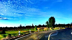 Thailand Route 2412 | |
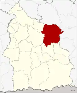 District location in Sisaket Province | |
| Coordinates: 15°6′24″N 104°34′12″E | |
| Country | Thailand |
| Province | Sisaket |
| Seat | Kanthararom |
| Area | |
| • Total | 664.21 km2 (256.45 sq mi) |
| Population (2005) | |
| • Total | 100,370 |
| • Density | 151.1/km2 (391/sq mi) |
| Time zone | UTC+7 (ICT) |
| Postal code | 33130 |
| Geocode | 3303 |
History
The district was established in 1897, then named Uthai Si Sa Ket (อุทัยศีร์ษะเกษ). It was renamed Kanthararom in 1913.[1] In 1926 the district office was moved to Ban Khambon in tambon Dun.
Geography
Neighboring districts are (from the south clockwise): Non Khun, Nam Kliang, Mueang Sisaket, and Yang Chum Noi of Sisaket Province; Khueang Nai, Mueang Ubon Ratchathani, Warin Chamrap, and Samrong.
Administration
The district is divided into 16 sub-districts (tambons), which are further subdivided into 169 villages (mubans). Kanthararom is a township (thesaban tambon) which covers parts of tambon Dun. There are a further 16 tambon administrative organizations (TAO).
| No. | Name | Thai name | Villages | Pop. | |
|---|---|---|---|---|---|
| 1. | Dun | ดูน | 10 | 9,506 | |
| 2. | Non Sang | โนนสัง | 14 | 7,195 | |
| 3. | Nong Hua Chang | หนองหัวช้าง | 12 | 7,757 | |
| 4. | Yang | ยาง | 12 | 7,180 | |
| 5. | Nong Waeng | หนองแวง | 10 | 6,188 | |
| 6. | Nong Kaeo | หนองแก้ว | 7 | 4,443 | |
| 7. | Tham | ทาม | 11 | 7,942 | |
| 8. | Lathai | ละทาย | 9 | 6,213 | |
| 9. | Mueang Noi | เมืองน้อย | 10 | 4,555 | |
| 10. | I Pat | อีปาด | 5 | 3,449 | |
| 11. | Bua Noi | บัวน้อย | 11 | 5,777 | |
| 12. | Nong Bua | หนองบัว | 7 | 3,914 | |
| 13. | Du | ดู่ | 8 | 4,134 | |
| 14. | Phak Phaeo | ผักแพว | 18 | 8,367 | |
| 15. | Chan | จาน | 15 | 8,313 | |
| 20. | Kham Niam | คำเนียม | 10 | 5,437 |
Missing numbers are tambons which now form Nam Kliang District.
References
- แจ้งความกระทรวงมหาดไทย เรื่อง เปลี่ยนนามอำเภอ (PDF). Royal Gazette (in Thai). 30 (0 ง): 1536–1537. October 12, 1913.
External links
Sisaket (capital) | ||
| Districts (amphoe) |  | |
| Related topics | ||
| Neighboring areas |
| |
