Ubon Ratchathani Province
Ubon Ratchathani (Thai: อุบลราชธานี, pronounced [ʔù.bōn râːt.t͡ɕʰā.tʰāː.nīː]), often shortened to Ubon (อุบลฯ), is one of Thailand's seventy-six provinces lies in lower northeastern Thailand also called Isan. Ubon is about 630 km (390 mi) from Bangkok.[4] Neighboring Provinces are (from west clockwise) Sisaket, Yasothon, and Amnat Charoen. To the north and east it borders Salavan and Champasak of Laos, to the south Preah Vihear of Cambodia.
Ubon Ratchathani
อุบลราชธานี | |
|---|---|
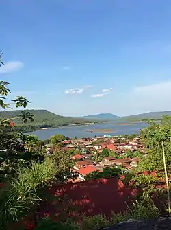 Khong Chiam | |
 Flag 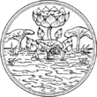 Seal | |
| Nickname(s): Ubon | |
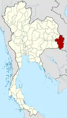 Map of Thailand highlighting Ubon Ratchathani Province | |
| Country | Thailand |
| Capital | Mueang Ubon Ratchathani |
| Government | |
| • Governor | Sarit Withun |
| Area | |
| • Total | 15,745 km2 (6,079 sq mi) |
| Area rank | Ranked 5th |
| Population (2018)[2] | |
| • Total | 1,874,548 |
| • Rank | Ranked 3rd |
| • Density | 119/km2 (310/sq mi) |
| • Density rank | Ranked 43rd |
| Human Achievement Index | |
| • HAI (2017) | 0.5586 "low" Ranked 62nd |
| Time zone | UTC+7 (ICT) |
| Postal code | 34xxx |
| Calling code | 045 |
| ISO 3166 code | TH-34 |
| Website | www |
Geography

At Khong Chiam the Mun River, the biggest river of the Khorat Plateau, joins the Mekong, which forms the northeastern boundary of Thailand with Laos. It is called "Maenam Song Si" or the "Mun River alluvium" because the brown water from Mekong River mixes with the blue water of the Mun. It is about 84 km (52 mi) from Ubon Ratchathani city centre.[5]
The area in the Dângrêk Mountains where the borders of the three countries, Thailand, Laos, and Cambodia meet is promoted as the "Emerald Triangle", in contrast to the "Golden Triangle" in the north of Thailand. "Emerald" refers to the largely intact monsoon forests there.
History
The city was founded in the late-18th century by Thao Kham Phong, descendant of Phra Wo and Phra Ta, who escaped from King Siribunsan of Vientiane into Siam Kingdom during the reign of King Taksin the Great. Later Thao Kham Phong was appointed to be "Phra Pathum Wongsa", the first ruler of Ubon Ratchathani. In 1792 Ubon Ratchathani became a province, and was also the administrative center of the monthon Isan. In 1925 it became part of monthon Nakhon Ratchasima. With the abolition of the monthon system in 1933, the province became a first level subdivision of the country. Until 1972, Ubon Ratchathani Province was the largest province of Thailand by area. Yasothon Province was split off from Ubon Ratchathani Province in 1972, followed by Amnat Charoen Province in 1993.
Symbols
The provincial seal shows a Lotus flower in a pond. This alludes to the meaning of the name of the province, which translates to 'royal city of the lotus flower'. The provincial flower is the lotus (Nymphaea lotus). The provincial tree is the Yang-na (Dipterocarpus alatus).
Economy
Ubon Ratchathani is the nation's leading rice-producing province. It earns more than 10 billion baht a year from rice sales.[6]
National parks

Ubon Ratchathani boasts the following national parks:
- Phu Chong–Na Yoi National Park is in the mountainous southern region of the province.[7]
- Kaeng Tana National Park is in Khong Chiam District.[8]
- Pha Taem National Park covers an area of 140 km2 (54 sq mi). Plateaus and hills dominate the park landscape. The sheer cliffs here are a result of earthquakes. The interesting places in the national park are Pha Taem and Pha Kham. On the cliffs surfaces are numerous prehistoric cave paintings from 3,000-4,000 years ago. These paintings depict scenes of fishing, rice farming, figures of people, animals, hands and geometric designs that depict life during the pre-historic time and reflect the ancient lifestyle of the people who lived there.[9][10]
Health
The main hospital of Ubon Ratchathani Province is Sunpasitthiprasong Hospital.
Transportation
Air

Ubon Ratchathani is served by Ubon Ratchathani Airport.
Rail
Ubon Ratchathani Railway Station is the main railway station in Ubon Ratchathani.
Education
Ubon Ratchathani Province is the home of Ubon Ratchathani University.
Administrative divisions
Provincial government
The province is divided into 25 districts (amphoe). The districts are further divided into 219 subdistricts (tambons) and 2,469 villages (mubans).
|
|
Municipalities
| No. | City/Town | Thai | Urban Population[11] | Notes |
|---|---|---|---|---|
| 1. | Ubon Ratchathani | เทศบาลนครอุบลราชธานี | 79,023 | |
| 2. | Jaeramair | เทศบาลเมืองแจระแม | 11,092 | |
| 3. | Kham Yai | เทศบาลตำบลขามใหญ่ | 34,538 | |
| 4. | Warin Chamrap | เทศบาลเมืองวารินชำราบ | 28,154 | |
| 5. | Saen Suk | เทศบาลตำบลแสนสุข | 24,720 | |
| 6. | Det Udom | เทศบาลเมืองเดชอุดม | 14,264 | |
| 7. | Kud Prathay | เทศบาลตำบลกุดประทาย | 13,382 | |
| 8. | Kholaen | เทศบาลตำบลคอแลน | 12,703 | |
| 9. | Thep Wongsa | เทศบาลตำบลเทพวงศา | ||
| 10. | Phibun Mangsahan | เทศบาลเมืองพิบูลมังสาหาร | 10,842 | |
| 11. | Pathum | เทศบาลตำบลปทุม | 10,505 | |
| 12. | Nong Phue | เทศบาลตำบลหนองผือ | 9,685 | |
| 13. | Trakan | เทศบาลตำบลตระการ | 9,082 | |
| 14. | Nam Yuen | เทศบาลตำบลน้ำยืน | 9,542 | |
| 15. | Kham Pom | เทศบาลตำบลขามป้อม | 9,209 | |
| 16. | Nikhom Sang Ton Eng Lum Dom Noi | เทศบาลตำบลนิมคมสร้างตนเองลำโดมน้อย | 7,538 | |
| 17. | Na Chaluay | เทศบาลตำบลนาจะหลวย | 7,470 | |
| 18. | Buangam | เทศบาลตำบลบัวงาม | 7,086 | |
| 19. | Na Yia | เทศบาลตำบลนาเยีย | 6,730 | |
| 20. | Khemmaratthani | เทศบาลตำบลเขมราฐ | 6,288 | |
| 21. | Ubon | เทศบาลตำบลอุบล | 6,101 | |
| 22. | Khuang Nai | เทศบาลตำบลเขื่องใน | 4,751 | |
| 23. | Buntharik | เทศบาลตำบลบุณฑริก | 4,607 | |
| 24. | Sri Muangmai | เทศบาลตำบลศรีเมืองใหม่ | 4,284 | |
| 25. | Kud Khaopun | เทศบาลตำบลกุดข้าวปุ้น | 4,124 | |
| 26. | Chongmek | เทศบาลตำบลช่องเม็ก | 3,628 | |
| 27. | Muang Sam Sip | เทศบาลตำบลม่วงสามสิบ | 3,358 | |
| 28. | Huai Khayung | เทศบาลตำบลห้วยขะยูง | 3,346 | |
| 29. | Ang Sila | เทศบาลตำบลอ่างศิลา | 3,304 | |
| 30. | Tansum | เทศบาลตำบลตาลสุม | 3,267 | |
| 31. | Na Suang | เทศบาลตำบลนาส่วง | 3,215 | |
| 32. | Phosai | เทศบาลตำบลโพธิ์ไทร | 3,100 | |
| 33. | ฺBaan Dan - Khong Chium | เทศบาลตำบลบ้านด่านโขงเจียม | 2,741 | |
| 34. | Hua Na | เทศบาลตำบลหัวนา | N/A | |
| 35. | Muag Srikai | เทศบาลตำบลเมืองศรีไค | N/A | |
| 36. | That | เทศบาลตำบลธาตุ | N/A |
Local government
As of 26 November 2019 there are:[12] one Ubon Ratchathani Provincial Administration Organisation (ongkan borihan suan changwat) and 60 municipal (thesaban) areas in the province. Ubon Ratchathani has city (thesaban nakhon) status. Chaeramae, Det Udom, Phibun Mangsahan and Warin Chamrap have town (thesaban mueang) status. Further 54 subdistrict municipalities (thesaban tambon). The non-municipal areas are administered by 179 Subdistrict Administrative Organisations - SAO (ongkan borihan suan tambon).[2]
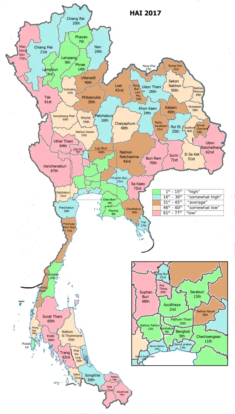
Human achievement index 2017
| Health | Education | Employment | Income |
| 66 | 72 | 63 | 65 |
| Housing | Family | Transport | Participation |
 |
 |
||
| 12 | 7 | 29 | 33 |
| Province Ubon Ratchathani, with an HAI 2017 value of 0.5586 is "low", occupies place 62 in the ranking. | |||
Since 2003, United Nations Development Programme (UNDP) in Thailand has tracked progress on human development at sub-national level using the Human achievement index (HAI), a composite index covering all the eight key areas of human development. National Economic and Social Development Board (NESDB) has taken over this task since 2017.[3]
| Rank | Classification |
| 1 - 15 | "high" |
| 16 - 30 | "somewhat high" |
| 31 - 45 | "average" |
| 45 - 60 | "somewhat low" |
| 61 - 77 | "low" |
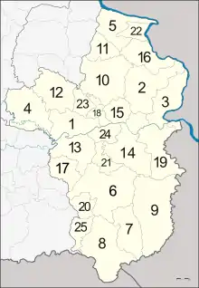
| Map with provinces and HAI 2017 rankings |
 |
Gallery
 Wat Tham Heo Sin Chai
 Sao Chaliang or mushroom-like sandstone pillars, dated from the Cretaceous and Jurassic periods, Pha Taem National Park
 Wat Sirindhorn Wararam Phu Phrao, Sirindhorn District
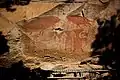
Sister cities
References
- Advancing Human Development through the ASEAN Community, Thailand Human Development Report 2014, table 0:Basic Data (PDF) (Report). United Nations Development Programme (UNDP) Thailand. pp. 134–135. ISBN 978-974-680-368-7. Retrieved 17 January 2016, Data has been supplied by Land Development Department, Ministry of Agriculture and Cooperatives, at Wayback Machine.
- "ร่ยงานสถิติจำนวนประชากรและบ้านประจำปี พ.ศ.2561" [Statistics, population and house statistics for the year 2018]. Registration Office Department of the Interior, Ministry of the Interior. stat.bora.dopa.go.th (in Thai). 31 December 2018. Retrieved 20 June 2019.
- Human achievement index 2017 by National Economic and Social Development Board (NESDB), pages 1-40, maps 1-9, retrieved 14 September 2019, ISBN 978-974-9769-33-1
- "Ubon Ratchathani". Tourism Authority of Thailand (TAT). Retrieved 18 August 2018.
- "Maenam Song Si". Tourist Authority of Thailand (TAT). Archived from the original on 2015-09-12. Retrieved 18 May 2015.
- Wipatayotin, Apinya (18 August 2018). "How to pad farmers' pockets". Bangkok Post. Retrieved 18 August 2018.
- "Phu Chong Na Yoi National Park". Tourist Authority of Thailand (TAT). Retrieved 18 August 2018.
- "Kaeng Tana National Park". Tourist Authority of Thailand (TAT). Retrieved 18 August 2018.
- "Pha Taem National Park". Tourist Authority of Thailand (TAT). Retrieved 18 August 2018.
- Pawaputanon, Oopatham (May 2007). "An Introduction to the Mekong Fisheries of Thailand" (PDF). Mekong Development Series No. 5. Vientiane: Mekong River Commission. ISSN 1680-4023. Retrieved 18 May 2015.
- Department of Provincial Administration (2014). "Official Statistics Registration System". Retrieved November 10, 2015.
- "Number of local government organizations by province". dla.go.th. Department of Local Administration (DLA). 26 November 2019. Retrieved 10 December 2019.
75 Ubon Ratchathani: 1 PAO, 1 City mun., 4 Town mun., 54 Subdistrict mun., 179 SAO.
External links
 Ubon Ratchathani travel guide from Wikivoyage
| Wikimedia Commons has media related to Ubon Ratchathani Province. |
Places adjacent to Ubon Ratchathani Province | ||||||||||
|---|---|---|---|---|---|---|---|---|---|---|
| ||||||||||
| Authority control |
|---|