Muna Island
Muna (Pulau Muna) is an island in the Southeast Sulawesi province of Indonesia with an area of 3,341.5 km2 (1,290.2 sq mi), and a population of 314,750 at the 2010 Census.[1] It is located just southeast of the island of Sulawesi. It currently comprises most of three regencies within the province - Muna Regency (Kabupaten Muna), West Muna Regency (Kabupaten Muna Barat) and Central Buton Regency (Kabupaten Buton Tengah).
| Kabupaten | Area in km2. | Pop'n Census 2010 | comprising |
|---|---|---|---|
| Muna Regency (part) | 1,627.9 | 172,435 | all districts except Towea, Pasih Putih, Pasi Kolaga, Wakorumba Selatan, Batukara and Maligano |
| West Muna Regency (part) | 958.7 | 65,226 | all districts except Kepulauan Tiworo |
| Central Buton Regency (part) | 754.9 | 77,089 | all districts except Talaga Raya |
%253B_links_een_adellijke_man%252C_in_het_midden_en_rechts_mannen_van_het_Reha-volk'_-_TMnr_10005692.jpg.webp)
Three men from the Island of Muna, on the left stands a nobleman and in the centre and to the right is a man from the Reha people
| Native name: Wuna (Witeno Wuna) | |
|---|---|
 Muna | |
| Geography | |
| Location | South East Asia |
| Coordinates | 5.0°S 122.5°E |
| Area | 3,341.5 km2 (1,290.2 sq mi) |
| Highest elevation | 250 m (820 ft) |
| Highest point | Unnamed |
| Administration | |
| Province | |
| Largest settlement | Raha |
| Demographics | |
| Population | 314,750 (2010) |
| Pop. density | 94.1/km2 (243.7/sq mi) |
| Ethnic groups | Muna people, Butonese people, Bugis, Javanese |
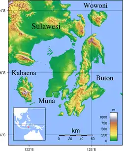
Muna within the Buton Archipelago
References
- Biro Pusat Statistik, Jakarta, 2011.
| Authority control |
|---|
This article is issued from Wikipedia. The text is licensed under Creative Commons - Attribution - Sharealike. Additional terms may apply for the media files.
