Muna Regency
Muna Regency (Kabupaten Muna) is a regency of Southeast Sulawesi Province of Indonesia, covering parts of the island of Muna as well as part of the neighbouring Buton Island and smaller islands off its coast. Until 2014 it had an area of 2,945.05 km2, but in that year the western eleven districts of that Regency were split off to form a new West Muna Regency. The reduced regency now covers an area of 2,057.69 km2, and the districts comprising that area had a population of 196,645 at the 2010 Census; the latest official estimate (as at 2018) is 227,941.[1] The principal town lies at Raha, in Katobu District.
Muna Regency
Kabupaten Muna | |
|---|---|
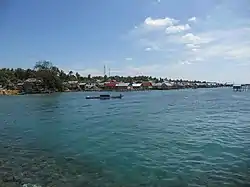 Sea in Tampo Village, Napabalano District, Muna Regency | |
 Coat of arms | |
| Motto(s): Sowite (Muna) (For the sake of my land) | |
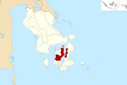 Location within Southeast Sulawesi | |
| Coordinates: 4°50′33″S 122°38′53″E | |
| Country | Indonesia |
| Province | Southeast Sulawesi |
| Capital | Raha |
| Government | |
| • Regent | Laode Muhammad Rusman Emba |
| • Vice Regent | Malik Ditu |
| Area | |
| • Total | 2,057.69 km2 (794.48 sq mi) |
| Population (2018) | |
| • Total | 227,941 |
| • Density | 110/km2 (290/sq mi) |
| Time zone | UTC+8 (ICST) |
| Area code | (+62) 403 |
| Website | munakab |

Administration
The Muna Regency was divided until 2014 into 33 districts (kecamatan), but following the separation of the eleven districts in the west of the island, the remaining twenty-two districts are tabulated below with their areas and their 2010 Census populations[2] and the most recent (2017) estimates.[3]
| Name | Area in km2. | Pop'n Census 2010 | Pop'n Estimate 2017 | No. of Villages | Post Code |
|---|---|---|---|---|---|
| Tongkuno1 | 440.98 | 14,380 | 16,019 | 12 | 93662 |
| Tongkuno Selatan (South Tongkuno) | 57.26 | 5,264 | 5,874 | 6 | 93665 |
| Bone (Bone Tondo) | 130.09 | 5,133 | 5,722 | 5 | 93663 |
| Marobo | 41.37 | 6,116 | 6,765 | 5 | 93666 |
| Parigi | 123.76 | 10,904 | 12,178 | 11 | 93667 |
| Kabawo | 204.94 | 12,172 | 13,498 | 11 | 93661 |
| Kabangka | 97.62 | 9,148 | 10,217 | 9 | 93664 |
| Kowuna Kuntu | 70.56 | 3,736 | 4,142 | 6 | 93660 |
| Central Muna totals | 1,166.58 | 66,853 | 74,415 | 65 | |
| Kontunaga | 50.88 | 7,619 | 8,453 | 7 | 93625 |
| Watopute | 100.12 | 11,684 | 12,981 | 8 | 93624 |
| Katobu | 12.88 | 28,360 | 31,544 | 8 | 93611 -93616 |
| Lohia2 | 49.81 | 13,282 | 14,762 | 9 | 93626 |
| Duruka3 | 11.52 | 11,207 | 12,412 | 7 | 93618 |
| Batalaiworu | 22.71 | 12,640 | 14,063 | 4 | 93614 |
| Napabalano4 | 105.47 | 10,785 | 11,971 | 6 | 93622 |
| Lasalepa | 107.92 | 10,005 | 11,118 | 7 | 93621 |
| Towea5 | 29.02 | 4,722 | 5,246 | 5 | 93623 |
| Northeast Muna totals | 490.33 | 110,304 | 122,550 | 61 | |
| Pasir Putih6 | 89.53 | 4,071 | 4,539 | 6 | 93685 |
| Pasi Kolaga6 | 48.77 | 3,856 | 4,302 | 4 | 93684 |
| Wakorumba Selatan6 (South Wakorumba) | 95.00 | 4,209 | 4,669 | 5 | 93681 |
| Batukara6 | 69.39 | 2,244 | 2,503 | 4 | 93682 |
| Maligano6 | 98.09 | 5,108 | 5,702 | 6 | 93683 |
| West Buton totals6 | 400.78 | 19,488 | 21,715 | 25 |
Notes:
- 1 Tongkuno district includes 43 small islands.
- 2 Lohia district includes 87 small islands.
- 3 Duruka district includes 4 small islands.
- 4 Napabalano district includes 6 small islands.
- 5 Towea is an island off the north coast of Muna.
- 6 the five last-named above lie on the west coast of Buton Island, not on Muna Island. Pasir Putih district includes 3 small islands and Wakorumba Seletan district includes 2 small islands.
References
- Badan Pusat Statistik, Jakarta, 2019.
- Biro Pusat Statistik, Jakarta, 2011.
- Badan Pusat Statistik, Jakarta, 2018.
Regencies and cities of Southeast Sulawesi | ||
|---|---|---|
Capital: Kendari | ||
| Regencies | ||
| Cities | ||