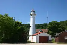
Munising Front Range Light
The Munising Front Range Light and its matching Munising Rear Range Light replaced the ineffective Grand Island East Channel Light in 1905. These two lights combine to guide boats from the open waters of Lake Superior down the East Channel next to Grand Island into the harbor of Munising. The history of these lighthouses is documented by Terry Pepper[2] and is not reproduced here.
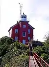
 The light in 2004 from the lake side | |
 | |

| |
| Location | Munising, Michigan |
|---|---|
| Coordinates | 46.41512°N 86.66115°W |
| Year first constructed | 1908 |
| Year first lit | 1908 |
| Construction | Steel |
| Tower shape | Conical |
| Markings / pattern | White |
| Tower height | 58 feet (18 m) |
| Focal height | 79 feet (24 m) |
| Characteristic | F R |
| ARLHS number | USA-948 |
| USCG number | 7-14575[1] |
The Front Range Light is located at the western edge of Munising north of M-28.[3] At this time, the light is managed by the National Park Service, the grounds are open to visitors, but the tower is closed.
According to US Government publication, "The American Practical Navigator", Chapter 5: Range lights are light pairs that indicate a specific line of position when they are in line. The higher rear light is placed behind the front light. When the mariner sees the lights vertically in line, he is on the range line. If the front light appears left of the rear light, the observer is to the right of the range line; if the front appears to the right of the rear, the observer is left of the range line.
References
- Light List, Volume VII, Great Lakes (PDF). Light List. United States Coast Guard. 2011. p. 137.
- Terry Pepper, Seeing the light.
- "The Eastern Lighthouses of Lake Superior", Lighthouses R us
External links
- "Historic Light Station Information and Photography: Michigan". United States Coast Guard Historian's Office. Archived from the original on 2017-05-01.
- Lighthouse Central, Munising Front Range Light, The Ultimate Guide to Upper Michigan Lighthouses by Jerry Roach.. (Publisher: Bugs Publishing LLC - 2007). ISBN 978-0-9747977-2-4.
- Rowlett, Russ. "Lighthouses of the United States: Michigan's Eastern Upper Peninsula". The Lighthouse Directory. University of North Carolina at Chapel Hill.