List of lighthouses in Michigan
This is a list of all lighthouses in the U.S. state of Michigan as identified by the United States Coast Guard. Michigan is home to lights on four of the Great Lakes, Lake St. Clair and connecting waterways.
The first lighthouse in the state, Fort Gratiot Light, was erected in 1825. It is still active.[1] The Michigan.gov website has a Map of Michigan Lighthouses in PDF format.
If not otherwise noted, focal height and coordinates are taken from the United States Coast Guard Light List,[2] while location and dates of activation, automation, and deactivation are taken from the United States Coast Guard Historical information site for lighthouses.[1] (below, 129, Active, Inactive, Moved, Museum; 24, Destroyed)
| Name | Waterway | Location | Coordinates | Image | Focal Height | Built[note 1] | Automated | Deactivated | Status |
|---|---|---|---|---|---|---|---|---|---|
| Alpena Light | Lake Huron | Alpena | 45.06042°N 83.4229°W | 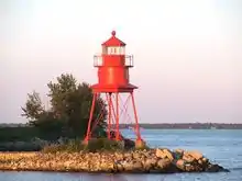 | 44 ft (13 m) | 1877/1914 | 1974 | Active | |
| Au Sable Light | Lake Superior | Burt Township, Alger County | 46.67306°N 86.13933°W | 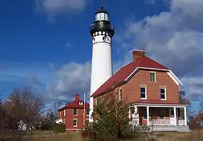 | 100 ft (30 m) | 1874 | 1958 | Active | |
| Au Sable North Pierhead Light | Lake Huron | Au Sable | 44.40662°N 83.3165°W | 25 ft (7.6 m) | Active | ||||
| Beaver Island Harbor Light | Lake Michigan | Beaver Island, northern end | 45.74278°N 85.50861°W |  | 38 ft (12 m) | 1856/1870 | 1927 | Active[note 2] | |
| Beaver Island Head Light | Lake Michigan | Beaver Island, southern tip | 45.57639°N 85.5725°W | 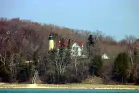 | 103 ft (31 m) | 1851 | 1962 | Inactive[note 3] | |
| Belle Isle Light | Detroit River | Belle Isle | 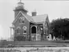 | Destroyed | |||||
| Big Bay Point Light | Lake Superior | Big Bay | 46.84028°N 87.68194°W |  | 89 ft (27 m) | 1896 | 1941 | 1961–1990 | Active[note 4] |
| Big Sable Point Light | Lake Michigan | Ludington | 44.05772°N 86.51444°W | 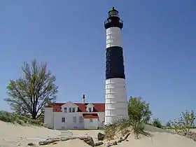 | 106 ft (32 m) | 1867 | Active | ||
| Bois Blanc Light | Lake Huron | Bois Blanc Island | 45.811°N 84.422°W | 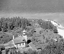 | 32 ft (9.8 m) | 1867 | 1955 | Inactive[note 4] | |
| Caseville Harbor Light | Lake Huron | Caseville | 43.94347°N 83.27278°W | 65 ft (20 m) | Active | ||||
| Cedar River Light | Lake Michigan | Cedar River | 45.40735°N 87.35103°W | 26 ft (7.9 m) | Active | ||||
| Charity Island Light | Lake Huron | Charity Island | 44.03139°N 83.43556°W | 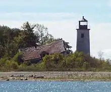 | 45 ft (14 m) | 1857 | 1939 | Inactive[note 4] | |
| Charlevoix South Pier Light Station | Lake Michigan | Charlevoix | 45.32278°N 85.26972°W | 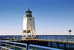 | 41 ft (12 m) | 1914/1948 | Active | ||
| Cheboygan Crib Light | Lake Huron | Cheboygan | 45.6568°N 84.465°W | 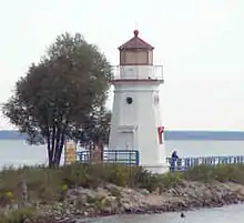 | 35 ft (11 m) | 1857/1901 | 1920 | 1984 | Inactive/Moved[note 5] |
| Cheboygan River Front Range Light | Lake Huron | Cheboygan | 45.64739°N 84.47276°W | 48 ft (15 m) | 1880 | Active | |||
| Clinton River Light | Lake St. Clair | Mount Clemens | 1847 | 1872 | Destroyed[3] | ||||
| Copper Harbor Front Range Light | Lake Superior | Copper Harbor | 47.48111°N 87.86667°W | 28 ft (8.5 m) | 1869 | Active | |||
| Copper Harbor Light | Lake Superior | Copper Harbor | 47.47447°N 87.86025°W | 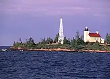 | 90 ft (27 m) | 1849/1933 | 1919 | Active | |
| Crisp Point Light | Lake Superior | McMillan Township, Luce County | 46.75288°N 85.25733°W | 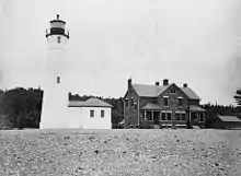 | 62 ft (19 m) | 1904 | 1947 | Inactive/Museum | |
| DeTour Reef Light | Lake Huron | De Tour Village | 45.94892°N 83.90305°W | 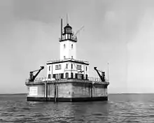 | 74 ft (23 m) | 1847/1931 | 1974 | Active | |
| Detroit River Light | Lake Erie | Rockwood | 42.00075°N 83.14068°W |  | 55 ft (17 m) | 1875/1885 | 1979 | Active | |
| Eagle Harbor Light | Lake Superior | Eagle Harbor | 47.45972°N 88.15917°W | 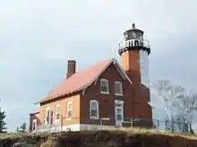 | 60 ft (18 m) | 1851/1871 | 1980 | Active | |
| Eagle Harbor Range Lights | Lake Superior | Eagle Harbor | 47.45562°N 88.15339°W | 1877 | 1911 | Inactive[note 6][4] | |||
| Eagle River Light | Lake Superior | Eagle River | 47.41369°N 88.29828°W |  | 1854/1857 | 1908 | Inactive[note 4] | ||
| Ecorse Light | Detroit River | Ecorse | 32 ft (9.8 m) | 1895 | Destroyed[5] | ||||
| Ecorse Range Rear Light | Detroit River | Ecorse | 45 ft (14 m) | 1894 | Destroyed[6] | ||||
| Fort Gratiot Light | Lake Huron | Port Huron | 43.0063°N 82.42247°W | 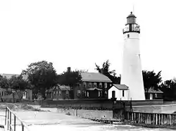 | 82 ft (25 m) | 1825/1829 | 1933 | Active | |
| Forty Mile Point Light | Lake Huron | Rogers Township, Presque Isle County | 45.48667°N 83.91333°W | 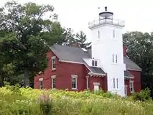 | 66 ft (20 m) | 1897 | 1969 | Active | |
| Fourteen Foot Shoal Light | Lake Huron | Cheboygan County | 45.67981°N 84.435°W | 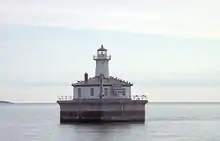 | 51 ft (16 m) | 1930 | Yes | Active | |
| Fourteen Mile Point Light | Lake Superior | Ontonagon | 46.99285°N 89.12573°W | 1894 | 1934 | Inactive[note 4] | |||
| Frankfort Light | Lake Michigan | Frankfort | 44.6306°N 86.2522°W | 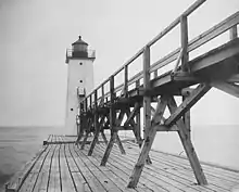 | 72 ft (22 m) | 1873/1932 | Yes | Active | |
| Frankfort South Range Light | Lake Michigan | Frankfort | Destroyed | ||||||
| Frying Pan Island Light | St. Marys River | De Tour Village | 45.98545°N 83.89471°W | 1879/1882 | Active[note 7] | ||||
| Gibraltar Light | Detroit River | Gibraltar | 1838/1873 | 1879 | Destroyed[7] | ||||
| Grand Haven North Pierhead Light | Lake Michigan | Grand Haven | 43.05817°N 86.25589°W | 36 ft (11 m) | Active | ||||
| Grand Haven South Pierhead Entrance Light | Lake Michigan | Grand Haven | 43.05694°N 86.25592°W | 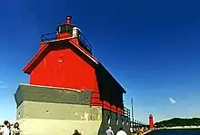 | 42 ft (13 m) | 1839/1905 | 1969 | Active | |
| Grand Haven South Pierhead Inner Light | Lake Michigan | Grand Haven | 43.05725°N 86.25381°W |  | 52 ft (16 m) | 1839/1905 | 1969 | Active | |
| Grand Island East Channel Light | Lake Superior | Munising | 46.45017°N 86.62242°W | 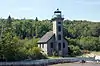 | 1870 | 1913 | Inactive | ||
| Grand Island Harbor Rear Range Light | Lake Superior | Christmas | 46.43667°N 86.69111°W | 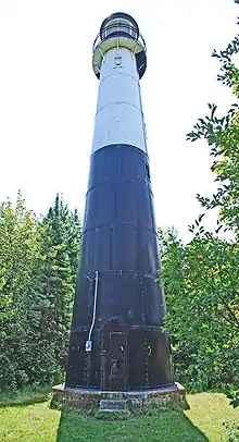 | 70 ft (21 m) | 1868/1914 | 1969 | Inactive | |
| Grand Island North Light | Lake Superior | Grand Island | 46.55889°N 86.69111°W |  | 1854/1867 | 1927 | 1961 | Inactive[note 4] | |
| Grand Marais Range Lights | Lake Superior | Grand Marais | 46.68389°N 85.97222°W |  | 54 ft (16 m) (inner) 40 ft (12 m) (outer) | 1895 | Active | ||
| Grand Traverse Light | Lake Michigan | Leelanau Peninsula | 45.21°N 85.55°W |  | 47 ft (14 m) | 1852/1858 | 1972 | 1972 | Inactive/Museum |
| Granite Island Light | Lake Superior | Granite Island | 46.72083°N 87.41194°W |  | 96 ft (29 m) | 1868 | 1939 | Active[note 8] | |
| Grassy Island North Channel Range Lights | Detroit River | Grassy Island | 1897 | Destroyed | |||||
| Grassy Island South Channel Range Lights (formerly Grassy Island Light) | Detroit River | Grassy Island | 1849/1896 | Destroyed | |||||
| Gravelly Shoal Light | Lake Huron | Saginaw Bay | 44.01833°N 83.53722°W | 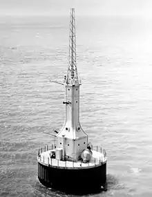 | 75 ft (23 m) | 1939 | Active | ||
| Grays Reef Light | Lake Michigan | Bliss Township, Emmet County | 45.76667°N 85.15333°W |  | 82 ft (25 m) | 1891/1936 | 1976 | Active | |
| Grosse Ile North Channel Range Lights | Detroit River | Grosse Ile | 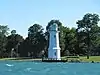 | 1894/1906 | 1963 | Destroyed (rear) Inactive (front)[note 4] | |||
| Grosse Ile South Channel Range Lights | Detroit River | Grosse Ile | Active[note 9] | ||||||
| Gull Rock Light | Lake Superior | Manitou Island, offshore west | 47.41722°N 87.66361°W | 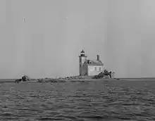 | 50 ft (15 m) | 1867 | 1913 | Active | |
| Harbor Beach Light | Lake Huron | Harbor Beach, Michigan | 43.845°N 82.63167°W |  | 54 ft (16 m) | 1858/1885 | 1968 | Active[note 10] | |
| Harwood Point East Range Front Light | St. Marys River | Sugar Island | Destroyed | ||||||
| Holland Harbor Light | Lake Michigan | Holland | 42.77269°N 86.21242°W | 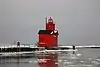 | 52 ft (16 m) | 1872/1936 | 1932 | Active | |
| Huron Island Light | Lake Superior | Powell Township, Marquette County | 46.96333°N 87.99833°W | .jpg.webp) | 197 ft (60 m) | 1868/1877 | 1972 | Active | |
| Ile Aux Galets Light | Lake Michigan | Emmet County | 45.67639°N 85.17306°W | 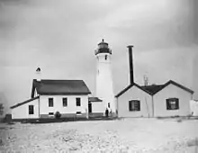 | 58 ft (18 m) | 1850/1888 | 1969 | Active | |
| Isle Royale Light | Lake Superior | Isle Royale | 47.9479°N 88.7612°W | 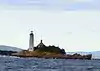 | 72 ft (22 m) | 1875 | 1913 | Active | |
| Kalamazoo River Light (Saugatuck Light) | Lake Michigan | Saugatuck | 1858 | 1914 | Destroyed | ||||
| Keweenaw Waterway Lower Entrance Light | Lake Superior | Jacobsville | 46.96879°N 88.4311°W | 68 ft (21 m) | 1868/1920 | 1973 | Active | ||
| Keweenaw Waterway Upper Entrance Light | Lake Superior | Stanton Township, Houghton County | 47.23454°N 88.63029°W | 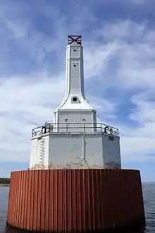 | 82 ft (25 m) | 1874/1950 | 1973 | Active | |
| Lake St. Clair Light | Lake St. Clair | Harsens Island | 42.50854°N 82.69846°W | 43 ft (13 m) | 1941 | Yes | Active | ||
| Lansing Shoals Light | Lake Michigan | Newton Township, Mackinac County | 45.90333°N 85.56167°W | 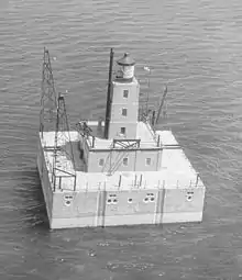 | 69 ft (21 m) | 1900/1928 | 1976 | Active | |
| Little Sable Point Light | Lake Michigan | Golden Township, Oceana County | 43.65167°N 86.53889°W | 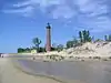 | 108 ft (33 m) | 1874 | 1955 | Active | |
| Little Traverse Light | Lake Michigan | Harbor Springs | 45.41919°N 84.97741°W |  | 72 ft (22 m) | 1884/1963 | Active[note 11] | ||
| Ludington Light | Lake Michigan | Ludington | 43.95361°N 86.46937°W |  | 55 ft (17 m) | 1871/1924 | 1972 | Active | |
| Mama Juda Light | Detroit River | Mamajuda Island | 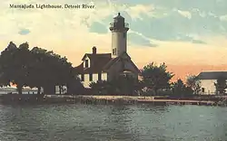 | Destroyed | |||||
| Mama Juda Range Front Light | Detroit River | Mamajuda Island | Destroyed | ||||||
| Manistee Main Light | Lake Michigan | Manistee | Destroyed | ||||||
| Manistee Pierhead lights | Lake Michigan | Manistee | 44.2517°N 86.3464°W |  | 55 ft (17 m) (north) 29 ft (8.8 m) (south) | 1875/1927 | 1927 | Active | |
| Manistique East Breakwater Light | Lake Michigan | Manistique | 45.94478°N 86.24765°W | 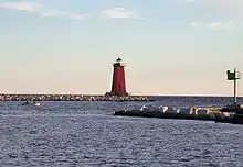 | 50 ft (15 m) | 1915/1917 | 1969 | Active | |
| Manitou Island Light | Lake Superior | Manitou Island | 47.41972°N 87.58722°W | 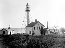 | 81 ft (25 m) | 1850/1861 | 1978 | Active | |
| Manning Memorial Light | Lake Michigan | Empire | 44.80793°N 86.25521°W |  | 38 ft (12 m) | 1990 | Yes | Active | |
| Mariners Memorial (River Rouge) Light | Detroit River | River Rouge | 42.27101°N 83.11128°W | .jpg.webp) | 2003[8] | Active[note 12] | |||
| Marquette Breakwater Outer Light | Lake Superior | Marquette | 46.5338°N 87.37473°W | 36 ft (11 m) | 1875/1908 | Active | |||
| Marquette Harbor Light | Lake Superior | Marquette | 46.54669°N 87.37604°W | 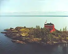 | 77 ft (23 m) | 1853/1866 | Active | ||
| Martin Reef Light | Lake Huron | Clark Township, Mackinac County | 45.91333°N 84.14833°W | .jpg.webp) | 65 ft (20 m) | 1927 | Yes | Active | |
| McGulpin Point Light | Straits of Mackinac | Wawatam Township, Emmet County | 45.7869°N 84.7722°W | 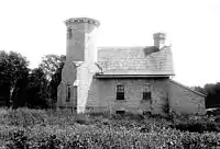 | 102 ft (31 m) | 1869 | Active | ||
| Mendota (Bete Grise) Light | Lake Superior | Delaware | 47.37417°N 87.96667°W | 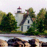 | 44 ft (13 m) | 1870/1895 | 1933 | 1960–1998 | Active[note 4] |
| Menominee Pier Light | Lake Michigan | Menominee | 45.11392°N 87.58603°W | 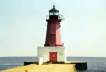 | 46 ft (14 m) | 1887/1927 | 1972 | Active | |
| Middle Island Light | Lake Huron | Alpena Township, Alpena County | 45.19306°N 83.32111°W |  | 78 ft (24 m) | 1905 | Yes | Active | |
| Middle Lake George Light | St. Marys River | Sugar Island | Destroyed | ||||||
| Miller Memorial Light | Lake St. Clair | St. Clair Shores | 42.46375°N 82.87917°W | 270 ft (82 m) | Active | ||||
| Minneapolis Shoal Light | Lake Huron | Big Bay de Noc | 45.53611°N 86.99833°W |  | 82 ft (25 m) | 1935 | 1979 | Active | |
| Mission Point Light | Lake Michigan | Old Mission Point | 44.99131°N 85.47947°W | 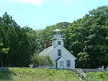 | 47 ft (14 m) | 1870 | 1933 | Inactive | |
| Mission Point Light (1933) | Lake Michigan | Old Mission Point | 45.01823°N 85.50603°W | 41 ft (12 m) | 1933 | Active | |||
| Monroe Pier Light | Lake Erie | Monroe | 1849/1884 | 1916 | Destroyed | ||||
| Munising Front Range Light | Lake Superior | Munising | 46.41512°N 86.66115°W | 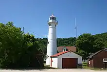 | 79 ft (24 m) | 1908 | Yes | Active | |
| Munising Rear Range Light | Lake Superior | Munising | 46.41254°N 86.66396°W |  | 107 ft (33 m) | 1908 | Yes | Active | |
| Muskegon Breakwater Light | Lake Michigan | Muskegon | 45.19075°N 83.34689°W |  | 70 ft (21 m) | 1851/1871 | Active | ||
| Muskegon Pier Light | Lake Michigan | Muskegon | 43.22665°N 86.34126°W |  | 50 ft (15 m) | 1903 | Active | ||
| Naubinway Island Light | Lake Michigan | Naubinway | 46.0756°N 85.44497°W | 32 ft (9.8 m) | Active | ||||
| New Buffalo Light | Lake Michigan | New Buffalo | Destroyed | ||||||
| North Manitou Island Light | Lake Michigan | North Manitou Island | 45.063°N 85.964°W | 1899 | 1935 | Destroyed | |||
| North Manitou Shoal Light | Lake Michigan | North Manitou Island | 45.021°N 85.95713°W | 79 ft (24 m) | 1935 | 1980 | Active | ||
| Old Mackinac Point Light | Straits of Mackinac | Mackinaw City | 45.7875°N 84.72944°W | 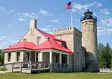 | 62 ft (19 m) | 1889/1892 | 1957 | Inactive | |
| Ontonagon Harbor West Breakwater Light | Lake Superior | Ontonagon | 46.87947°N 89.33084°W | 31 ft (9.4 m) | Active | ||||
| Ontonagon Light | Lake Superior | Ontonagon | 46.87361°N 89.31861°W | 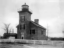 | 1852/1866 | 1964 | Inactive | ||
| Passage Island Light | Lake Superior | Isle Royale | 48.2237°N 88.36558°W |  | 78 ft (24 m) | 1882 | 1978 | Active | |
| Peche Island Rear Range Light | Lake St. Clair | Peche Island, offshore west | 42.3536°N 82.9172°W | 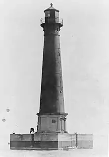 | 114 ft (35 m) | 1908/1983 | Active[note 13] | ||
| Peninsula Point Light | Lake Michigan | Bay de Noc Township, Delta County | 45.6682°N 86.9666°W | 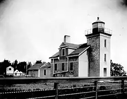 | 40 ft (12 m) | 1856/1866 | 1922 | 1936 | Inactive |
| Pentwater North Pierhead Light | Lake Michigan | Pentwater | 43.78083°N 86.44028°W | 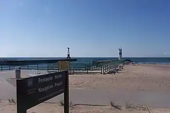 | 43 ft (13 m) | Active | |||
| Pipe Island Light | St. Marys River | Drummond Township, Chippewa County | 46.01633°N 83.8993°W | 52 ft (16 m) | 1888 | 1937 | Active | ||
| Poe Reef Light | Lake Huron | Bois Blanc Island, offshore | 45.695°N 84.36167°W | 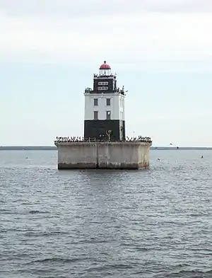 | 71 ft (22 m) | 1893/1929 | 1974 | Active | |
| Point Betsie Light | Lake Michigan | Lake Township, Benzie County | 44.6913°N 86.2552°W | 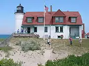 | 52 ft (16 m) | 1854 | 1984 | Active | |
| Point Iroquois Light | Lake Superior | Bay Mills Township, Chippewa County | 46.48368°N 84.62568°W |  | 72 ft (22 m) | 1855/1871 | 1962 | 1971 | Inactive |
| Pointe aux Barques Light | Lake Huron | Port Hope | 44.02333°N 82.79333°W | 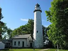 | 93 ft (28 m) | 1848/1857 | 1958 | Active | |
| Port Austin Light | Lake Huron | Port Austin, offshore | 44.08333°N 82.98333°W |  | 76 ft (23 m) | 1878/1899 | Yes | Active | |
| Port Sanilac Light | Lake Huron | Port Sanilac | 43.42901°N 82.5402°W | 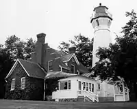 | 69 ft (21 m) | 1886 | 1925 | Active | |
| Portage Lake Light | Lake Michigan | Portage Lake | 1891 | Destroyed | |||||
| Portage River (Jacobsville) Light | Lake Superior | Torch Lake Township, Houghton County | 46.97803°N 88.41399°W | 1856/1870 | 1920 | Inactive[note 4] | |||
| Poverty Island Light | Lake Michigan | Poverty Island | 45.52722°N 86.66361°W | 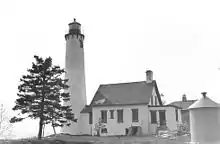 | 78 ft (24 m) | 1874 | 1957 | 1976 | Inactive |
| Presque Isle Harbor Breakwater Light | Lake Superior | Marquette | 46.574144°N 87.374577°W | ||||||
| Presque Isle Light (new) | Lake Huron | Presque Isle Township, Presque Isle County | 45.28722°N 83.47389°W | 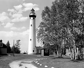 | 123 ft (37 m) | 1871 | 1970 | Active | |
| Presque Isle Light (old) | Lake Huron | Presque Isle Township, Presque Isle County | 45.34203°N 83.47828°W | 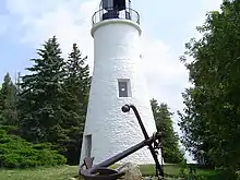 | 36 ft (11 m) | 1840 | 1871 | Inactive/Museum | |
| Rock Harbor Light | Lake Superior | Rock Harbor | 48.08917°N 88.57917°W | 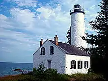 | 1855 | 1879 | Inactive | ||
| Rock of Ages Light | Lake Superior | Washington Island, offshore | 47.86667°N 89.31333°W |  | 130 ft (40 m) | 1908 | 1978 | Active | |
| Rouleau Point Range Front and Rear Lights | Keweenaw Waterway | Washington Island, offshore | 47.19549°N 88.61601°W (rear) 47.19256°N 88.61885°W (front) | 55 ft (17 m) (rear) 26 ft (7.9 m) (front) | 1897/1937 | Yes | Active | ||
| Round Island Light | Straits of Mackinac | Round Island | 45.83717°N 84.61658°W | 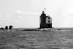 | 53 ft (16 m) | 1895 | 1924 | 1947–1996 | Active |
| Round Island Light (St. Mary's River) | St. Marys River | Round Island | 46.10897°N 84.01993°W | 1892 | Inactive[note 4] | ||||
| Round Island Passage Light | Straits of Mackinac | Round Island Channel | 45.84333°N 84.615°W | 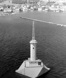 | 71 ft (22 m) | 1947 | 1973 | Active | |
| Saginaw Bay Light | Lake Huron | Bay City | 1831 | 1876 | Destroyed | ||||
| Saginaw River Rear Range Light | Lake Huron | Bay City | 43.6355°N 83.85056°W | 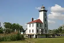 | 77 ft (23 m) | 1876 | 1954 | 1962 | Inactive[note 4] |
| Sand Beach North Entrance East Light | Lake Huron | Destroyed | |||||||
| Sand Hills Light | Lake Superior | Ahmeek | 47.39194°N 88.37042°W | 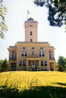 | 93 ft (28 m) | 1919 | 1939 | 1954 | Inactive[note 4] |
| Sand Point Light | Lake Michigan | Escanaba | 45.74444°N 87.04444°W | 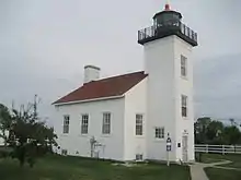 | 44 ft (13 m) | 1867 | 1934 | Inactive/Museum | |
| Sand Point Light (Baraga) | Lake Superior | Baraga | 46.78337°N 88.46685°W | 1878 | 1922 | Inactive | |||
| Seul Choix Light | Lake Michigan | Mueller Township, Schoolcraft County | 45.92139°N 85.91194°W | 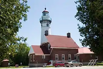 | 80 ft (24 m) | 1892 | 1972 | Active | |
| Six Mile Point Range Rear Light | St. Marys River | Inactive/Moved[note 14] | |||||||
| South Fox Island Light | Lake Michigan | South Fox Island | 45.3785°N 85.8371°W | 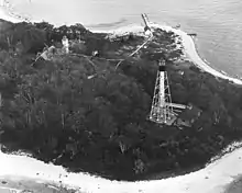 | 39 ft (12 m) | 1867/1934 | 1969 | Inactive | |
| South Haven Light | Lake Michigan | South Haven | 42.40222°N 86.28444°W | 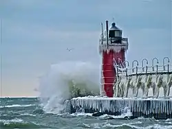 | 37 ft (11 m) | 1872/1903 | Yes | Active | |
| South Manitou Island Light | Lake Michigan | South Manitou Island | 45.00768°N 86.09378°W | 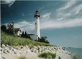 | 54 ft (16 m) | 1839/1872 | 1935 | 1967–2009 | Active |
| Spectacle Reef Light | Lake Huron | Cheboygan County | 45.77333°N 84.13667°W | 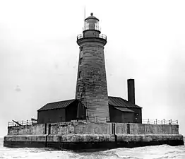 | 86 ft (26 m) | 1874 | 1972 | Active | |
| Squaw Point Light | Lake Michigan | Destroyed | |||||||
| Squaw Island Light | Lake Michigan | Squaw Island | 45.8399°N 85.58713°W | 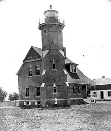 | 1892 | Inactive[note 4] | |||
| St. Clair Flats Front and Rear Range Light | Lake St. Clair | Harsens Island, offshore | 42.5375°N 82.69472°W | 1859 | Active[note 15] | ||||
| St. Helena Island Light | Straits of Mackinac | St. Helena Island | 45.855°N 84.86333°W |  | 71 ft (22 m) | 1873 | 1922 | Active | |
| St. Joseph North Pier Inner Light | Lake Michigan | St. Joseph | 42.1161°N 86.49348°W | 53 ft (16 m) | 1832/1906 | Active | |||
| St. Joseph North Pier Outer Light | Lake Michigan | St. Joseph | 42.11633°N 86.49456°W | 31 ft (9.4 m) | 1832/1906 | Active | |||
| St. Martin Island Light | Lake Michigan | St. Martin Island | 45.50278°N 86.7575°W | 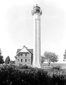 | 81 ft (25 m) | 1905 | Inactive | ||
| St. Mary's River Lower Range Front Light | St. Marys River | Destroyed | |||||||
| Stannard Rock Light | Lake Superior | Keweenaw Peninsula, offshore | 47.18351°N 87.22512°W |  | 102 ft (31 m) | 1882 | 1962 | Active | |
| Sturgeon Point Light | Lake Huron | Haynes Township, Michigan, Alcona County | 44.71269°N 83.27272°W |  | 69 ft (21 m) | 1869 | 1939 | Active | |
| Tawas Point Light | Lake Huron | Baldwin Township, Iosco County | 44.254°N 83.449°W | 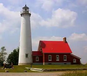 | 70 ft (21 m) | 1853/1876 | 2016 | Inactive/Museum | |
| Thunder Bay Island Light | Lake Huron | Alpena County | 45.04167°N 83.2°W |  | 63 ft (19 m) | 1832 | 1983 | Active | |
| Tri-Centennial Light of Detroit | Detroit River | Detroit | 42.33229°N 83.02509°W | Active | |||||
| Vidal Shoals Channel Range Front and Rear Lights | St. Marys River | Sault Ste. Marie | 46.5045°N 84.36374°W (rear) 46.50392°N 84.36715°W (front) | 66 ft (20 m) (rear) 32 ft (9.8 m) (front) | Active | ||||
| Waugoshance Light | Lake Michigan | Emmet County | 45.78611°N 85.09111°W | 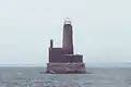 | 74 ft (23 m) | 1851 | 1912 | Inactive | |
| White River Light | Lake Michigan | Whitehall | 43.37473°N 86.42433°W | 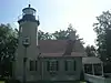 | 1875 | 1945 | 1960 | Inactive/Museum | |
| White Shoal Light | Lake Michigan | Emmet County | 45.84222°N 85.13528°W | 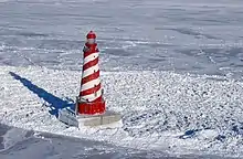 | 125 ft (38 m) | 1891/1910 | 1976 | Active | |
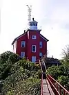
| Whitefish Point Light | Lake Superior | Whitefish Township, Chippewa County | 46.77056°N 84.95667°W | 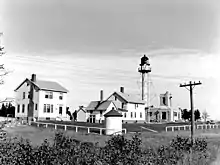 | 80 ft (24 m) | 1848/1861 | 1970 | Active | |
| William Livingstone Memorial Light | Detroit River | Belle Isle | 42.34702°N 82.95431°W | 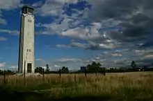 | 58 ft (18 m) | 1930[9] | Active | ||
| Windmill Point Light | Detroit River | Detroit | 42.35756°N 82.92996°W | 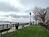 | 42 ft (13 m) | 1933[10] | Active | ||
| Windmill Point Range Front and Rear Lights | Detroit River | Detroit | Destroyed | ||||||
| Winter Point Range Front Light | St. Marys River | 46.22608°N 84.14409°W | 46 ft (14 m) | Active |
See also
Notes
- If there is a second date, it represents the date the most recent tower was lit.
- Also known as St. James Light.
- Owned by Charlevoix Public School System.
- Private owner.
- Moved to Gordon Turner Park
- Private owner. Moved across the street.
- Replaced with pole light. Tower moved to Sault Ste. Marie Coast Guard station.
- Replaced with light on metal tower. Lighthouse is privately owned.
- Replaced with skeleton towers.
- Owned by the City of Harbor Beach
- Replaced with skeleton tower.
- Owned by the City of River Rouge. Located in Belanger Park.
- Replaced with skeleton tower. Original tower moved to Marine City Waterfront Park.
- Moved to Les Cheneaux Maritime Museum.
- Only front light active.
References
- "Historic Light Station Information and Photography: Michigan". United States Coast Guard Historian's Office. Archived from the original on 2017-05-01.
- Light List, Volume VII, Great Lakes (PDF). Light List. United States Coast Guard. 2015.
- "Clinton River Light". Lighthouse Digest Magazine.
- "Eagle Harbor Range Lights". Seeing The Light.
- "Ecorse Light". Lighthouse Digest Magazine.
- "Ecorse Rear Range Light". Lighthouse Digest Magazine.
- "Gibraltar Light (MI)". Lighthouse Digest Magazine.
- "Belanger Park". City of River Rouge.
- "William Livingstone Memorial, MI". lighthousefriends.com.
- "Windmill Point, MI". lighthousefriends.com.
External links
General
This article is issued from Wikipedia. The text is licensed under Creative Commons - Attribution - Sharealike. Additional terms may apply for the media files.