Munya, Nigeria
Munya is a Local Government Area in Niger State, Nigeria. Its headquarters are in the town of Sarkin Pawa in the north of the area near Kaduna State at10°01′00″N 7°06′00″E.
Munya | |
|---|---|
LGA | |
 Munya Location in Nigeria | |
| Coordinates: 9°47′N 7°02′E | |
| Country | |
| State | Niger State |
| Government | |
| • Local Government Chairman and the Head of the Local Government Council | Abdullahi Moh’d Ricco |
| Area | |
| • Total | 2,176 km2 (840 sq mi) |
| Population (2006 census) | |
| • Total | 103,651 |
| Time zone | UTC+1 (WAT) |
| 3-digit postal code prefix | 921 |
| ISO 3166 code | NG.NI.MU |
It has an area of 2,176 km2 and a population of 103,651 at the 2006 census.
The postal code of the area is 921.[1]
It is located in the eastern region of the state. Its main inhabitants are the Gwari people with farming as their main occupation.
Guni
Munya is made up of eight political wards with Guni ward as the largest and strongest of all. Guni as its popularly called, is the back bone of the whole state at large with most of the missionary schools in the state capital were relocated from Guni. in the local government level, Guni is the town with the most elite people to include the Magaji's family which over the years have contributed to the development and creation of the local government and partly the state at large.
References
- "Post Offices- with map of LGA". NIPOST. Archived from the original on 2009-10-07. Retrieved 2009-10-20.
State capital: Minna | ||
| Local Government Areas | 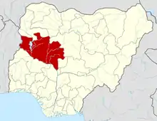 | |
