Musheirifa
Al-Musheirifa (Arabic: المشيرفة, Hebrew: מושיריפה or מושיירפה) is an Arab village in Israel's Haifa District. The village is located in the Wadi Ara area of the northern Triangle, 4 kilometres (2.5 mi) northeast of Umm al-Fahm. Since 1996, it has been under the jurisdiction of the Ma'ale Iron local council. In mid-2016 Musheirifa's population was 3472,[1] all of whom are Muslim. The village is divided into four neighborhoods: Ighbarieh, El-Manshya, Jabbarin, and the Old Village.[3] The inhabitants are largely members of the Ighbarieh clan, which inhabits the upper parts of the village, and the Jabbarin clan, which inhabit the lower parts. Bayada was a neighborhood of the village in the past but split from it and became a new village. The village has poor infrastructure and, like many other villages in the Wadi Ara region, lacks many social institutions and recreational areas.[4]
Musheirifa
| |
|---|---|
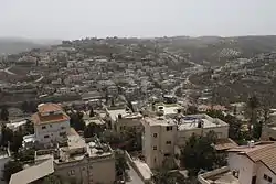 Musheirifa in 2015 | |
 Musheirifa  Musheirifa | |
| Coordinates: 32°33′0″N 35°9′0″E | |
| Grid position | 164/217 PAL |
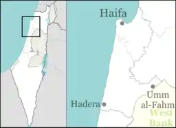
| Country | |
| District | |
| Council | Ma'ale Iron |
| Population (mid-2016[1]) | |
| • Total | 3,472 |
| Name meaning | "The High Places"[2] |
History
Ottoman and British Mandate periods
According to local tradition, Musheirifa was established in 1880 by people from nearby Umm al-Fahm.[5] In the Palestine Exploration Fund's 1882 Survey of Western Palestine, Musheirifa was described as a "very small hamlet on high ground, with a well to the south".[6]
In the 1922 census conducted by the British Mandate authorities, the population of the village was 203, all of whom were Muslim,[7] increasing in the 1931 census to 233, still all Muslim, living in 45 houses.[8]
In the 1945 statistics, Musheirifa's population was counted (together with other villages) under Umm al-Fahm.[9][10][11][12]
1948 war
During the 1948 Arab-Israeli War the village and the surrounding area came under Iraqi control.[13] On 15 April 1948, Jewish forces raided the village and did not capture it.[14] In March 1949 Jordanian forces replaced the Iraqi forces in Wadi Ara.[13] On 3 April 1949 Israel and Jordan signed an armistice agreement in which Israel would receive the Wadi Ara area.[15]
State of Israel
Musheirifa is one of the villages of Wadi Ara that lacked municipal status after the establishment of Israel.[16] It was under the administration of mukhtars (village headmen) who were appointed by the Interior Ministry[17] until 1992, when the Interior Ministry established the Nahal Iron regional council. The locals objected to the administrative arrangement, and sought independent municipal status for each village. To allay local concerns, the Interior Ministry established an investigative committee to examine other options, and in 1996, decided to split the regional council into two local councils: Ma'ale Iron, which includes Musheirifa, and Basma.[18]
| Year | 1922 | 1931 | 1961 | 1972 | 1983 | 1995 | 2008 | 2016 |
|---|---|---|---|---|---|---|---|---|
| Population | 203 | 233 | 578 | 982 | 1,523 | 2,049 | N/A* | 3,472 |
*In the 2008 census Musheirifa's population was counted with Bayada and together their population was 3,100.[3]
Geography
The village is located on a group of hills overlooking the Jezreel Valley, which gives it its name "The High Places".[2][4] The Ba'ana river flows through the village.[20] In the middle of the village there is a spring which used to provide water to the residents until it dried in recent years. There is another spring some 3 kilometres (1.9 mi) from the village called "eayan alhajar" (Arabic: عين الحجر), or "Stone Spring". It was used for irrigation and as a recreational site for the residents. Today the spring still flows but the amount of water decreased. Around the spring there are mint plants.[4]
See also
References
- "معطيات واحصائيات" [Data and Statistics]. Ma'ale Iron Local Council.
- Palmer, 1881; El Mesheirfeh, "the high places" p. 151
- "מפקד אוכלוסין 2008 – מעלה עירון – איזור סטטיסטי 3" [2008 Census – Ma'ale Iron – Statistical area 3] (PDF) (in Hebrew). Israeli Central Bureau of Statistics. Retrieved 30 April 2016.
- "MOSHIRFA VILLAGE". Umm El Fahem Archive. Retrieved 24 April 2016.
- "מושיריפה" [Musheirifa] (in Hebrew). Mapa. Retrieved 29 April 2016.
- Conder and Kitchener, 1882, SWP II, p. 45
- Barron, 1923, Table IX, Sub-district of Jenin, p. 30
- Mills, 1932, p. 69
- Government of Palestine, Department of Statistics, 1945, p. 17
- Government of Palestine, Department of Statistics. Village Statistics, April, 1945. Quoted in Hadawi, 1970, p. 55
- Government of Palestine, Department of Statistics. Village Statistics, April, 1945. Quoted in Hadawi, 1970, p. 100
- Government of Palestine, Department of Statistics. Village Statistics, April, 1945. Quoted in Hadawi, 1970, p. 150
- The Politics of Partition; King Abdullah, The Zionists, and Palestine 1921–1951 Avi Shlaim Oxford University Press Revised Edition 2004 ISBN 0-19-829459-X pp. 299, 312
- "נתוני קרב: מושיירפה" [Battle details: Musheirifa] (in Hebrew). Independence War sites. Retrieved 24 April 2016.
- "Israel-Jordan Armistice Agreement". Ministry of Foreign Affairs. Retrieved 20 April 2016.
- Peretz, Issac (16 May 1986). "הודעה בדבר בצגת רשימות הבוחרים לכנסת לשנת פנקס החוברים ה'תשמ"ו/ה'תשמ"ז – 1986–1987" [Announcement about presentation of the lists of electors for the Knesset for Electoral Register year 5746-7 (1986–7)]. Ministry of Interior (Israel). Maariv. Retrieved 10 April 2016.
- "מעלה עירון [Ma'ale Iron]" (in Hebrew). Iron Construction Committee. Archived from the original on 4 March 2016. Retrieved 13 May 2016.
- "لمحة عامة" [Overview]. Ma'ale Iron Regional Council (in Hebrew).
- 1995 Census - List of communities, geographical characters and population 1948, 1961, 1972, 1983, 1995 Archived 2012-04-13 at the Wayback Machine, Israel Central Bureau of Statistics. Retrieved 25 May 2016
- "סיום השיקום של קו מעלה עירון – מים צלולים בנחל בענא" [Completion of the restoration of Ma'ale Iron line – fresh water in Ba'ana river] (in Hebrew). Ministry of Environmental Protection (Israel). Retrieved 24 April 2016.
Bibliography
- Barron, J.B., ed. (1923). Palestine: Report and General Abstracts of the Census of 1922. Government of Palestine.
- Conder, C.R.; Kitchener, H.H. (1882). The Survey of Western Palestine: Memoirs of the Topography, Orography, Hydrography, and Archaeology. 2. London: Committee of the Palestine Exploration Fund.
- Government of Palestine, Department of Statistics (1945). Village Statistics, April, 1945.
- Hadawi, S. (1970). Village Statistics of 1945: A Classification of Land and Area ownership in Palestine. Palestine Liberation Organization Research Centre.
- Mills, E., ed. (1932). Census of Palestine 1931. Population of Villages, Towns and Administrative Areas. Jerusalem: Government of Palestine.
- Palmer, E.H. (1881). The Survey of Western Palestine: Arabic and English Name Lists Collected During the Survey by Lieutenants Conder and Kitchener, R. E. Transliterated and Explained by E.H. Palmer. Committee of the Palestine Exploration Fund.
External links
- Welcome To Musheirifa
- Survey of Western Palestine, Map 8: IAA, Wikimedia commons
