NUTS statistical regions of Greece
The NUTS codes of Greece are part of the Nomenclature of Territorial Units for Statistics, an official nomenclature of the European Commission used by Eurostat for statistical purposes.
Changes
In 2011, the NUTS1 code of Greece was changed from GR to EL. GR1 was changed to EL5, GR2 to EL6, GR3 to EL3 and GR4 to EL4.[1] The change became official per European Commission regulation No. 31/2011. With regard to the transmission of data to Eurostat, the new codes entered into force by 1 January 2012.[2]
Following the Kallikrates territorial reform, the NUTS regions of Greece were redefined. With the region of Epirus being reclassified as part of Voreia Ellada (Northern Greece, former EL1), and the region of Thessaly in exchange going to Kentriki Ellada (Central Greece, former EL2), new NUTS1 codes have been assigned to both regions. Apart from that, a number of third-level divisions have been changed. The changes became official in December 2013 by European Commission regulation No. 1319/2013. With regard to the transmission of data to Eurostat, the new codes entered into force by 1 January 2015.[3]
NUTS levels
The three NUTS levels are as follows:
| Level | Subdivisions | # |
|---|---|---|
| NUTS 1 | Groups of development regions | 4 |
| NUTS 2 | Regions (Perifereies) | 13 |
| NUTS 3 | Regional units or combinations thereof, sometimes equivalent to former Prefectures (Nomoi) |
52 |
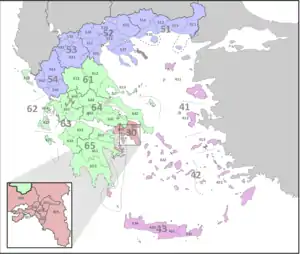
NUTS codes
Per 1 January 2015, the NUTS codes for Greece are as follows:
Local administrative units
Below the NUTS levels, the two LAU (Local Administrative Units) levels are:
| Level | Subdivisions | # |
|---|---|---|
| LAU 1 | Municipalities (Dimoi) | 1035 |
| LAU 2 | Municipal units, municipal communities, local units | 6130 |
References
- Eurostat. "History of NUTS". Retrieved 25 April 2016.
- European Commission (18 January 2011). "Commission Regulation (EU) No. 31/2011 of 17 January 2011". Official Journal of the European Union. Retrieved 9 March 2015.
- European Commission (18 December 2013). "Commission Regulation (EU) No. 1319/2013 of 9 December 2013". Official Journal of the European Union. Retrieved 9 March 2015.
External links
- Hierarchical list of the Nomenclature of territorial units for statistics – NUTS and the Statistical regions of Europe
- Overview map of EU Countries – NUTS level 1
- Correspondence between the NUTS levels and the national administrative units
- List of current NUTS codes
- Departments of Greece, Statoids.com