National Register of Historic Places listings in Calvert County, Maryland
This is a list of the National Register of Historic Places listings in Calvert County, Maryland.
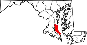
Location of Calvert County in Maryland
This is intended to be a complete list of the properties and districts on the National Register of Historic Places in Calvert County, Maryland, United States. Latitude and longitude coordinates are provided for many National Register properties and districts; these locations may be seen together in a map.[1]
There are 20 properties and districts listed on the National Register in the county, including 2 National Historic Landmarks.
| Allegany - Anne Arundel - Baltimore (city) - Baltimore County - Calvert - Caroline - Carroll - Cecil - Charles - Dorchester - Frederick - Garrett - Harford - Howard - Kent - Montgomery - Prince George's - Queen Anne's - Somerset - St. Mary's - Talbot - Washington - Wicomico - Worcester |
- This National Park Service list is complete through NPS recent listings posted January 29, 2021.[2]
Current listings
| [3] | Name on the Register[4] | Image | Date listed[5] | Location | City or town | Description |
|---|---|---|---|---|---|---|
| 1 | All Saints' Church | 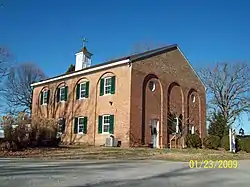 All Saints' Church |
March 14, 1973 (#73000908) |
100 Lower Marlboro Road, near the intersection of Southern Maryland Boulevard and Solomons Island Road 38°39′42″N 76°36′26″W |
Sunderland | |
| 2 | Cedar Hill | 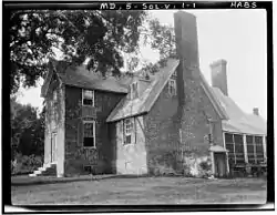 Cedar Hill |
May 22, 1973 (#73000905) |
2 miles west of Barstow on Buena Vista Rd. 38°31′57″N 76°37′58″W |
Barstow | |
| 3 | Chesapeake Beach Railway Station | 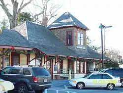 Chesapeake Beach Railway Station |
September 11, 1980 (#80001798) |
8005 Bayside Rd. 38°41′24″N 76°32′03″W |
Chesapeake Beach | |
| 4 | Christ Church | 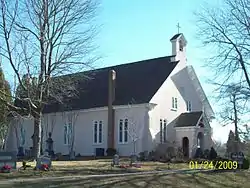 Christ Church |
November 12, 1975 (#75000871) |
Southwest of Port Republic on Broome Island Rd. 38°29′38″N 76°32′12″W |
Port Republic | |
| 5 | Cornehill | October 31, 1972 (#72000572) |
Emmanuel Church Rd. 38°35′20″N 76°33′19″W |
Parran | ||
| 6 | Cove Point Lighthouse |  Cove Point Lighthouse |
April 11, 1973 (#73000907) |
3500 Lighthouse Boulevard, off Maryland Route 497 38°23′10″N 76°22′55″W |
Lusby | |
| 7 | Drum Point Lighthouse | 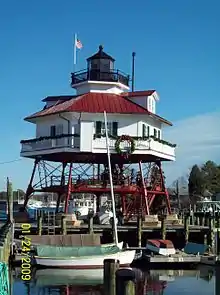 Drum Point Lighthouse |
April 11, 1973 (#73000910) |
West shore of Back Creek, Calvert Marine Museum 38°19′52″N 76°27′49″W |
Solomons Island | |
| 8 | Grahame House |  Grahame House |
April 26, 1972 (#72000571) |
Northeast of Maryland Routes 262 and 523 38°39′25″N 76°40′42″W |
Lower Marlboro | |
| 9 | La Veille | September 20, 1973 (#73000909) |
West of Mutual on Ben La Veille Rd. off Maryland Route 264 38°28′33″N 76°35′25″W |
Mutual | ||
| 10 | Linden | 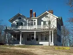 Linden |
March 24, 2000 (#00000285) |
70 Church St. 38°32′24″N 76°35′16″W |
Prince Frederick | |
| 11 | J. C. Lore Oyster House | 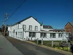 J. C. Lore Oyster House |
March 22, 1984 (#84003869) |
Maryland Route 2 38°19′26″N 76°27′40″W |
Solomons | |
| 12 | Joseph D. Lyons House | July 22, 1998 (#98000839) |
7120 Wayside Dr. 38°40′38″N 76°35′54″W |
Sunderland | ||
| 13 | Maidstone | 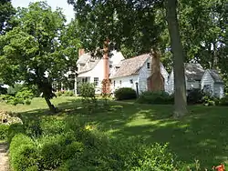 Maidstone |
June 21, 1971 (#71000370) |
Chesapeake Beach Rd. 38°44′05″N 76°37′38″W |
Owings | |
| 14 | Middleham Chapel |  Middleham Chapel |
February 20, 1975 (#75000870) |
1 mile southeast of Lusby on Maryland Route 4 38°23′56″N 76°26′13″W |
Lusby | |
| 15 | Morgan Hill Farm | 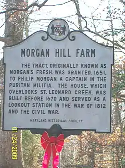 Morgan Hill Farm |
April 3, 1976 (#76000981) |
Sollers Rd., west of Lusby 38°24′35″N 76°28′46″W |
Lusby | |
| 16 | Patterson's Archeological District |  Patterson's Archeological District |
April 12, 1982 (#82002808) |
Address Restricted |
Wallville | |
| 17 | Preston-on-the-Patuxent |  Preston-on-the-Patuxent |
October 9, 1974 (#74000943) |
North of Johnstown off Sollers Mill Rd. 38°22′20″N 76°29′06″W |
Johnstown | |
| 18 | Taney Place | 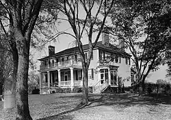 Taney Place |
September 22, 1972 (#72000570) |
South of Adelina on Maryland Route 508 38°27′43″N 76°36′19″W |
Adelina | |
| 19 | WM. B. TENNISON (Chesapeake Bay Bugeye) | 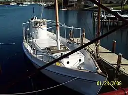 WM. B. TENNISON (Chesapeake Bay Bugeye) |
March 27, 1980 (#80001799) |
Calvert Marine Museum 38°19′30″N 76°27′39″W |
Solomons | |
| 20 | Willow Glenn | July 2, 1973 (#73000906) |
Northwest of Barstow on Barstow Rd. 38°32′44″N 76°38′06″W |
Barstow |
See also
| Wikimedia Commons has media related to National Register of Historic Places in Calvert County, Maryland. |
References
- The latitude and longitude information provided in this table was derived originally from the National Register Information System, which has been found to be fairly accurate for about 99% of listings. Some locations in this table may have been corrected to current GPS standards.
- "National Register of Historic Places: Weekly List Actions". National Park Service, United States Department of the Interior. Retrieved on January 29, 2021.
- Numbers represent an alphabetical ordering by significant words. Various colorings, defined here, differentiate National Historic Landmarks and historic districts from other NRHP buildings, structures, sites or objects.
- "National Register Information System". National Register of Historic Places. National Park Service. April 24, 2008.
- The eight-digit number below each date is the number assigned to each location in the National Register Information System database, which can be viewed by clicking the number.
| Topics |  | |
|---|---|---|
| Lists by county | ||
| Lists by city | ||
| Other lists | ||
| ||
Municipalities and communities of Calvert County, Maryland, United States | ||
|---|---|---|
| Towns | | |
| CDPs | ||
| Other communities | ||
| Ghost town | ||
| ||
This article is issued from Wikipedia. The text is licensed under Creative Commons - Attribution - Sharealike. Additional terms may apply for the media files.