National Register of Historic Places listings in Washington County, Maryland
This is a list of the National Register of Historic Places listings in Washington County, Maryland.
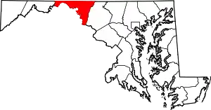
Location of Washington County in Maryland
This is intended to be a complete list of the properties and districts on the National Register of Historic Places in Washington County, Maryland, United States. Latitude and longitude coordinates are provided for many National Register properties and districts; these locations may be seen together in a map.[1]
There are 103 properties and districts listed on the National Register in the county, including 3 National Historic Landmarks.
| Allegany - Anne Arundel - Baltimore (city) - Baltimore County - Calvert - Caroline - Carroll - Cecil - Charles - Dorchester - Frederick - Garrett - Harford - Howard - Kent - Montgomery - Prince George's - Queen Anne's - Somerset - St. Mary's - Talbot - Washington - Wicomico - Worcester |
- This National Park Service list is complete through NPS recent listings posted February 5, 2021.[2]
Current listings
| [3] | Name on the Register[4] | Image | Date listed[5] | Location | City or town | Description |
|---|---|---|---|---|---|---|
| 1 | Antietam Furnace Complex Archeological Site | August 25, 1983 (#83002963) |
Address Restricted |
Hagerstown | ||
| 2 | Antietam Hall |  Antietam Hall |
September 24, 1979 (#79003269) |
525 Indian Lane 39°38′12″N 77°40′55″W |
Hagerstown | |
| 3 | Antietam Iron Furnace Site and Antietam Village | 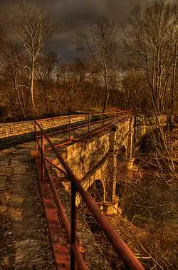 Antietam Iron Furnace Site and Antietam Village |
June 26, 1975 (#75000149) |
Confluence of Antietam Creek and the Potomac River 39°25′01″N 77°44′33″W |
Antietam | |
| 4 | Antietam National Battlefield | 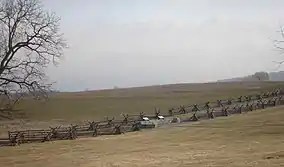 Antietam National Battlefield |
October 15, 1966 (#66000038) |
North of Sharpsburg off Maryland Route 45 39°27′04″N 77°41′09″W |
Sharpsburg | Civil War battlefield site. |
| 5 | B&O Bridge | .jpg.webp) B&O Bridge |
November 23, 1977 (#77000704) |
Northwest of Keedysville over Antietam Creek 39°30′15″N 77°42′49″W |
Keedysville | |
| 6 | B & O Railroad Potomac River Crossing | 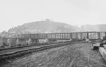 B & O Railroad Potomac River Crossing |
February 14, 1978 (#78001484) |
At the confluence of the Shenandoah and Potomac rivers 39°19′27″N 77°43′43″W |
Harpers Ferry | |
| 7 | Baker Farm | October 19, 1978 (#78001485) |
North of Keedysville off Maryland Route 34 39°29′53″N 77°41′42″W |
Keedysville | ||
| 8 | Bell-Varner House |  Bell-Varner House |
September 24, 1979 (#79003271) |
Southeast of Leitersburg on Unger Rd. 39°40′04″N 77°36′26″W |
Leitersburg | |
| 9 | Boonsboro Historic District |  Boonsboro Historic District |
December 23, 2005 (#05001431) |
Main St., Potomac St., St. Paul St., High St., Lakin Ave., Center St., Park Dr., Park Ln, Park View, and Young Ave. 39°30′22″N 77°39′09″W |
Boonsboro | |
| 10 | Bowman House | 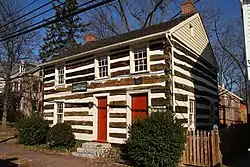 Bowman House |
April 29, 1977 (#77000702) |
323 N. Main St. 39°30′42″N 77°39′18″W |
Boonsboro | |
| 11 | Brightwood |  Brightwood |
July 30, 1974 (#74000973) |
North of Hagerstown off Maryland Route 60, 2 miles (3.2 km) north of Paramont 39°41′56″N 77°40′43″W |
Hagerstown | |
| 12 | Cedar Grove | August 27, 1999 (#99000984) |
15435 Dellinger Rd. 39°32′07″N 77°50′07″W |
Williamsport | ||
| 13 | William Chapline House |  William Chapline House |
October 8, 1976 (#76001020) |
109 W. Main St. 39°27′29″N 77°44′59″W |
Sharpsburg | |
| 14 | Chesapeake and Ohio Canal National Historical Park | 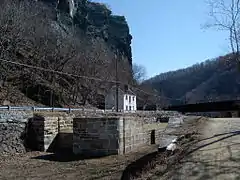 Chesapeake and Ohio Canal National Historical Park |
October 15, 1966 (#66000036) |
Bordering the Potomac River from Georgetown, Washington, D.C. to Cumberland, Maryland 39°35′53″N 77°49′40″W |
Antietam, Cedar Grove, Hancock, and Sharpsburg | |
| 15 | Robert Clagett Farm | June 5, 1999 (#99000132) |
Garrett's Mill Rd. 39°21′03″N 77°41′06″W |
Knoxville | ||
| 16 | Colonial Theatre | 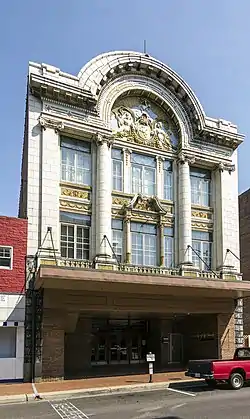 Colonial Theatre |
August 2, 1978 (#78001478) |
12-14 S. Potomac St. 39°38′28″N 77°43′13″W |
Hagerstown | |
| 17 | Cool Hollow Home |  Cool Hollow Home |
December 17, 2018 (#100003253) |
9302 Old National Pike 39°34′08″N 77°41′23″W |
Hagerstown | |
| 18 | Ditto Knolls |  Ditto Knolls |
July 12, 1976 (#76001014) |
East of Hagerstown on Landis Rd. 39°36′23″N 77°39′45″W |
Hagerstown | |
| 19 | Daniel Donnelly House | December 24, 2003 (#03001333) |
14906 Falling Waters Rd. 39°33′23″N 77°51′15″W |
Williamsport | ||
| 20 | Dorsey-Palmer House | 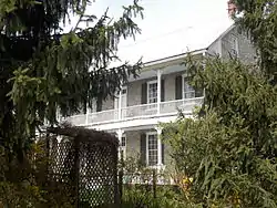 Dorsey-Palmer House |
April 15, 1978 (#78001479) |
North of Hagerstown on Maryland Route 60 39°40′41″N 77°41′02″W |
Hagerstown | |
| 21 | Doub Farm | November 15, 1978 (#78001486) |
North of Keedysville 39°29′37″N 77°41′51″W |
Keedysville | ||
| 22 | Doub's Mill Historic District | 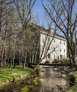 Doub's Mill Historic District |
October 1, 1979 (#79003270) |
Southwest of Beaver Creek on Beaver Creek Rd. 39°34′43″N 77°39′18″W |
Beaver Creek | |
| 23 | Elliot-Bester House |  Elliot-Bester House |
May 2, 1975 (#75000924) |
205-207 S. Potomac St. 39°38′19″N 77°43′22″W |
Hagerstown | |
| 24 | Elmwood |  Elmwood |
December 26, 2012 (#12001085) |
16311 Kendle Rd. 39°35′10″N 77°48′06″W |
Williamsport | |
| 25 | Joseph Fiery House | December 27, 2002 (#02001588) |
15107 Hicksville Rd. 39°42′06″N 77°50′49″W |
Clear Spring | ||
| 26 | Fort Frederick | .jpg.webp) Fort Frederick |
November 7, 1973 (#73000939) |
Southeast of Big Pool near the junction of Maryland Routes 44 and 56 39°36′33″N 78°00′12″W |
Big Pool | |
| 27 | Jacob M. Funk Farm |  Jacob M. Funk Farm |
October 14, 2010 (#10000829) |
21116 Black Rock Road 39°34′49″N 77°37′58″W |
Hagerstown | |
| 28 | Funkstown Historic District | 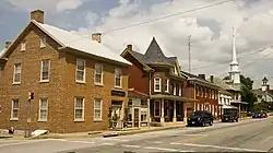 Funkstown Historic District |
September 8, 2000 (#00001050) |
Roughly bounded by Antietam Creek, U.S. Route 40A, Stouffer Ave., and High St. 39°36′30″N 77°42′36″W |
Funkstown | |
| 29 | Garden Hill | 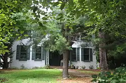 Garden Hill |
December 27, 2002 (#02001590) |
1251 Frederick St. 39°36′49″N 77°42′45″W |
Hagerstown | |
| 30 | Geeting Farm | 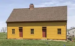 Geeting Farm |
November 25, 1977 (#77000705) |
South of Keedysville at Geeting and Dog Rds. 39°28′40″N 77°41′54″W |
Keedysville | |
| 31 | Good-Hartle Farm |  Good-Hartle Farm |
December 9, 1999 (#99001543) |
13357 Little Antietam Rd. 39°40′52″N 77°37′41″W |
Hagerstown | |
| 32 | Good-Reilly House | 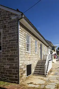 Good-Reilly House |
December 30, 2002 (#02001591) |
107 E. Main St. 39°27′30″N 77°44′55″W |
Sharpsburg | |
| 33 | Hager House | 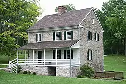 Hager House |
November 5, 1974 (#74000974) |
19 Key St. 39°38′22″N 77°43′50″W |
Hagerstown | |
| 34 | William Hagerman Farmstead | December 27, 2002 (#02001592) |
7207 Dam #4 Rd. 39°30′41″N 77°49′00″W |
Sharpsburg | ||
| 35 | Hagerstown Armory | 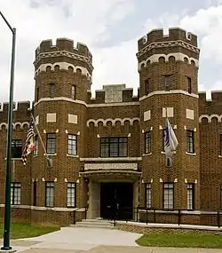 Hagerstown Armory |
September 25, 1985 (#85002673) |
328 N. Potomac St. 39°38′47″N 77°43′00″W |
Hagerstown | |
| 36 | Hagerstown Charity School |  Hagerstown Charity School |
December 16, 1982 (#82001601) |
102 E. Washington St. 39°38′26″N 77°43′05″W |
Hagerstown | |
| 37 | Hagerstown City Park Historic District |  Hagerstown City Park Historic District |
July 5, 1990 (#90001017) |
Roughly bounded by W. Howard St., Guilford Ave., Memorial, S. Walnut St., and the Norfolk & Western railroad line 39°38′10″N 77°43′50″W |
Hagerstown | |
| 38 | Hagerstown Commercial Core Historic District |  Hagerstown Commercial Core Historic District |
January 17, 1983 (#83002964) |
Potomac, Washington, Franklin, Antietam, Summit, and Jonathan Sts. 39°38′33″N 77°43′18″W |
Hagerstown | |
| 39 | Hagerstown Historic District |  Hagerstown Historic District |
February 2, 1994 (#93001551) |
Roughly bounded by Prospect and Cannon Aves., Memorial Boulevard, and the CSX railroad line 39°38′23″N 77°43′06″W |
Hagerstown | |
| 40 | Harpers Ferry National Historical Park | 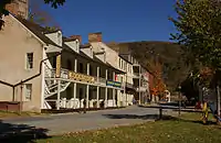 Harpers Ferry National Historical Park |
October 15, 1966 (#66000041) |
At the confluence of the Shenandoah and Potomac rivers 39°18′59″N 77°43′09″W |
Harpers Ferry | |
| 41 | Joseph C. Hays House | 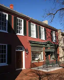 Joseph C. Hays House |
December 12, 2006 (#06001125) |
103-105 W. Main St. 39°27′30″N 77°44′58″W |
Sharpsburg | |
| 42 | Jacob Highbarger House | 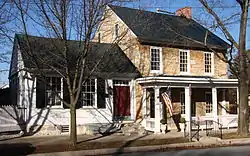 Jacob Highbarger House |
December 27, 2002 (#02001593) |
201 W. Main St. 39°27′27″N 77°45′06″W |
Sharpsburg | |
| 43 | Hills, Dales and The Vinyard | 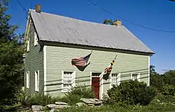 Hills, Dales and The Vinyard |
December 1, 2000 (#00001460) |
16 Dogstreet Rd. 39°29′00″N 77°42′25″W |
Keedysville | |
| 44 | Hitt's Mill and Houses | 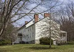 Hitt's Mill and Houses |
April 12, 1979 (#79001147) |
West of Keedysville off Maryland Route 34 39°29′06″N 77°42′44″W |
Keedysville | |
| 45 | Hoffman Farm | 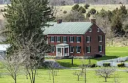 Hoffman Farm |
October 10, 1997 (#97001183) |
18651 Keedysville Rd. 39°29′53″N 77°43′19″W |
Keedysville | |
| 46 | Hogmire-Berryman Farm | March 28, 1980 (#80001842) |
North of Spielman off Maryland Route 63 39°32′32″N 77°46′00″W |
Spielman | ||
| 47 | Houses At 16-22 East Lee Street |  Houses At 16-22 East Lee Street |
November 25, 1977 (#77000703) |
16-22 E. Lee St. 39°38′12″N 77°43′19″W |
Hagerstown | |
| 48 | Huckleberry Hall | December 28, 1990 (#90001994) |
Charles Mill Rd., west of its junction with Maryland Route 64 39°41′18″N 77°35′27″W |
Leitersburg | ||
| 49 | Ingram-Schipper Farm | September 24, 1979 (#79003259) |
Mapleville Road (MD 66), North of Boonsboro 39°33′46″N 77°39′37″W |
Boonsboro | ||
| 50 | Kennedy Farm |  Kennedy Farm |
November 7, 1973 (#73000941) |
Chestnut Grove Rd. 39°22′47″N 77°42′56″W |
Samples Manor | Known as John Brown's Headquarters. |
| 51 | Keedy House |  Keedy House |
July 25, 1974 (#74000972) |
Northwest of Boonsboro off U.S. Route 40A on Barnes Rd. 39°32′22″N 77°41′55″W |
Boonsboro | |
| 52 | Keedysville Historic District | 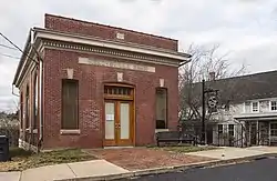 Keedysville Historic District |
October 26, 2001 (#01001183) |
Along Main St. 39°29′12″N 77°41′56″W |
Keedysville | |
| 53 | Kefauver Place | August 26, 2005 (#05000908) |
20515 Park Hall Rd. 39°27′01″N 77°39′14″W |
Rohrersville | ||
| 54 | Lantz-Zeigler House | 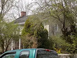 Lantz-Zeigler House |
October 8, 1998 (#98001231) |
21000 Leitersburg Pike 39°41′20″N 77°38′17″W |
Hagerstown | |
| 55 | Lehman's Mill Historic District |  Lehman's Mill Historic District |
January 4, 1991 (#90001945) |
Lehman's Mill Rd. between Marsh Pike and Marsh Run 39°42′41″N 77°40′34″W |
Hagerstown | |
| 56 | Leitersburg Historic District |  Leitersburg Historic District |
December 19, 2003 (#03001295) |
Leitersburg-Smithsburg Rd., Leiter St., Leiter's Mill Rd., and Ringgold St. 39°41′42″N 77°37′15″W |
Leitersburg | |
| 57 | Long Meadows |  Long Meadows |
September 1, 1978 (#78001480) |
North of Hagerstown on Marsh Pike 39°41′41″N 77°41′08″W |
Hagerstown | |
| 58 | Magnolia Plantation | June 18, 1975 (#75000926) |
Northwest of Knoxville off Sandy Hook Rd. 39°20′57″N 77°41′34″W |
Knoxville | ||
| 59 | Mannheim | September 25, 1979 (#79003260) |
San Mar Rd. 39°33′19″N 77°37′51″W |
San Mar | ||
| 60 | The Maples | February 24, 1975 (#75000927) |
2 miles (3.2 km) southwest of Smithsburg on Maryland Route 66 39°37′23″N 77°39′38″W |
Smithsburg | ||
| 61 | Marsh Mills | November 22, 1996 (#96001375) |
17426 and 17432 Spielman Rd. 39°32′22″N 77°45′44″W |
Fairplay | ||
| 62 | Maryland Theatre | 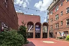 Maryland Theatre |
November 13, 1976 (#76001015) |
21-23 S. Potomac St. 39°38′29″N 77°43′17″W |
Hagerstown | |
| 63 | Henry McCauley Farm |  Henry McCauley Farm |
June 29, 1976 (#76001016) |
East of Hagerstown on Mt. Aetna Rd. 39°36′53″N 77°39′46″W |
Hagerstown | |
| 64 | Mount Airy | Mount Airy |
July 10, 1986 (#86001550) |
Maryland Route 34 39°26′55″N 77°46′04″W |
Sharpsburg | |
| 65 | Nicodemus Mill Complex | August 2, 2001 (#01000821) |
20019 Nicodemus Mill Rd. 39°28′34″N 77°40′24″W |
Keedysville | ||
| 66 | Oak Hill Historic District | 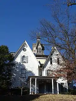 Oak Hill Historic District |
September 18, 1987 (#87001574) |
Roughly bounded by W. Irvin, Potomac, and Prospect Aves. and Forest Dr. 39°39′18″N 77°42′38″W |
Hagerstown | |
| 67 | Old Forge Farm |  Old Forge Farm |
November 7, 1979 (#79001145) |
East of Hagerstown 39°40′02″N 77°38′58″W |
Hagerstown | |
| 68 | Old National Pike Milestones |  Old National Pike Milestones |
November 27, 1975 (#75002107) |
Maryland Routes 44 and 165, U.S. Route 40, Alternate U.S. Route 40, and Scenic U.S. Route 40 39°25′13″N 77°16′01″W |
Hancock | |
| 69 | Old Washington County Library | 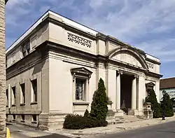 Old Washington County Library |
October 2, 1978 (#78001481) |
21 Summit Ave. 39°38′34″N 77°43′24″W |
Hagerstown | |
| 70 | Packhouse Ford |  Packhouse Ford |
June 15, 2015 (#15000349) |
Potomac R. at Canal Rd. 39°25′51″N 77°46′35″W |
Sharpsburg | A historic river crossing of the Potomac River. |
| 71 | Paradise Manor |  Paradise Manor |
March 31, 1978 (#78001482) |
North of Hagerstown at 2550 Paradise Dr. 39°41′49″N 77°42′03″W |
Hagerstown | |
| 72 | Piper House | 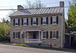 Piper House |
October 28, 1999 (#99001279) |
200 E. Main St. 39°27′31″N 77°44′45″W |
Sharpsburg | |
| 73 | Plumb Grove |  Plumb Grove |
December 7, 2011 (#11000882) |
12654 Broadfording Rd. 39°39′40″N 77°56′11″W |
Clear Spring | |
| 74 | Potomac-Broadway Historic District | 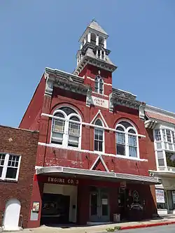 Potomac-Broadway Historic District |
December 12, 1990 (#90001804) |
Roughly Potomac St. and Oak Hill Ave. from Franklin St. to Maple Ave., and North Ave. and Broadway from Park Pl. to Mulberry 39°38′54″N 77°42′53″W |
Hagerstown | |
| 75 | Potomac Mills | Potomac Mills |
February 5, 2014 (#13001166) |
River & Trough Rds. 39°25′50″N 77°46′53″W |
Shepherdstown | |
| 76 | Price-Miller House | 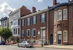 Price-Miller House |
May 24, 1976 (#76001018) |
131-135 W. Washington St. 39°38′37″N 77°43′25″W |
Hagerstown | |
| 77 | Rockland Farm | 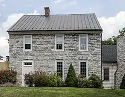 Rockland Farm |
July 21, 1978 (#78001483) |
728 Antietam Dr. 39°39′21″N 77°41′20″W |
Hagerstown | |
| 78 | Rockledge |  Rockledge |
December 18, 2003 (#03001292) |
13535 Foxfire Ln. 39°41′20″N 77°36′45″W |
Hagerstown | |
| 79 | Rohrer House |  Rohrer House |
November 7, 1979 (#79001146) |
East of Hagerstown 39°39′25″N 77°39′40″W |
Hagerstown | |
| 80 | Rose Hill | 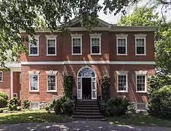 Rose Hill |
April 11, 1973 (#73000942) |
0.5 miles (0.80 km) south of Williamsport on Maryland Route 63 39°34′41″N 77°49′08″W |
Williamsport | |
| 81 | Search Well | January 17, 1983 (#83002965) |
Southeast of Burtner on Manor Church Rd. 39°31′12″N 77°42′49″W |
Burtner | ||
| 82 | Sharpsburg Historic District | Sharpsburg Historic District |
December 24, 2008 (#08001218) |
E. and W. Chapline, Antietam, and High Sts. and N. and S. Church, Mechanic, Hall, and Potomac Sts. 39°27′27″N 77°44′56″W |
Sharpsburg | |
| 83 | Snively Farm | September 24, 1979 (#79001144) |
North of Eakles Mills on Mt. Briar Rd. 39°28′13″N 77°41′26″W |
Eakles Mills | ||
| 84 | South Prospect Street Historic District |  South Prospect Street Historic District |
October 1, 1979 (#79003261) |
18-278 S. Prospect St. 39°38′29″N 77°43′35″W |
Hagerstown | |
| 85 | Sprechers Mill House | January 5, 1978 (#78001487) |
Northeast of Williamsport on Hopewell Rd. 39°37′02″N 77°47′40″W |
Williamsport | ||
| 86 | Springfield Farm | 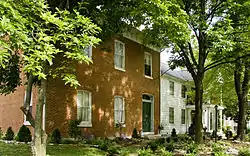 Springfield Farm |
July 30, 1974 (#74000977) |
South of U.S. Route 11 39°35′48″N 77°48′57″W |
Williamsport | |
| 87 | St. Mark's Episcopal Church-Lappans | 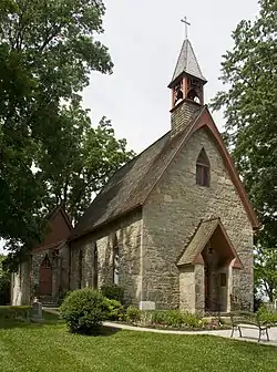 St. Mark's Episcopal Church-Lappans |
August 5, 1999 (#99000931) |
18313 Lappans Rd. 39°33′03″N 77°44′03″W |
Boonsboro | |
| 88 | Tammany |  Tammany |
September 24, 1979 (#79003262) |
Northeast of Williamsport off U.S. Route 11 39°36′39″N 77°47′44″W |
Williamsport | |
| 89 | Tolson's Chapel |  Tolson's Chapel |
October 21, 2008 (#08001012) |
111 E. High St. 39°27′22″N 77°44′47″W |
Sharpsburg | Designated a National Historic Landmark in 2021. |
| 90 | Trovinger Mill |  Trovinger Mill |
April 21, 1975 (#75000925) |
3 miles (4.8 km) east of Hagerstown on Trovinger Mill Rd. and Antietam Creek 39°39′09″N 77°39′56″W |
Hagerstown | |
| 91 | Valentia |  Valentia |
June 27, 1974 (#74000975) |
South of Hagerstown on Poffenberger Rd. off Maryland Route 65 39°35′42″N 77°42′41″W |
Hagerstown | |
| 92 | Washington County Courthouse | 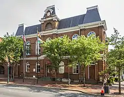 Washington County Courthouse |
December 24, 1974 (#74000976) |
W. Washington St. and Summit Ave. 39°38′34″N 77°43′22″W |
Hagerstown | |
| 93 | Washington Monument |  Washington Monument |
November 3, 1972 (#72000588) |
Washington Monument State Park 39°29′59″N 77°37′28″W |
Boonsboro | |
| 94 | Western Maryland Railroad Right-of-Way, Milepost 126 to Milepost 160 |  Western Maryland Railroad Right-of-Way, Milepost 126 to Milepost 160 |
July 23, 1981 (#81000078) |
Milepost 126 to Milepost 160 39°33′53″N 78°32′08″W |
Woodmont | |
| 95 | Western Maryland Railway Station |  Western Maryland Railway Station |
April 22, 1976 (#76001019) |
Burhans Boulevard 39°38′44″N 77°43′34″W |
Hagerstown | |
| 96 | Western Maryland Railway Steam Locomotive No. 202 | Western Maryland Railway Steam Locomotive No. 202 |
June 7, 1984 (#84001884) |
City Park 39°38′06″N 77°44′06″W |
Hagerstown | |
| 97 | Williamsport Historic District |  Williamsport Historic District |
October 26, 2001 (#01001184) |
Roughly bounded by the Chesapeake and Ohio Canal, Conococheague Creek, Springfield Ln., and W. Frederick St. 39°35′58″N 77°49′15″W |
Williamsport | |
| 98 | The Willows |  The Willows |
February 23, 1973 (#73000940) |
Southwest of Cavetown on Maryland Route 66 39°37′34″N 77°36′12″W |
Cavetown | |
| 99 | Wilson School |  Wilson School |
October 30, 1998 (#98001293) |
Rufus Wilson Rd. 39°39′23″N 77°51′11″W |
Clear Spring | |
| 100 | Wilson's Bridge | 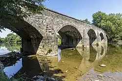 Wilson's Bridge |
March 15, 1982 (#82002822) |
U.S. Route 40 39°39′27″N 77°50′53″W |
Hagerstown | |
| 101 | Rufus Wilson Complex |  Rufus Wilson Complex |
December 6, 1996 (#96001416) |
14293 Rufus Wilson Rd. 39°39′22″N 77°51′06″W |
Clear Spring | |
| 102 | Wilson-Miller Farm | May 23, 1980 (#80001841) |
Southeast of Sharpsburg 39°26′24″N 77°45′57″W |
Sharpsburg | ||
| 103 | Woburn Manor | September 13, 2000 (#00001052) |
7661 Dam #4 Rd. 39°31′24″N 77°48′45″W |
Sharpsburg |
See also
| Wikimedia Commons has media related to National Register of Historic Places in Washington County, Maryland. |
References
- The latitude and longitude information provided in this table was derived originally from the National Register Information System, which has been found to be fairly accurate for about 99% of listings. Some locations in this table may have been corrected to current GPS standards.
- "National Register of Historic Places: Weekly List Actions". National Park Service, United States Department of the Interior. Retrieved on February 5, 2021.
- Numbers represent an alphabetical ordering by significant words. Various colorings, defined here, differentiate National Historic Landmarks and historic districts from other NRHP buildings, structures, sites or objects.
- "National Register Information System". National Register of Historic Places. National Park Service. April 24, 2008.
- The eight-digit number below each date is the number assigned to each location in the National Register Information System database, which can be viewed by clicking the number.
| Topics | 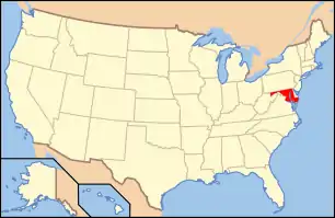 | |
|---|---|---|
| Lists by county | ||
| Lists by city | ||
| Other lists | ||
| ||
This article is issued from Wikipedia. The text is licensed under Creative Commons - Attribution - Sharealike. Additional terms may apply for the media files.