National Register of Historic Places listings in Middletown, Connecticut
This is a list of properties and historic districts in Middletown, Connecticut that are listed on the National Register of Historic Places. There are 33 in the city, which is a large portion of all NRHP listings in Middlesex County. There are 81 others in the county, listed here.
The Middletown listings are:
Current listings
| [1] | Name on the Register[2] | Image | Date listed[3] | Location | City or town | Description |
|---|---|---|---|---|---|---|
| 1 | Alsop House | 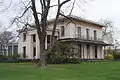 Alsop House |
October 6, 1970 (#70000686) |
301 High St. 41°33′30″N 72°39′22″W |
Middletown | Stately mansion built in "Greek-Tuscan Italianate" style in 1838-39, now owned by Wesleyan University. Designated a National Historic Landmark in 2009. |
| 2 | Arrawanna Bridge | 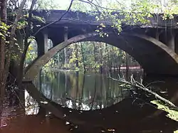 Arrawanna Bridge |
September 29, 2004 (#04001092) |
Berlin St. at the Coginchaug River 41°33′46″N 72°40′00″W |
Middletown | An early reinforced concrete bridge, of elegant open spandrel design, blocked from use and deteriorating as of 2004 nomination. |
| 3 | Broad Street Historic District |  Broad Street Historic District |
August 25, 1988 (#88001319) |
Roughly bounded by High, Washington, Broad and Church Sts. 41°33′29″N 72°39′10″W |
Middletown | |
| 4 | Church of the Holy Trinity and Rectory |  Church of the Holy Trinity and Rectory |
August 14, 1979 (#79002615) |
381 Main St. and 144 Broad St. 41°33′40″N 72°39′06″W |
Middletown | |
| 5 | Coite-Hubbard House | 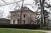 Coite-Hubbard House |
December 20, 1978 (#78002846) |
269 High St. 41°33′26″N 72°39′20″W |
Middletown | |
| 6 | Connecticut General Hospital for the Insane | 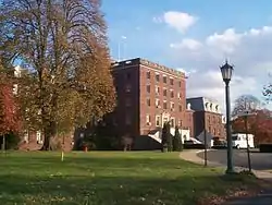 Connecticut General Hospital for the Insane |
August 29, 1985 (#85001920) |
Silver St. E. of Eastern Dr. 41°33′10″N 72°37′47″W |
Middletown | |
| 7 | Connecticut Valley Hospital Cemetery | 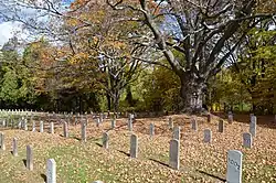 Connecticut Valley Hospital Cemetery |
August 2, 2018 (#100002718) |
S of jct. of Silvermine Rd. & O'Brien Dr. 41°33′12″N 72°37′11″W |
Middletown | |
| 8 | The Eclectic House | 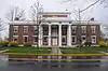 The Eclectic House |
January 2, 2013 (#12001111) |
200 High St., Wesleyan University 41°33′18″N 72°39′15″W |
Middletown | |
| 9 | Highland Historic District | 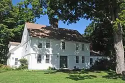 Highland Historic District |
June 28, 1982 (#82003770) |
Atkins St. and Country Club Rd. 41°34′05″N 72°44′16″W |
Middletown | |
| 10 | Nehemiah Hubbard House | 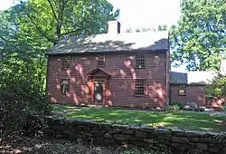 Nehemiah Hubbard House |
May 11, 1982 (#82003771) |
Laurel Grove Rd. and Wadsworth St. 41°32′17″N 72°40′52″W |
Middletown | |
| 11 | Main Street Historic District (Middletown) | 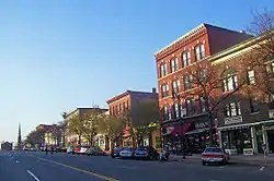 Main Street Historic District (Middletown) |
June 30, 1983 (#83001275) |
Roughly Main St. between College and Hartford Ave. 41°33′45″N 72°38′56″W |
Middletown | |
| 12 | Metro South Historic District | 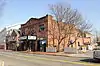 Metro South Historic District |
January 24, 1980 (#80004064) |
Main and College Sts. 41°33′27″N 72°38′49″W |
Middletown | |
| 13 | Middletown Alms House | .jpg.webp) Middletown Alms House |
April 29, 1982 (#82003772) |
53 Warwick St. 41°32′56″N 72°39′09″W |
Middletown | |
| 14 | Middletown South Green Historic District | 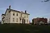 Middletown South Green Historic District |
August 12, 1975 (#75001922) |
Union Park area, on S. Main, Crescent, Pleasant, and Church Sts. 41°33′21″N 72°38′56″W |
Middletown | |
| 15 | Old Middletown High School | 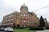 Old Middletown High School |
August 23, 1985 (#85001826) |
Pearl and Court Sts. 41°33′30″N 72°39′13″W |
Middletown | |
| 16 | Jacob Pledger House | 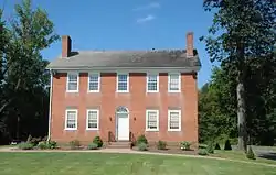 Jacob Pledger House |
March 15, 1982 (#82003773) |
717 Newfield St. 41°34′43″N 72°40′22″W |
Middletown | |
| 17 | Plumb House | 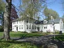 Plumb House |
December 1, 1978 (#78002848) |
West of Middletown at 872 Westfield St. 41°33′49″N 72°42′06″W |
Middletown | |
| 18 | Russell Company Upper Mill | 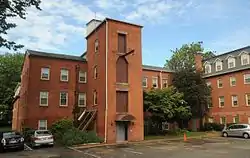 Russell Company Upper Mill |
February 6, 1986 (#86000150) |
475 E. Main St. 41°32′37″N 72°38′20″W |
Middletown | |
| 19 | Edward Augustus Russell House | 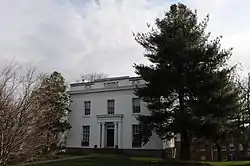 Edward Augustus Russell House |
April 29, 1982 (#82004336) |
318 High St. 41°33′32″N 72°39′20″W |
Middletown | Later ΚΝΚ fraternity, now offices of University Relations, Wesleyan University |
| 20 | Samuel Wadsworth Russell House | 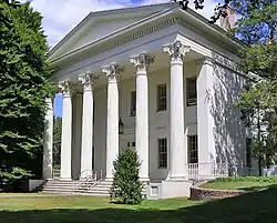 Samuel Wadsworth Russell House |
October 6, 1970 (#70000688) |
350 High St. 41°33′37″N 72°39′20″W |
Middletown | Greek revival mansion, designed by Ithiel Town; now part of Wesleyan University. |
| 21 | Saint Luke's Home for Destitute and Aged Women | 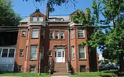 Saint Luke's Home for Destitute and Aged Women |
April 29, 1982 (#82004337) |
135 Pearl St. 41°33′42″N 72°39′17″W |
Middletown | |
| 22 | Sanseer Mill | Sanseer Mill |
July 31, 1986 (#86002101) |
215 E. Main St. 41°32′59″N 72°38′31″W |
Middletown | |
| 23 | Starr Mill | 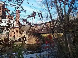 Starr Mill |
December 14, 1993 (#93001379) |
Junction of Middlefield St. and Beverly Heights 41°32′55″N 72°41′28″W |
Middletown | |
| 24 | Starr Mill Road Bridge | Starr Mill Road Bridge |
December 10, 1993 (#93001344) |
Starr Mill Rd. across the Cochinaug River 41°32′56″N 72°40′38″W |
Middletown | |
| 25 | Town Farms Inn | 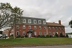 Town Farms Inn |
May 4, 1979 (#79002614) |
Spring St. at River Rd. 41°33′28″N 72°37′20″W |
Middletown | |
| 26 | U.S. Post Office | 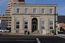 U.S. Post Office |
April 12, 1982 (#82004338) |
291 Main St. 41°33′36″N 72°39′01″W |
Middletown | |
| 27 | Wadsworth Estate Historic District | 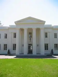 Wadsworth Estate Historic District |
July 25, 1996 (#96000775) |
15, 30, 33, 59, 73, and 89 Laurel Grove Rd., Wadsworth Falls State Park, and 421 Wadsworth St. 41°32′02″N 72°40′44″W |
Middletown | |
| 28 | Washington Street Historic District | 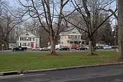 Washington Street Historic District |
May 9, 1985 (#85001018) |
Roughly bounded by Washington and Main Sts., Washington Terrace, and Vine St. 41°33′41″N 72°39′31″W |
Middletown | |
| 29 | Seth Wetmore House | 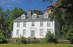 Seth Wetmore House |
September 10, 1970 (#70000689) |
CT 66 and Camp Rd. 41°33′09″N 72°41′19″W |
Middletown | |
| 30 | Wilcox, Crittenden Mill |  Wilcox, Crittenden Mill |
December 3, 1986 (#86003349) |
234-315 S. Main St., Pameacha, and Highlands Aves. 41°32′54″N 72°39′19″W |
Middletown | |
| 31 | Captain Benjamin Williams House | 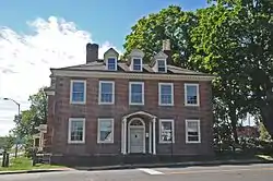 Captain Benjamin Williams House |
December 1, 1978 (#09000143) |
27 Washington St., 41°33′47″N 72°38′54″W |
Middletown | |
| 32 | Woodrow Wilson High School | 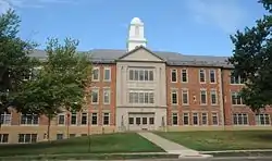 Woodrow Wilson High School |
August 6, 1986 (#86002270) |
Hunting Hill Ave. and Russell St. 41°32′25″N 72°38′57″W |
Middletown | |
| 33 | Xi Chapter, Psi Upsilon Fraternity |  Xi Chapter, Psi Upsilon Fraternity |
November 4, 2009 (#09000870) |
242 High St. 41°33′24″N 72°39′18″W |
Middletown |
References
- Numbers represent an alphabetical ordering by significant words. Various colorings, defined here, differentiate National Historic Landmarks and historic districts from other NRHP buildings, structures, sites or objects.
- "National Register Information System". National Register of Historic Places. National Park Service. March 13, 2009.
- The eight-digit number below each date is the number assigned to each location in the National Register Information System database, which can be viewed by clicking the number.
| Wikimedia Commons has media related to National Register of Historic Places in Middletown, Connecticut. |
| Lists by county |  | |
|---|---|---|
| Lists by city or town | ||
| Other lists | ||
This article is issued from Wikipedia. The text is licensed under Creative Commons - Attribution - Sharealike. Additional terms may apply for the media files.