National Register of Historic Places listings in Oswego County, New York
List of the National Register of Historic Places listings in Oswego County, New York
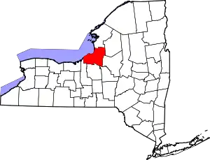
Location of Oswego County in New York
This is intended to be a complete list of properties and districts listed on the National Register of Historic Places in Oswego County, New York. The locations of National Register properties and districts (at least for all showing latitude and longitude coordinates below) may be seen in a map by clicking on "Map of all coordinates".[1] Two properties, the Nash (tugboat) and the New York Barge Canal, are further designated a National Historic Landmark of the United States.
- This National Park Service list is complete through NPS recent listings posted January 29, 2021.[2]
| Albany (Albany) – Allegany – Bronx – Broome – Cattaraugus – Cayuga – Chautauqua – Chemung – Chenango – Clinton – Columbia – Cortland – Delaware – Dutchess (Poughkeepsie, Rhinebeck) – Erie (Buffalo) – Essex – Franklin – Fulton – Genesee – Greene – Hamilton – Herkimer – Jefferson – Kings – Lewis – Livingston – Madison – Monroe (Rochester) – Montgomery – Nassau – New York (Below 14th Street, 14th to 59th Streets, 59th to 110th Streets, Above 110th Street, Islands) – Niagara – Oneida – Onondaga – Ontario – Orange – Orleans – Oswego – Otsego – Putnam – Queens – Rensselaer – Richmond – Rockland – St. Lawrence – Saratoga – Schenectady – Schoharie – Schuyler – Seneca – Steuben – Suffolk – Sullivan – Tioga – Tompkins – Ulster – Warren – Washington – Wayne – Westchester (Northern, Southern, New Rochelle, Peekskill, Yonkers) – Wyoming – Yates |
Listings county-wide
| [3] | Name on the Register | Image | Date listed[4] | Location | City or town | Description |
|---|---|---|---|---|---|---|
| 1 | Amboy District No. 2 Schoolhouse | December 1, 2020 (#100005849) |
398 NY 69 43°22′11″N 75°54′13″W |
East Amboy vicinity | ||
| 2 | Leonard Ames Farmhouse | 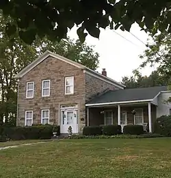 Leonard Ames Farmhouse |
November 14, 1991 (#91001630) |
5707 Main St. 43°27′38″N 76°14′30″W |
Mexico | |
| 3 | Orson Ames House | 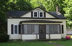 Orson Ames House |
December 4, 2001 (#01001318) |
3339 Main St. 43°27′35″N 76°14′07″W |
Mexico | |
| 4 | Arthur Tavern | Arthur Tavern |
November 14, 1991 (#91001632) |
Junction of Clarke Rd. and NY 16 43°29′42″N 76°14′57″W |
Arthur | |
| 5 | Smith H. Barlow House | November 15, 1988 (#88002214) |
Harwood Dr. 43°38′36″N 76°04′30″W |
Lacona | ||
| 6 | Brosemer Brewery | March 29, 2010 (#10000102) |
472 W. First St. 43°26′45″N 76°30′11″W |
Oswego | ||
| 7 | Buckhout-Jones Building | 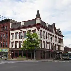 Buckhout-Jones Building |
December 4, 2001 (#01001322) |
5-13 W. Bridge St. 43°27′24″N 76°30′41″W |
Oswego | |
| 8 | Carley's Mills Schoolhouse | 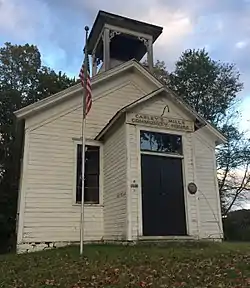 Carley's Mills Schoolhouse |
January 5, 2005 (#04001449) |
County Route 84 43°22′24″N 76°07′02″W |
Hastings | |
| 9 | CHANCELLOR (tugboat) | February 18, 2000 (#00000050) |
Oswego River 43°19′11″N 76°25′03″W |
Fulton | ||
| 10 | Peter Chandler House | 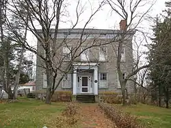 Peter Chandler House |
November 14, 1991 (#91001626) |
5897 Main St. 43°27′35″N 76°13′45″W |
Mexico | |
| 11 | Starr Clark Tin Shop | 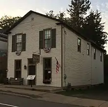 Starr Clark Tin Shop |
December 4, 2001 (#01001323) |
3250 Main St. 43°27′35″N 76°13′43″W |
Mexico | |
| 12 | Edwin W. and Charlotte Clarke House | February 26, 2002 (#02000052) |
80 E. Mohawk St. 43°27′24″N 76°30′02″W |
Oswego | ||
| 13 | Phineas Davis Farmstead |  Phineas Davis Farmstead |
June 20, 1991 (#91000524) |
5422 North Rd. 43°27′55″N 76°13′37″W |
Mexico | |
| 14 | Derrick Boat No. 8 | January 7, 2015 (#14001129) |
1 W. 1st St. 43°27′42″N 76°30′58″W |
Oswego | Built in 1927, it is one of the few surviving steam-powered barges to have worked on the New York State Barge Canal | |
| 15 | John B. and Lydia Edwards House | December 4, 2001 (#01001316) |
144 E. Third St. 43°27′17″N 76°30′16″W |
Oswego | ||
| 16 | First Baptist Church | 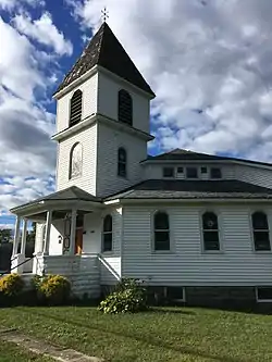 First Baptist Church |
November 15, 1988 (#88002218) |
Harwood Dr. 43°38′38″N 76°04′40″W |
Sandy Creek | |
| 17 | First Congregational Church and Society of Volney | June 29, 2001 (#01000675) |
NY 3 43°20′18″N 76°20′19″W |
Volney | ||
| 18 | First National Bank of Lacona | 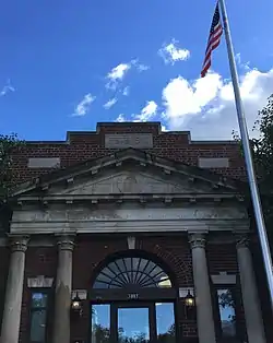 First National Bank of Lacona |
November 15, 1988 (#88002219) |
Harwood Dr. and Salina St. 43°38′36″N 76°04′10″W |
Lacona | |
| 19 | Fort Brewerton | March 7, 1973 (#73001247) |
State and Lansing Sts. 43°14′32″N 76°08′29″W |
Brewerton | ||
| 20 | Fort Ontario | 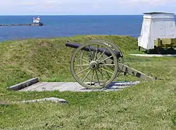 Fort Ontario |
December 18, 1970 (#70000426) |
E. 7th St. and Lake Ontario 43°27′55″N 76°30′31″W |
Oswego | |
| 21 | Fowler-Loomis House | 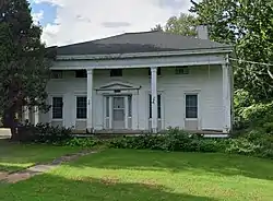 Fowler-Loomis House |
November 14, 1991 (#91001628) |
6022 Main St. 43°27′32″N 76°13′16″W |
Mexico | |
| 22 | Franklin Square Historic District | August 4, 1982 (#82003394) |
Roughly bounded by 3rd, 6th, Van Buren, and Bridge Sts. 43°27′25″N 76°30′59″W |
Oswego | ||
| 23 | Fulton Public Library | January 15, 1999 (#98001616) |
160 S. First St. 43°19′10″N 76°24′59″W |
Fulton | ||
| 24 | Nathan and Clarissa Green House | February 26, 2002 (#02000054) |
98 West Eighth St. 43°27′22″N 76°31′13″W |
Oswego | ||
| 25 | Hamilton Farmstead | 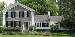 Hamilton Farmstead |
November 18, 1991 (#91001657) |
5644 Hamilton St. 43°28′30″N 76°13′52″W |
Mexico | |
| 26 | Holyoke Cottage | November 15, 1988 (#88002216) |
Seber Shore Rd. 43°38′45″N 76°09′56″W |
Sandy Creek | ||
| 27 | Hunter-Oliphant Block | July 21, 1995 (#95000880) |
215-219 W. First St. 43°27′20″N 76°30′39″W |
Oswego | ||
| 28 | Kingsford Historic District | 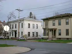 Kingsford Historic District |
January 22, 2014 (#13001114) |
Roughly W. Bridge, W. Mohawk, W. Oneida, W. 4th, and W. 5th Sts. 43°27′12″N 76°30′48″W |
Oswego | |
| 29 | Kingsford House | August 21, 1997 (#97000951) |
150 W. Third St. 43°27′16″N 76°30′47″W |
Oswego | ||
| 30 | Lacona Clock Tower | 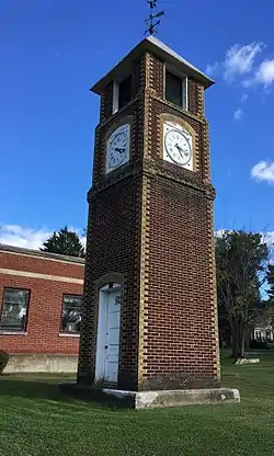 Lacona Clock Tower |
November 15, 1988 (#88002220) |
Harwood Dr. 43°38′36″N 76°04′12″W |
Lacona | |
| 31 | Lacona Railroad Station and Depot | 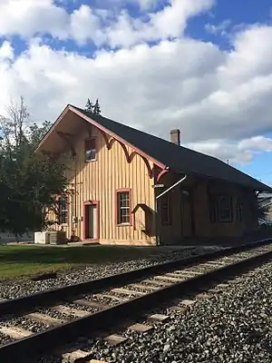 Lacona Railroad Station and Depot |
January 24, 2002 (#01001499) |
11 Park Ave. 43°38′34″N 76°04′13″W |
Lacona | |
| 32 | Hamilton and Rhoda Littlefield House | February 26, 2002 (#02000051) |
44 E. Oneida St. 43°27′25″N 76°30′16″W |
Oswego | ||
| 33 | Market House |  Market House |
June 20, 1974 (#74001292) |
Water St. 43°27′26″N 76°30′39″W |
Oswego | |
| 34 | John and Harriet McKenzie House | December 4, 2001 (#01001314) |
96 W. Eighth St. 43°27′23″N 76°31′13″W |
Oswego | ||
| 35 | Methodist Church | November 15, 1988 (#88002213) |
Harwood Dr. 43°38′37″N 76°04′58″W |
Sandy Creek | ||
| 36 | Mexico Academy and Central School | 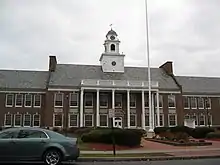 Mexico Academy and Central School |
November 14, 1991 (#91001633) |
3338 Main St. 43°27′37″N 76°14′06″W |
Mexico | |
| 37 | Mexico Octagon Barn | June 20, 1991 (#91000527) |
5276 Ames St. 43°27′08″N 76°14′31″W |
Mexico | ||
| 38 | Mexico Railroad Depot | 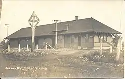 Mexico Railroad Depot |
June 20, 1991 (#91000523) |
5530 Scenic Ave. 43°28′09″N 76°13′57″W |
Mexico | |
| 39 | The Mexico Stone Store | 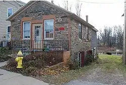 The Mexico Stone Store |
March 23, 2010 (#10000103) |
3201 Main St. 43°27′35″N 76°13′33″W |
Mexico | |
| 40 | Mexico Village Historic District | 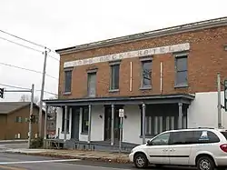 Mexico Village Historic District |
June 20, 1991 (#91000528) |
Main, Jefferson, Church, and Spring Sts. 43°27′29″N 76°13′46″W |
Mexico | |
| 41 | Montcalm Park Historic District | %252C_8_Montcalm_St..jpg.webp) Montcalm Park Historic District |
May 25, 2001 (#01000555) |
Roughly Montcalm St., W. 6th St., W. Schuyler St., and Bronson St. 43°27′35″N 76°31′11″W |
Oswego | |
| 42 | Mount Adnah Cemetery | February 2, 2001 (#01000046) |
706 East Broadway 43°19′14″N 76°24′12″W |
Fulton | ||
| 43 | NASH (harbor tug) | 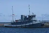 NASH (harbor tug) |
December 4, 1991 (#91002059) |
H. Lee White Marine Museum, West 1st Street Pier 43°27′52″N 76°30′58″W |
Oswego | Last surviving Army ship which served at D-Day |
| 44 | New York State Barge Canal |  New York State Barge Canal |
October 15, 2014 (#14000860) |
Linear across county 43°19′26″N 76°25′08″W |
Cleveland, Constantia, Fulton, Granby, Hastings, Minetta, Phoenix, Schroeppel, Scriba, Volney, West Phoenix | Successor to Erie Canal approved by state voters in early 20th century to compete with railroads. |
| 45 | Northrup-Gilbert House |  Northrup-Gilbert House |
February 4, 2000 (#00000049) |
25 Church St. 43°13′43″N 76°17′49″W |
Phoenix | |
| 46 | Oak Street School | July 3, 2003 (#03000243) |
205 Oak St. 43°18′43″N 76°25′07″W |
Fulton | ||
| 47 | Oswego Armory |  Oswego Armory |
May 19, 1988 (#88000610) |
265 W. First St. 43°27′14″N 76°30′35″W |
Oswego | |
| 48 | Oswego City Hall | 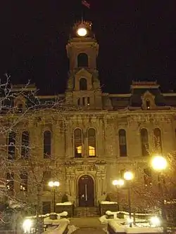 Oswego City Hall |
February 20, 1973 (#73001248) |
W. Oneida St. 43°27′19″N 76°30′42″W |
Oswego | |
| 49 | Oswego City Library | .jpg.webp) Oswego City Library |
September 22, 1971 (#71000554) |
120 E. 2nd St. 43°27′24″N 76°30′25″W |
Oswego | |
| 50 | Oswego County Courthouse | %252C_Oswego%252C_New_York.jpg.webp) Oswego County Courthouse |
December 7, 2000 (#00001418) |
East Bridge St. 43°27′26″N 76°30′22″W |
Oswego | |
| 51 | Oswego and Syracuse Railroad Freight House | November 9, 2017 (#100001806) |
20-24 W. Utica St. 43°27′09″N 76°30′36″W |
Oswego | 1848 stone structure is second oldest surviving rail-related building in the state | |
| 52 | Oswego Theater | 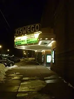 Oswego Theater |
September 19, 1988 (#88001590) |
138 W. Second St. 43°27′21″N 76°30′46″W |
Oswego | |
| 53 | Oswego West Pierhead Lighthouse | 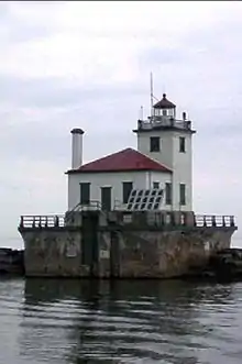 Oswego West Pierhead Lighthouse |
December 1, 2000 (#00001468) |
Lake Ontario, 0.5 miles (0.80 km) north of the Oswego River 43°28′24″N 76°31′02″W |
Oswego | |
| 54 | Oswego Yacht Club | 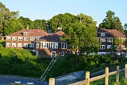 Oswego Yacht Club |
March 23, 2010 (#10000105) |
41 Lake St. 43°27′44″N 76°31′16″W |
Oswego | |
| 55 | Daniel and Miriam Pease House | February 26, 2002 (#02000053) |
361 Cemetery Rd. 43°25′33″N 76°33′37″W |
Oswego | ||
| 56 | Newton M. Pitt House | November 15, 1988 (#88002209) |
8114 Harwood Dr. 43°38′37″N 76°05′00″W |
Sandy Creek | ||
| 57 | Pleasant Lawn Cemetery | October 5, 2005 (#05001125) |
NY 69A 43°24′08″N 76°08′31″W |
Parish | ||
| 58 | Pontiac Hotel | July 21, 1983 (#83001758) |
W. 1st St. 43°26′14″N 76°30′37″W |
Oswego | ||
| 59 | John Wells Pratt House | December 10, 1999 (#99001490) |
177 S. 1st St. 43°19′06″N 76°24′53″W |
Fulton | ||
| 60 | Pulaski Village Historic District | 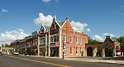 Pulaski Village Historic District |
September 8, 1983 (#83004525) |
Jefferson, Broad, Bridge, Hubbel and Lake Sts. 43°34′01″N 76°07′43″W |
Pulaski | |
| 61 | Red Mill Farm | 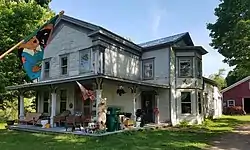 Red Mill Farm |
November 14, 1991 (#91001629) |
7177 Red Mill Rd. 43°25′28″N 76°08′45″W |
Colosse | |
| 62 | Richardson-Bates House | 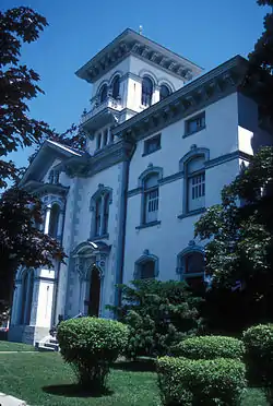 Richardson-Bates House |
September 5, 1975 (#75001220) |
135 E. 3rd St. 43°27′21″N 76°30′16″W |
Oswego | |
| 63 | Riverside Cemetery | August 19, 1993 (#93000854) |
E. River Rd. south of the junction with NY 57 43°25′24″N 76°28′34″W |
Oswego | ||
| 64 | Samuel Sadler House | November 15, 1988 (#88002212) |
N. Main St. 43°38′55″N 76°05′07″W |
Sandy Creek | ||
| 65 | St. James' Church | August 30, 1996 (#96000958) |
North St., junction with Bridge St. 43°14′02″N 75°52′56″W |
Cleveland | ||
| 66 | St. John's Episcopal Church | 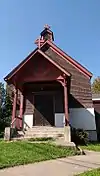 St. John's Episcopal Church |
May 27, 1993 (#93000442) |
670 Main St. 43°13′53″N 76°18′04″W |
Phoenix | |
| 67 | Charles M. Salisbury House | November 15, 1988 (#88002217) |
9089 Church St. 43°38′29″N 76°04′06″W |
Lacona | ||
| 68 | Sandy Creek Historic District | November 15, 1988 (#88002208) |
Junction of Lake Rd. and US 11 43°38′39″N 76°05′10″W |
Sandy Creek | ||
| 69 | Schroeppel House | 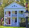 Schroeppel House |
September 9, 1982 (#82003395) |
Morgan Rd. 43°12′20″N 76°13′08″W |
Schroeppel | |
| 70 | Selkirk Lighthouse | .jpg.webp) Selkirk Lighthouse |
March 30, 1979 (#79001618) |
West of Pulaski on Lake Rd. 43°34′28″N 76°12′07″W |
Pulaski | |
| 71 | Sheldon Hall | 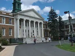 Sheldon Hall |
May 13, 1980 (#80002741) |
Washington Blvd. 43°27′16″N 76°32′12″W |
Oswego | |
| 72 | Matthew Shoecraft House | November 15, 1988 (#88002210) |
Ridge Rd. at Smartville Rd. 43°38′33″N 76°03′45″W |
Lacona | ||
| 73 | Timothy Skinner House | 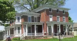 Timothy Skinner House |
June 20, 1991 (#91000526) |
5355 Scenic Ave. 43°27′40″N 76°13′57″W |
Mexico | |
| 74 | Slack Farmstead | November 14, 1991 (#91001627) |
5174 Row Rd. 43°27′07″N 76°11′07″W |
Mexico | ||
| 75 | George B. Sloan Estate | August 11, 1988 (#88001237) |
107 W. Van Buren St. 43°27′35″N 76°31′17″W |
Oswego | ||
| 76 | Fred Smart House | 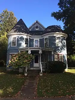 Fred Smart House |
November 15, 1988 (#88002215) |
Salina St. 43°38′35″N 76°04′08″W |
Lacona | |
| 77 | Standard Yarn Company Building | May 15, 2008 (#08000410) |
317 W. 1st St. 43°27′08″N 76°30′30″W |
Oswego | ||
| 78 | State Street Methodist Episcopal Church | 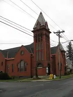 State Street Methodist Episcopal Church |
February 20, 2013 (#13000030) |
357 State St. 43°19′06″N 76°24′35″W |
Fulton | 1894 Romanesque Revival church represents city's prosperity at that time |
| 79 | Stillman Farmstead | Stillman Farmstead |
June 20, 1991 (#91000525) |
NY 104 between Co. Rt. 58 and US 11 43°27′33″N 76°09′47″W |
Mexico | |
| 80 | Stillwater Bridge | 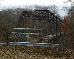 Stillwater Bridge |
November 7, 1997 (#97001385) |
Dam Rd. over Salmon R. 43°32′41″N 75°55′20″W |
Stillwater | |
| 81 | Sweet Memorial Building | 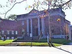 Sweet Memorial Building |
April 26, 1990 (#90000695) |
821 Main St. 43°13′45″N 76°17′58″W |
Phoenix | |
| 82 | Tanner Block | 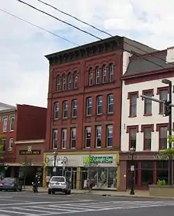 Tanner Block |
December 25, 2009 (#09001269) |
175-177 W. First St. 43°27′25″N 76°30′41″W |
Oswego | |
| 83 | Thayer Farmstead | 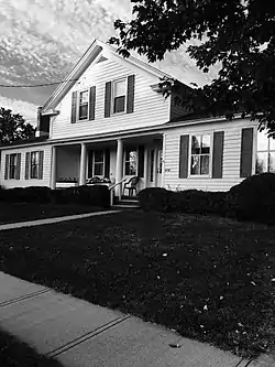 Thayer Farmstead |
November 14, 1991 (#91001631) |
5933 Church St. 43°27′11″N 76°13′35″W |
Mexico | |
| 84 | Trinity Church | 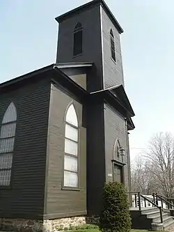 Trinity Church |
October 29, 1982 (#82001231) |
NY 49 43°14′52″N 76°00′29″W |
Constantia | |
| 85 | Newman Tuttle House | November 15, 1988 (#88002211) |
Harwood Dr. at Ridge Rd. 43°38′37″N 76°03′51″W |
Lacona | ||
| 86 | U.S. Customhouse | 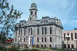 U.S. Customhouse |
November 21, 1976 (#76001262) |
W. Oneida St. between 1st and 2nd Sts. 43°27′17″N 76°30′40″W |
Oswego | |
| 87 | US Post Office-Fulton | 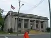 US Post Office-Fulton |
May 11, 1989 (#88002519) |
214 S. First St. 43°19′03″N 76°24′53″W |
Fulton | |
| 88 | David Van Buren House | June 9, 1988 (#88000726) |
Van Buren Dr., W end at the Oswego River 43°21′37″N 76°25′45″W |
Fulton | ||
| 89 | John Van Buren Tavern | November 3, 1988 (#88002377) |
NY 57 and Van Buren Dr. 43°21′35″N 76°25′45″W |
Fulton | ||
| 90 | Volkert Van Buren House | October 7, 1988 (#88001707) |
NY 57 and Distin Rd. 43°22′01″N 76°25′34″W |
Fulton | ||
| 91 | Walton and Willett Stone Store | May 24, 1976 (#76001263) |
1 Seneca St. 43°27′35″N 76°30′43″W |
Oswego | ||
| 92 | Washington Square Historic District | December 25, 2009 (#09001270) |
E. 4th St., E. Oneida St., E. 3rd St. 43°27′26″N 76°30′16″W |
Oswego | ||
| 93 | West Broadway Commercial Historic District | December 1, 2020 (#100005848) |
109-126 West Broadway 43°18′57″N 76°25′08″W |
Fulton | ||
| 94 | Asa and Caroline Wing House | 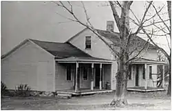 Asa and Caroline Wing House |
December 4, 2001 (#01001317) |
3392 NY 69 43°25′15″N 76°09′52″W |
Mexico | |
| 95 | Woodruff Block | April 20, 1995 (#95000473) |
17 W. Cayuga St. 43°27′28″N 76°30′46″W |
Oswego |
See also
| Wikimedia Commons has media related to National Register of Historic Places in Oswego County, New York. |
References
- The latitude and longitude information provided in this table was derived originally from the National Register Information System, which has been found to be fairly accurate for about 99% of listings. Some locations in this table may have been corrected to current GPS standards.
- "National Register of Historic Places: Weekly List Actions". National Park Service, United States Department of the Interior. Retrieved on January 29, 2021.
- Numbers represent an alphabetical ordering by significant words. Various colorings, defined here, differentiate National Historic Landmarks and historic districts from other NRHP buildings, structures, sites or objects.
- The eight-digit number below each date is the number assigned to each location in the National Register Information System database, which can be viewed by clicking the number.
| Topics | 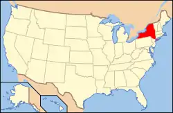 | |
|---|---|---|
| Lists by county |
| |
| Lists by city | ||
| Other lists | ||
| ||
This article is issued from Wikipedia. The text is licensed under Creative Commons - Attribution - Sharealike. Additional terms may apply for the media files.