National Register of Historic Places listings in Rockland County, New York
List of the National Register of Historic Places listings in Rockland County, New York
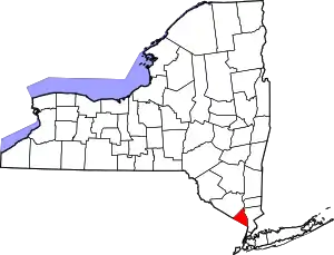
Location of Rockland County in New York
This is intended to be a complete list of properties and districts listed on the National Register of Historic Places in Rockland County, New York. The locations of National Register properties and districts (at least for all showing latitude and longitude coordinates below) may be seen in a map by clicking on "Map of all coordinates".[1] There are three properties and districts that are further designated U.S. National Historic Landmarks.
- This National Park Service list is complete through NPS recent listings posted January 29, 2021.[2]
| Albany (Albany) – Allegany – Bronx – Broome – Cattaraugus – Cayuga – Chautauqua – Chemung – Chenango – Clinton – Columbia – Cortland – Delaware – Dutchess (Poughkeepsie, Rhinebeck) – Erie (Buffalo) – Essex – Franklin – Fulton – Genesee – Greene – Hamilton – Herkimer – Jefferson – Kings – Lewis – Livingston – Madison – Monroe (Rochester) – Montgomery – Nassau – New York (Below 14th Street, 14th to 59th Streets, 59th to 110th Streets, Above 110th Street, Islands) – Niagara – Oneida – Onondaga – Ontario – Orange – Orleans – Oswego – Otsego – Putnam – Queens – Rensselaer – Richmond – Rockland – St. Lawrence – Saratoga – Schenectady – Schoharie – Schuyler – Seneca – Steuben – Suffolk – Sullivan – Tioga – Tompkins – Ulster – Warren – Washington – Wayne – Westchester (Northern, Southern, New Rochelle, Peekskill, Yonkers) – Wyoming – Yates |
Listings county-wide
| [3] | Name on the Register | Image | Date listed[4] | Location | City or town | Description |
|---|---|---|---|---|---|---|
| 1 | Maj. John Andre Monument | Maj. John Andre Monument |
November 8, 2006 (#06001001) |
42 Andre Hill 41°01′17″N 73°57′19″W |
Tappan | Site of Major John André's hanging and burial |
| 2 | Bear Mountain Bridge | 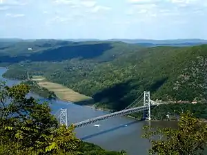 Bear Mountain Bridge |
November 23, 1982 (#82001266) |
NY 6/202 41°19′12″N 73°58′49″W |
Stony Point | First crossing of Hudson north of New York City; built 1924 by Harriman family and later turned over to state |
| 3 | Bear Mountain Inn | 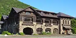 Bear Mountain Inn |
September 20, 2002 (#02001048) |
Seven Lakes Drive 41°18′47″N 73°59′25″W |
Bear Mountain | 1915 rustic lodge was among first improvements to Bear Mountain State Park |
| 4 | Big House | 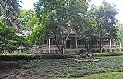 Big House |
July 12, 1990 (#90001008) |
US 9W near the junction with Closter Rd. 41°00′45″N 73°54′47″W |
Palisades | |
| 5 | Blauvelt House | 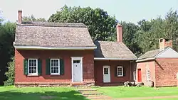 Blauvelt House |
March 28, 1985 (#85000659) |
20 Zukor Rd. 41°10′16″N 73°59′13″W |
New City | |
| 6 | Blauvelt–Cropsey Farm |  Blauvelt–Cropsey Farm |
January 31, 2017 (#100000614) |
230 S. Little Tor Rd. 41°07′57″N 74°00′03″W |
New City | 1790s sandstone farmhouse that incorporates Dutch and English building traditions; has remained a working family farm despite suburbanization of surrounding area |
| 7 | Brick Church Complex | 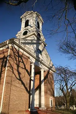 Brick Church Complex |
September 7, 1984 (#84002947) |
Brick Church Rd. and NY 306 41°08′25″N 74°03′55″W |
New Hempstead | |
| 8 | Brook Chapel |  Brook Chapel |
February 14, 2010 (#09001287) |
6th St. 41°07′29″N 74°10′35″W |
Hillburn | |
| 9 | Brookside | 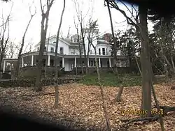 Brookside |
July 10, 2012 (#12000408) |
406 N. Broadway 41°06′20″N 73°55′05″W |
Upper Nyack | |
| 10 | Camp Hill School | 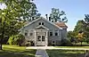 Camp Hill School |
August 8, 2019 (#100004244) |
100 Ladentown Road 41°10′58″N 74°03′18″W |
Pomona | Two-room schoolhouse built in 1923 remained in use until the 1960s; now Pomona's village hall |
| 11 | Christ Church |  Christ Church |
May 18, 2011 (#11000291) |
416 Valentine Ave. 41°01′48″N 73°55′34″W |
Sparkill | |
| 12 | Cliffside | 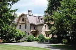 Cliffside |
July 12, 1990 (#90001012) |
Lawrence Ln. south of River Rd. 41°00′28″N 73°54′14″W |
Palisades | |
| 13 | Closter Road-Oak Tree Road Historic District | 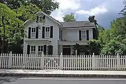 Closter Road-Oak Tree Road Historic District |
July 12, 1990 (#90001014) |
Roughly, north side of Closter Rd. and south side of Oak Tree Rd. approximately 0.5 miles (0.80 km) west of US 9W 41°00′43″N 73°55′03″W |
Palisades | |
| 14 | Abner Concklin House | 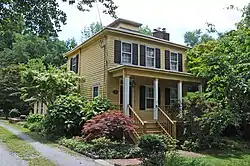 Abner Concklin House |
August 6, 1987 (#87001358) |
Closter Rd. 41°00′26″N 73°55′14″W |
Palisades | |
| 15 | Contempora House | 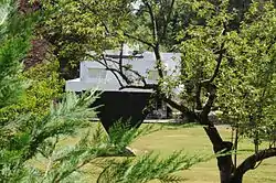 Contempora House |
April 29, 2009 (#09000260) |
88 S. Mountain Rd. 41°10′58″N 74°01′03″W |
New City | |
| 16 | De Wint House | 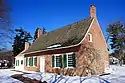 De Wint House |
October 15, 1966 (#66000568) |
Livingston Ave. and Oak Tree Rd. 41°01′11″N 73°56′47″W |
Tappan | Oldest house in county. Headquarters of George Washington: August 1780, September–October 1780, May 1783. Site of John André spy trial during American Revolutionary War. |
| 17 | John A. DeBaun Mill | 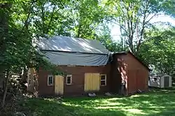 John A. DeBaun Mill |
September 2, 1993 (#93000852) |
NY 59, N side, opposite Highview Ave. 41°06′45″N 74°06′16″W |
Tallman | |
| 18 | Peter DePew House | 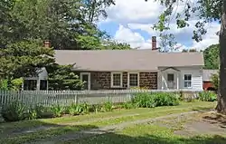 Peter DePew House |
July 3, 2008 (#08000596) |
101 Old Route 304 41°10′13″N 73°58′39″W |
New City | |
| 19 | Dederer Stone House-Stonehurst |  Dederer Stone House-Stonehurst |
December 31, 2002 (#02001650) |
82 Rockland Rd. 41°01′53″N 73°55′20″W |
Orangetown | |
| 20 | English Church and Schoolhouse | 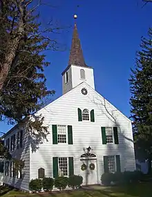 English Church and Schoolhouse |
November 23, 1977 (#77000980) |
484 New Hempstead Rd. 41°08′59″N 74°01′58″W |
New City | 1827 Federal-style church built for first English congregation established in New York west of Hudson a century earlier is second-oldest church in county. 1863 schoolhouse was in use as a public school building for over a century. |
| 21 | William Ferdon House | 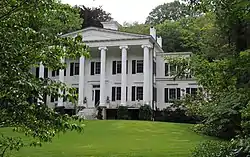 William Ferdon House |
May 18, 2011 (#11000292) |
270 Ferdon Ave. 41°02′06″N 73°55′08″W |
Piermont | |
| 22 | First Methodist Episcopal Church of Nyack |  First Methodist Episcopal Church of Nyack |
February 20, 1998 (#98000132) |
North Broadway, south of the junction of North Broadway and Birchwood Ave. 41°06′12″N 73°55′04″W |
Upper Nyack | |
| 23 | First Reformed Church | 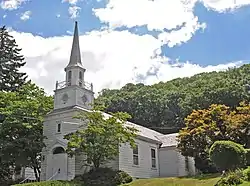 First Reformed Church |
November 9, 2015 (#15000777) |
361 Ferdon Ave. 41°02′12″N 73°55′11″W |
Piermont | Wren-Gibbs Colonial Revival Church, built 1946, is home to oldest congregation in Piermont |
| 24 | Fraser-Hoyer House | 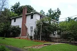 Fraser-Hoyer House |
April 22, 1976 (#76001270) |
Treason Hill off U.S. 9W 41°12′41″N 73°59′17″W |
West Haverstraw | |
| 25 | John Green House |  John Green House |
June 7, 2017 (#100000615) |
23 Main St. 41°05′26″N 73°54′58″W |
Nyack | 1819 stone house is believed to be the oldest in the village |
| 26 | Gurnee–Sherwood House |  Gurnee–Sherwood House |
July 19, 2011 (#11000451) |
29 Spook Rock Road 41°09′34″N 74°05′48″W |
Wesley Hills | |
| 27 | Haddock's Hall | 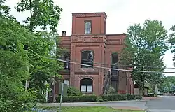 Haddock's Hall |
June 20, 1991 (#91000103) |
300 Ferdon Ave. 41°02′07″N 73°55′08″W |
Piermont | |
| 28 | Haring-Eberle House | 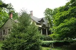 Haring-Eberle House |
July 12, 1990 (#90001010) |
US 9W north of Oak Tree Rd. 41°00′43″N 73°54′45″W |
Palisades | |
| 29 | The Homestead | 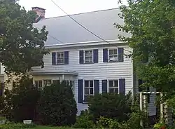 The Homestead |
November 10, 1983 (#83004154) |
143 Hudson Ave. 41°11′36″N 73°58′00″W |
Village of Haverstraw | Farmhouse built ca. 1800 is one of oldest buildings in Haverstraw; residence of former mayor and other officials |
| 30 | Houser-Conklin House |  Houser-Conklin House |
October 1, 2010 (#10000808) |
246 Route 306 41°08′05″N 74°04′00″W |
Monsey | |
| 31 | Edward Hopper Birthplace and Boyhood Home | 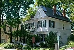 Edward Hopper Birthplace and Boyhood Home |
April 6, 2000 (#00000352) |
82 North Broadway 41°05′35″N 73°55′06″W |
Nyack | |
| 32 | Hopson-Swan Estate | 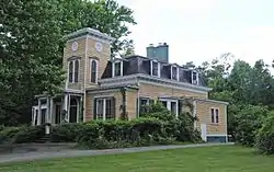 Hopson-Swan Estate |
November 23, 1992 (#92001562) |
US 9W east of Sparkill, Tallman Mountain State Park 41°01′37″N 73°54′59″W |
Sparkill | |
| 33 | Kings Daughters Public Library |  Kings Daughters Public Library |
August 9, 1991 (#91000950) |
Jct. of Main and Allison Sts. 41°11′47″N 73°57′39″W |
Village of Haverstraw | Recently renovated 1903 building was home to oldest chartered public library in county (now a branch) |
| 34 | Ladentown United Methodist Church | 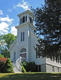 Ladentown United Methodist Church |
September 7, 2005 (#05000990) |
Ladentown Rd. 41°11′07″N 74°04′05″W |
Pomona | |
| 35 | Little House | 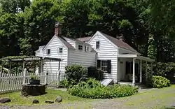 Little House |
July 12, 1990 (#90001009) |
US 9W north of Oak Tree Rd. 41°00′43″N 73°54′45″W |
Palisades | |
| 36 | M/V COMMANDER | 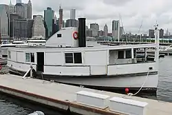 M/V COMMANDER |
September 27, 1984 (#84002951) |
Haverstraw Marina 41°13′52″N 73°58′32″W |
Village of Haverstraw | |
| 37 | Main School | .jpg.webp) Main School |
August 5, 2015 (#15000516) |
45 Mountain Ave. 41°07′30″N 74°10′11″W |
Hillburn | Early 20th century wooden school was site of New York's biggest school desegregation battle |
| 38 | Carson McCullers House |  Carson McCullers House |
July 14, 2006 (#06000562) |
131 S. Broadway 41°05′09″N 73°55′11″W |
South Nyack | |
| 39 | Robert W. and Mary F. McCready House |  Robert W. and Mary F. McCready House |
October 4, 2011 (#11000708) |
139 Orange Turnpike 41°09′51″N 74°11′34″W |
Sloatsburg | Eclectic 1889 Victorian home of Irish immigrant builder whose firm was instrumental in the development of Sloatsburg during that era |
| 40 | Mount Moor African-American Cemetery |  Mount Moor African-American Cemetery |
August 29, 1994 (#94001001) |
Dexter Rd., off NY 59A 41°05′47″N 73°57′33″W |
West Nyack | On the grounds of the Palisades Center mall. |
| 41 | Neiderhurst | 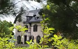 Neiderhurst |
July 12, 1990 (#90001011) |
Ludlow Ln. south of River Rd. 41°00′35″N 73°54′29″W |
Palisades | |
| 42 | North Main Street School |  North Main Street School |
February 28, 2008 (#08000105) |
185 N. Main St. 41°07′22″N 74°02′36″W |
Spring Valley | One of the earliest modern school buildings in the county, built in 1916 and expanded several times since. Now a satellite campus of Rockland Community College. |
| 43 | Old Sloatsburg Cemetery |  Old Sloatsburg Cemetery |
July 23, 1999 (#99000807) |
Richards Rd. 41°09′13″N 74°11′48″W |
Sloatsburg | Graves from late 18th to mid-20th centuries, including Sloat family members. Landscaping reflects different eras of cemetery design. |
| 44 | Onderdonk House |  Onderdonk House |
September 28, 2006 (#06000890) |
748 Piermont Ave. 41°02′51″N 73°55′09″W |
Piermont | |
| 45 | Palisades Interstate Park | 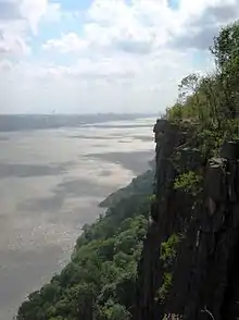 Palisades Interstate Park |
October 15, 1966 (#66000890) |
W bank of the Hudson River 40°57′19″N 73°55′54″W |
Fort Lee | Extends through several NY and NJ counties. |
| 46 | Henry M. Peck House | November 2, 2000 (#00001279) |
US 9W at Helen Hayes Hospital 41°12′44″N 73°59′18″W |
West Haverstraw | Destroyed by fire in 2002. | |
| 47 | Jacob P. Perry House |  Jacob P. Perry House |
July 3, 2003 (#03000594) |
15 Sickeletown Rd. 41°03′16″N 73°59′28″W |
Pearl River | House dating from turn of 19th century is one of the last built in pre-Revolutionary Dutch Colonial style. |
| 48 | Philadelphia Toboggan Company Carousel Number 15 | Philadelphia Toboggan Company Carousel Number 15 |
June 8, 2001 (#01000583) |
1000 Palisades Center 41°05′48″N 73°57′22″W |
West Nyack | Formerly located in the Palisades Center but was removed in the summer of 2009.[5] |
| 49 | Piermont Railroad Station | 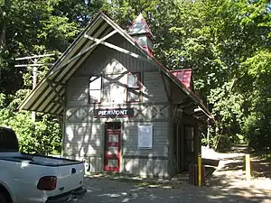 Piermont Railroad Station |
December 3, 2008 (#08001146) |
50 Ash Street 41°02′30″N 73°55′06″W |
Piermont | |
| 50 | Pig Knoll School |  Pig Knoll School |
July 8, 2019 (#100004183) |
584 NY 306 41°10′13″N 74°04′03″W |
Pomona | Rustic 1915 Arts and Crafts by Robb Wilder of Mead, McKim and White is today Pomona Cultural Center |
| 51 | Henry Varnum Poor House | 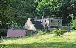 Henry Varnum Poor House |
December 11, 2007 (#07001258) |
S. Mountain Rd. 41°11′01″N 74°00′59″W |
New City | |
| 52 | Richard Pousette-Dart House and Studio | December 23, 2019 (#100004802) |
932 Haverstraw Road 41°09′54″N 74°05′41″W |
Suffern vicinity | 1916 carriage house was later home to influential abstract expressionist painter Pousette-Dart | |
| 53 | House at 352 Piermont Avenue |  House at 352 Piermont Avenue |
January 27, 2015 (#14001218) |
352 Piermont Ave. 41°02′13″N 73°55′11″W |
Piermont | Well-preserved 1780 stone house is one of few of its design in county |
| 54 | Rockland County Courthouse and Dutch Gardens | 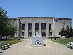 Rockland County Courthouse and Dutch Gardens |
January 3, 1991 (#90002104) |
Jct. of S. Main St. and New Hempstead Rd. 41°08′47″N 73°59′27″W |
New City | |
| 55 | Rockland Print Works |  Rockland Print Works |
October 23, 2013 (#13000362) |
55 W. Railroad Ave. 41°12′32″N 73°59′32″W |
Garnerville | Surviving factory complex from area's industrial past |
| 56 | Rockland Road Bridge | 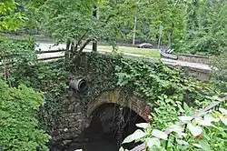 Rockland Road Bridge |
December 7, 2005 (#05001391) |
Rockland Rd., (bounded by Piermont and Ferdon Aves.) 41°02′06″N 73°55′10″W |
Piermont | |
| 57 | Rockland Road Bridge Historic District | 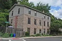 Rockland Road Bridge Historic District |
September 29, 2011 (#11000709) |
Ferdon Ave., Rockland Rd. & S. Piermont Ave. 41°02′06″N 73°55′10″W |
Piermont | |
| 58 | William H. Rose House | 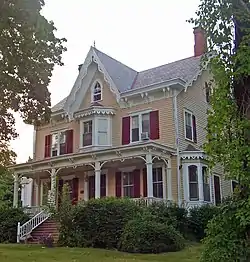 William H. Rose House |
April 15, 1999 (#99000459) |
110 Tomkin Ave. 41°14′00″N 73°59′04″W |
Stony Point | Picturesque house of local businessman built ca. 1862 moved from original nearby location |
| 59 | Ross-Hand Mansion |  Ross-Hand Mansion |
September 8, 1983 (#83001787) |
122 S. Franklin St. 41°05′12″N 73°55′23″W |
South Nyack | |
| 60 | St. Paul's United Methodist Church | 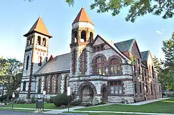 St. Paul's United Methodist Church |
March 12, 2001 (#01000251) |
S. Broadway and Division St. 41°05′13″N 73°55′22″W |
Nyack | |
| 61 | St. Paul's Episcopal Church |  St. Paul's Episcopal Church |
July 2, 2008 (#08000593) |
26 S. Madison Ave. 41°06′32″N 74°02′45″W |
Spring Valley | |
| 62 | Edward Salyer House |  Edward Salyer House |
September 4, 1986 (#86002178) |
241 S. Middletown Rd. 41°03′04″N 74°00′51″W |
Pearl River | Rare surviving Dutch Colonial frame house, built in 1765. Believed to be oldest house in Pearl River. |
| 63 | Michael Salyer Stone House |  Michael Salyer Stone House |
December 31, 2002 (#02001654) |
Blue Hill Rd. 41°03′07″N 73°59′16″W |
Orangetown | 1790 house has clapboard infill at gambrel roof's apex, much more common for Ulster County stone houses. May reflect Huguenot influence during construction. |
| 64 | Seaman–Knapp House |  Seaman–Knapp House |
May 24, 2012 (#12000311) |
35 Ladentown Rd. 41°11′12″N 74°03′33″W |
Pomona | |
| 65 | Seven Oaks Estate | 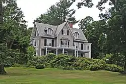 Seven Oaks Estate |
July 12, 1990 (#90001013) |
End of Ludlow Ln. 41°00′26″N 73°54′33″W |
Palisades | |
| 66 | Shadowcliff | 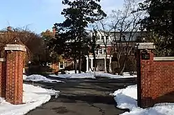 Shadowcliff |
April 7, 2014 (#14000131) |
521 N. Broadway 41°06′32″N 73°55′06″W |
Upper Nyack | |
| 67 | Sloat House |  Sloat House |
November 5, 1974 (#74001301) |
19 Orange Tpke. 41°09′02″N 74°11′38″W |
Sloatsburg | Original 1755 home of Sloat family, added onto in 1810s. Has bullet holes from accidental shooting of John Sloat |
| 68 | Sloat's Dam and Mill Pond |  Sloat's Dam and Mill Pond |
April 6, 2000 (#00000344) |
Off of Station Rd. 41°09′28″N 74°11′22″W |
Sloatsburg | Only surviving dam of three on the upper Ramapo River dates to 1792. Powered Jacob Sloat's mills; used until 1955 |
| 69 | Jacob Sloat House | 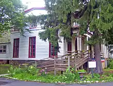 Jacob Sloat House |
December 22, 2006 (#06001144) |
15 Liberty Rock Rd. 41°09′19″N 74°11′43″W |
Sloatsburg | Also known as Harmony Hall. 1848 retirement home of local textile merchant who gave village its name illustrates transition from Greek Revival to Picturesque in American architecture. |
| 70 | Sparkill Creek Drawbridge | .jpg.webp) Sparkill Creek Drawbridge |
March 28, 1985 (#85000658) |
Bridge St. over Sparkill Creek 41°02′14″N 73°54′58″W |
Piermont | |
| 71 | H. R. Stevens House | 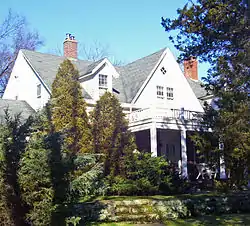 H. R. Stevens House |
January 14, 2005 (#04001480) |
234 Congers Rd. 41°09′02″N 73°58′24″W |
New City | 1775 house of locally quarried sandstone shows convergence of Dutch and English vernacular building traditions. Frame Federal style expansion done in 1820s. |
| 72 | Stony Point Battlefield | 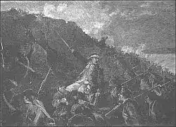 Stony Point Battlefield |
October 15, 1966 (#66000567) |
North of Stony Point on U.S. 9W and 202 41°14′32″N 73°58′25″W |
Stony Point | |
| 73 | Stony Point District School No. 4 | 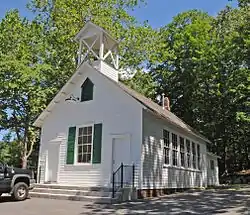 Stony Point District School No. 4 |
January 4, 2012 (#11001005) |
Central Dr. at Cedar Flats Rd. 41°14′16″N 74°01′17″W |
Stony Point | |
| 74 | Stony Point Lighthouse |  Stony Point Lighthouse |
May 29, 1979 (#79001626) |
Stony Point Battlefield 41°14′29″N 73°58′20″W |
Stony Point | |
| 75 | Tallman–Budke and Vanderbilt–Budke–Traphagen Houses |  Tallman–Budke and Vanderbilt–Budke–Traphagen Houses |
July 3, 2017 (#100001266) |
131 Germonds Road 41°06′59″N 73°59′12″W |
Clarkstown | 1790 sandstone house, believed to be one of the oldest of that material in the county, and 1820s wooden farmhouse on same property. |
| 76 | Tappan Historic District | 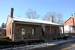 Tappan Historic District |
April 26, 1990 (#90000689) |
Roughly bounded by Main St./Kings Hwy., Andre Ave. and New York Central RR 41°01′18″N 73°56′58″W |
Tappan | |
| 77 | Tappan Zee Playhouse | 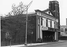 Tappan Zee Playhouse |
July 21, 1983 (#83001788) |
20 S. Broadway 41°05′24″N 73°55′09″W |
Nyack | Demolished 2004.Cinema Treasures |
| 78 | Terneur-Hutton House | 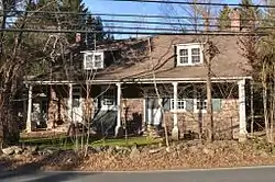 Terneur-Hutton House |
April 23, 1973 (#73001263) |
160 Sickelton Rd. 41°04′58″N 73°58′23″W |
West Nyack | |
| 79 | Torne Brook Farm |  Torne Brook Farm |
May 19, 1988 (#88000611) |
Torne Brook Rd. 41°08′25″N 74°09′48″W |
Ramapo | |
| 80 | Upper Nyack Firehouse | 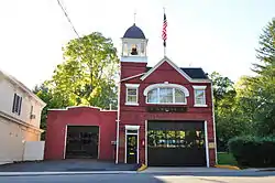 Upper Nyack Firehouse |
September 23, 1982 (#82004781) |
330 N. Broadway 41°06′06″N 73°55′04″W |
Upper Nyack | |
| 81 | US Post Office-Haverstraw | 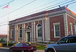 US Post Office-Haverstraw |
November 17, 1988 (#88002497) |
86 Main St. 41°11′46″N 73°57′39″W |
Village of Haverstraw | High level of ornament on 1934 building may be due to influence of native James Farley, then Postmaster General |
| 82 | US Post Office-Nyack | 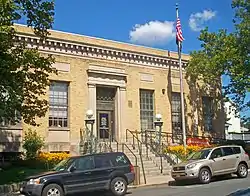 US Post Office-Nyack |
May 11, 1989 (#88002387) |
48 S. Broadway 41°05′19″N 73°55′11″W |
Nyack | Rare Classical Revival post office built after World War I |
| 83 | US Post Office-Pearl River | 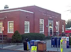 US Post Office-Pearl River |
November 17, 1988 (#88002399) |
35 S. Main St.[6] 41°03′29″N 74°01′20″W |
Pearl River | Unique 1935 post office with highly restrained Colonial Revival design showing a strong modernist influence. Officially renamed in 2005 for local Vietnam War MIA |
| 84 | US Post Office-Spring Valley | 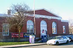 US Post Office-Spring Valley |
May 11, 1989 (#88002432) |
7 N. Madison Ave. 41°06′47″N 74°02′46″W |
Spring Valley | Colonial Revival design of 1936 post office, unique in state, emphasizes Greek Revival precedents of style |
| 85 | US Post Office-Suffern | 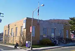 US Post Office-Suffern |
May 11, 1989 (#88002435) |
15 Chestnut St. 41°06′59″N 74°09′10″W |
Suffern | 1930s building combining elements of Streamline Moderne and Colonial Revival styles; inside features relief of Communication as a semi-nude woman shooting a flaming arrow. |
| 86 | The USCO Church | 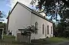 The USCO Church |
May 3, 2016 (#16000225) |
21 Church St. 41°12′24″N 73°59′42″W |
Garnerville | 19th-century wooden former Methodist church used by late-1960s art collective USCO |
| 87 | Van Houten's Landing Historic District | 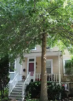 Van Houten's Landing Historic District |
August 20, 2004 (#04000877) |
North Broadway, School St., Ellen St., Castle Heights Ave., Van Houten St. 41°06′02″N 73°55′00″W |
Upper Nyack | |
| 88 | Washington Avenue Soldier's Monument and Triangle | 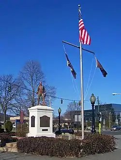 Washington Avenue Soldier's Monument and Triangle |
July 26, 2006 (#06000646) |
Washington Avenue Triangle (Jct. of Washington and Lafayette Aves.) 41°06′53″N 74°09′01″W |
Suffern | Memorial to local World War I dead on site where Washington and Lafayette camped features small cannon left over from Revolution |
| 89 | Washington Spring Road-Woods Road Historic District | 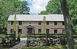 Washington Spring Road-Woods Road Historic District |
July 12, 1990 (#90001015) |
Roughly, area along Washington Spring Rd. from Highland Ave. to the Hudson River and north approximately 0.5 miles (0.80 km) along Woods Rd. 41°00′42″N 73°54′26″W |
Palisades | |
| 90 | Former Wayside Chapel | 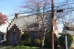 Former Wayside Chapel |
April 6, 2000 (#00000346) |
24 River Rd. 41°04′24″N 73°55′14″W |
Grand View-on-Hudson |
Former listing
| [3] | Name on the Register | Image | Date listed | Date removed | Location | City or town | Summary |
|---|---|---|---|---|---|---|---|
| 1 | Henry Garner Mansion | August 14, 1973 (#73001262) | Unknown | 18 Railroad Ave. |
West Haverstraw |
See also
| Wikimedia Commons has media related to National Register of Historic Places in Rockland County, New York. |
References
- The latitude and longitude information provided in this table was derived originally from the National Register Information System, which has been found to be fairly accurate for about 99% of listings. Some locations in this table may have been corrected to current GPS standards.
- "National Register of Historic Places: Weekly List Actions". National Park Service, United States Department of the Interior. Retrieved on January 29, 2021.
- Numbers represent an alphabetical ordering by significant words. Various colorings, defined here, differentiate National Historic Landmarks and historic districts from other NRHP buildings, structures, sites or objects.
- The eight-digit number below each date is the number assigned to each location in the National Register Information System database, which can be viewed by clicking the number.
- PALISADES CENTER REPLACES HISTORIC CAROUSEL - New York Post - August 27, 2009
- Address based on USPS website. Accessed March 2, 2016.
| Topics | 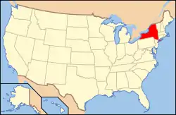 | |
|---|---|---|
| Lists by county |
| |
| Lists by city | ||
| Other lists | ||
| ||
This article is issued from Wikipedia. The text is licensed under Creative Commons - Attribution - Sharealike. Additional terms may apply for the media files.