National Register of Historic Places listings in Riverhead (town), New York
This list is intended to provide a comprehensive listing of entries in the National Register of Historic Places in the Town of Riverhead, New York. The locations of National Register properties for which the latitude and longitude coordinates are included below, may be seen in a Google map.[1]
Listings
| [2] | Name on the Register | Image | Date listed[3] | Location | City or town | Description |
|---|---|---|---|---|---|---|
| 1 | Hallock-Bilunas Farmstead | Hallock-Bilunas Farmstead |
April 18, 2003 (#03000251) |
733 Herricks Lane 40°58′42″N 72°35′30″W |
Jamesport | |
| 2 | Downs House and Farm | May 31, 2016 (#16000308) |
5793 Sound Ave. 40°58′46″N 72°36′01″W |
Northville | 1873 Italianate farmhouse at center of farm with varying agricultural products over the years | |
| 3 | Jedediah Hawkins House |  Jedediah Hawkins House |
June 13, 2008 (#08000514) |
400 South Jamesport Avenue 40°56′50″N 72°34′46″W |
Jamesport | |
| 4 | Hallock Homestead | 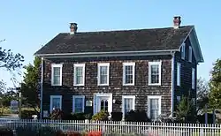 Hallock Homestead |
June 7, 1984 (#84002992) |
163 Sound Avenue 40°59′02″N 72°35′12″W |
Northville | |
| 5 | Jamesport Meeting House |  Jamesport Meeting House |
February 20, 2009 (#09000039) |
1590 Main Road 40°57′00″N 72°34′52″W |
Jamesport | |
| 6 | Riverhead Main Street Historic District | 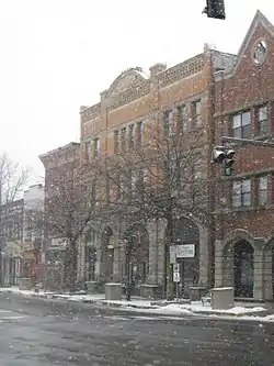 Riverhead Main Street Historic District |
August 14, 2012 (#12000512) |
Roughly E. & W. Main Sts., Griffing, Roanoke, Maple, & Peconic Aves. 40°55′03″N 72°39′39″W |
Riverhead | |
| 7 | Second and Ostrander Historic District | August 18, 2017 (#100001491) |
Various 40°55′09″N 72°39′39″W |
Riverhead | ||
| 8 | Suffolk County Historical Society Building | 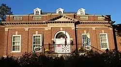 Suffolk County Historical Society Building |
July 29, 1994 (#94000786) |
300 West Main Street 40°55′05″N 72°40′05″W |
Riverhead | |
| 9 | Daniel and Henry P. Tuthill Farm | 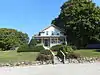 Daniel and Henry P. Tuthill Farm |
August 5, 2015 (#15000518) |
1146 Main Road 40°56′55″N 72°36′02″W |
Jamesport | Mid-19th century family potato farm with surviving buildings |
| 10 | Tuthill-Lapham House | 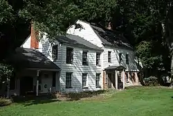 Tuthill-Lapham House |
March 13, 2009 (#09000136) |
324 Sound Road, at the corner of Sunset Boulevard 40°57′53″N 72°51′08″W |
Wading River | |
| 11 | US Post Office-Riverhead | 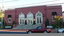 US Post Office-Riverhead |
May 11, 1989 (#88002424) |
23 West Second Street 40°55′06″N 72°39′50″W |
Riverhead | part of the US Post Offices in New York State, 1858-1943, Thematic Resource (TR) |
| 12 | Vail-Leavitt Music Hall |  Vail-Leavitt Music Hall |
August 25, 1983 (#83001809) |
Peconic Avenue 40°54′59″N 72°39′45″W |
Riverhead | |
| 13 | Wading River Radio Station | 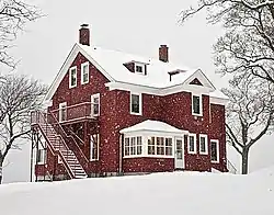 Wading River Radio Station |
May 4, 2018 (#100002389) |
408 North Side Road 40°58′05″N 72°50′26″W |
Wading River | Benson House at Camp DeWolfe; used for covert FBI counterintelligence operation against Germany during World War II |
| 14 | Benjamin King Woodhull House | June 13, 2008 (#08000515) |
126 Sound Road 40°57′31″N 72°51′02″W |
Wading River |
See also
| Wikimedia Commons has media related to National Register of Historic Places in Suffolk County, New York. |
References
- The latitude and longitude information provided is primarily from the National Register Information System, and has been found to be fairly accurate for about 99% of listings. For 1%, the location info may be way off. We seek to correct the coordinate information wherever it is found to be erroneous. Please leave a note in the Discussion page for this article if you believe any specific location is incorrect.
- Numbers represent an alphabetical ordering by significant words. Various colorings, defined here, differentiate National Historic Landmarks and historic districts from other NRHP buildings, structures, sites or objects.
- The eight-digit number below each date is the number assigned to each location in the National Register Information System database, which can be viewed by clicking the number.
External links
- NRHP applications for New York State sites (Note, interface works best with Microsoft Internet Explorer browser; hit "Results" after searching, to actually see the results).
| Topics |  | |
|---|---|---|
| Lists by county |
| |
| Lists by city | ||
| Other lists | ||
| ||
This article is issued from Wikipedia. The text is licensed under Creative Commons - Attribution - Sharealike. Additional terms may apply for the media files.