National Register of Historic Places listings in Shelter Island (town), New York
This is a List of the National Register of Historic Places listings on Shelter, New York
This list is intended to provide a comprehensive listing of entries in the National Register of Historic Places in the Town of Shelter Island, New York. The locations of National Register properties for which the latitude and longitude coordinates are included below, may be seen in a Google map.[1]
Listings
| [2] | Name on the Register | Image | Date listed[3] | Location | City or town | Description |
|---|---|---|---|---|---|---|
| 1 | Camp Quinipet | 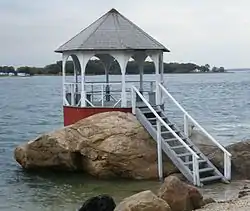 Camp Quinipet |
October 5, 2005 (#05001133) |
78 Shore Road 41°04′15″N 72°22′56″W |
Shelter Island Heights | |
| 2 | James Havens Homestead |  James Havens Homestead |
April 10, 1986 (#86000701) |
NY 114 41°03′49″N 72°19′53″W |
Shelter Island | |
| 3 | Manhanset Chapel | 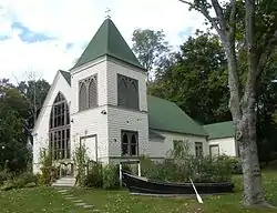 Manhanset Chapel |
August 29, 1997 (#97000979) |
24 North Ferry Road 41°04′05″N 72°20′10″W |
Shelter Island | |
| 4 | Shelter Island Country Club | 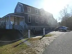 Shelter Island Country Club |
February 25, 2009 (#09000058) |
26 Sunnyside Avenue 41°04′39″N 72°21′33″W |
Shelter Island | |
| 5 | Shelter Island Heights Historic District | 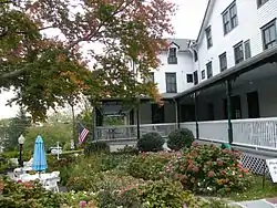 Shelter Island Heights Historic District |
May 7, 1993 (#93000335) |
Roughly bounded by St. Johns Street, Tower Hill Road, Sunnyside Avenue, Meadow Place, Chase Creek, and Dering Harbor 41°05′04″N 72°21′26″W |
Shelter Island Heights | |
| 6 | Shelter Island Windmill | 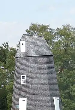 Shelter Island Windmill |
December 27, 1978 (#78001917) |
N of Manwaring Road 41°04′33″N 72°20′08″W |
Shelter Island | |
| 7 | Smith–Ransome Japanese Bridge | February 2, 2018 (#100002080) |
24 Merkel Lane 41°03′02″N 72°19′09″W |
Shelter Island | 1905 decorative reinforced concrete bridge designed by Ernest Ransome for Francis Marion Smith's estate makes rare use for Ransome of Japanese-influenced design popular at that time.[4] | |
| 8 | Smith-Taylor Cabin | 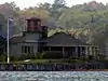 Smith-Taylor Cabin |
September 28, 2007 (#07001016) |
Taylor's Island 41°04′17″N 72°17′55″W |
Shelter Island | On Taylor Island |
| 9 | Sylvester Manor |  Sylvester Manor |
April 28, 2015 (#15000178) |
80 N. Ferry Rd. 41°04′49″N 72°20′28″W |
Shelter Island | 1652 plantation homestead now used as educational farm |
| 10 | Union Chapel | 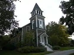 Union Chapel |
November 23, 1984 (#84000296) |
The Grove 41°05′02″N 72°21′32″W |
Shelter Island Heights |
See also
| Wikimedia Commons has media related to National Register of Historic Places in Suffolk County, New York. |
References
- The latitude and longitude information provided is primarily from the National Register Information System, and has been found to be fairly accurate for about 99% of listings. For 1%, the location info may be way off. We seek to correct the coordinate information wherever it is found to be erroneous. Please leave a note in the Discussion page for this article if you believe any specific location is incorrect.
- Numbers represent an alphabetical ordering by significant words. Various colorings, defined here, differentiate National Historic Landmarks and historic districts from other NRHP buildings, structures, sites or objects.
- The eight-digit number below each date is the number assigned to each location in the National Register Information System database, which can be viewed by clicking the number.
- Japanese Bridge; Shelter Island, New York (Bridgehunter.com)
External links
- NRHP applications for New York State sites (Note, interface works best with Microsoft Internet Explorer browser; hit "Results" after searching, to actually see the results).
| Topics |  | |
|---|---|---|
| Lists by county |
| |
| Lists by city | ||
| Other lists | ||
| ||
This article is issued from Wikipedia. The text is licensed under Creative Commons - Attribution - Sharealike. Additional terms may apply for the media files.