National Register of Historic Places listings in Smithtown (town), New York
This list is intended to provide a comprehensive listing of entries in the National Register of Historic Places in Town of Smithtown, New York. The locations of National Register properties for which the latitude and longitude coordinates are included below, may be seen in a Google map.[1]
Listings
| [2] | Name on the Register | Image | Date listed[3] | Location | City or town | Description |
|---|---|---|---|---|---|---|
| 1 | Beachbend | August 9, 1993 (#93000698) |
Smith Lane 40°54′10″N 73°11′03″W |
Nissequogue | ||
| 2 | Blydenburgh Park Historic District | 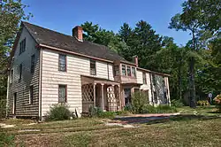 Blydenburgh Park Historic District |
August 11, 1983 (#83001807) |
Blydenburgh County Park 40°50′36″N 73°13′34″W |
Smithtown | |
| 3 | Box Hill Estate | December 4, 1973 (#73001276) |
Northwest of St. James on Moriches Road 40°53′22″N 73°10′36″W |
St. James | ||
| 4 | By-the-Harbor | August 9, 1993 (#93000699) |
Moriches Road 40°53′30″N 73°10′51″W |
Nissequogue | ||
| 5 | East Farm | 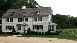 East Farm |
August 9, 1993 (#93000700) |
Harbor Road, North side, at Shep Jones Lane 40°54′48″N 73°09′17″W |
Head of the Harbor | |
| 6 | First Presbyterian Church | 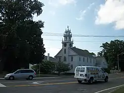 First Presbyterian Church |
December 23, 1977 (#77000983) |
175 East Main Street 40°51′24″N 73°11′18″W |
Branch | |
| 7 | Fort Salonga | May 21, 1982 (#82003406) |
Address Restricted |
Fort Salonga | ||
| 8 | Halliock Inn |  Halliock Inn |
August 7, 1974 (#74001310) |
263 East Main Street 40°51′20″N 73°10′50″W |
Branch | |
| 9 | Harbor House | 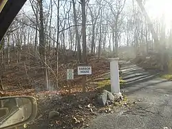 Harbor House |
August 9, 1993 (#93000701) |
Spring Hollow Road 40°53′48″N 73°10′44″W |
Nissequogue | |
| 10 | Hauppauge Methodist Episcopal Church | _and_Cemetery%252C_Hauppauge%252C_NY%252C_National_Register_of_Historic_Places.jpg.webp) Hauppauge Methodist Episcopal Church |
August 27, 2020 (#100005484) |
473 Town Line Road 40°49′31″N 73°12′20″W |
Hauppauge | |
| 11 | Land of Clover |  Land of Clover |
August 9, 1993 (#93000702) |
Long Beach Road, South side 40°54′48″N 73°11′12″W |
Nissequogue | The former Lathrop Brown Estate, now occupied by a private boarding school called The Knox School.[4][5] |
| 12 | The Mallows | August 9, 1993 (#93000703) |
Emmet Way 40°54′59″N 73°09′07″W |
Head of the Harbor | ||
| 13 | Mills Pond District | %252C_Saint_James%252C_Suffolk_County%252C_NY_HABS_NY%252C52-STJAM.V%252C1-6.tif.jpg.webp) Mills Pond District |
August 1, 1973 (#73001277) |
East of St. James on NY 25A 40°54′02″N 73°08′58″W |
St. James | |
| 14 | James W. and Anne Smith Phyfe Estate | August 9, 1993 (#93000704) |
87 Stillwater Road 40°54′34″N 73°11′04″W |
Nissequogue | ||
| 15 | Rassapeague | 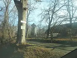 Rassapeague |
August 9, 1993 (#93000705) |
Long Beach Road, South side 40°54′58″N 73°10′55″W |
Nissequogue | |
| 16 | William J. Ryan Estate | August 9, 1993 (#93000706) |
Moriches Road 40°54′07″N 73°11′20″W |
Nissequogue | ||
| 17 | Saint James District |  Saint James District |
July 20, 1973 (#73001275) |
On NY 25A 40°53′02″N 73°09′46″W |
Saint James | |
| 18 | Shore Cottage | August 9, 1993 (#93000707) |
Harbor Road, East side 40°53′39″N 73°10′23″W |
Head of the Harbor | ||
| 19 | Obadiah Smith House | .jpg.webp) Obadiah Smith House |
December 6, 1996 (#96001422) |
853 Saint Johnland Road 40°53′38″N 73°13′47″W |
Kings Park | |
| 20 | Thatch Meadow Farm | February 20, 2020 (#93000711) |
Harbor Rd., west side, opposite Bacon Rd. 40°54′31″N 73°09′32″W |
Head of the Harbor | Last remaining portion of old estate, built on 18th century farm. | |
| 21 | Village of Branch Historic District | September 11, 1986 (#86002514) |
Along north side of Middle Country Road 40°51′56″N 73°10′59″W |
Branch | ||
| 22 | Frederick and Annie Wagner Residence and St. Patrick's Roman Catholic Church | 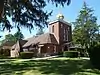 Frederick and Annie Wagner Residence and St. Patrick's Roman Catholic Church |
August 8, 2019 (#100004240) |
37 Juniper Avenue & 38 Mayflower Avenue 40°51′17″N 73°12′08″W |
Smithtown | 1912 Gustav Stickley house for early American motorsports promoter, and adjacent Tudor Revival Catholic church that served Smithtown's Irish American community from same era |
| 23 | Kate Annette Wetherill Estate |  Kate Annette Wetherill Estate |
August 9, 1993 (#93000708) |
Harbor Hill Road, South side 40°53′32″N 73°10′11″W |
Head of the Harbor | |
| 24 | Woodcrest | August 9, 1993 (#93000709) |
Moriches Road 40°54′00″N 73°10′59″W |
Nissequogue | ||
| 25 | Wyandanch Club Historic District |  Wyandanch Club Historic District |
August 3, 1990 (#90001143) |
Jericho Turnpike, southwest of its junction with Meadow Road 40°51′03″N 73°13′40″W |
Smithtown |
See also
| Wikimedia Commons has media related to National Register of Historic Places in Suffolk County, New York. |
References
- The latitude and longitude information provided is primarily from the National Register Information System, and has been found to be fairly accurate for about 99% of listings. For 1%, the location info may be way off. We seek to correct the coordinate information wherever it is found to be erroneous. Please leave a note in the Discussion page for this article if you believe any specific location is incorrect.
- Numbers represent an alphabetical ordering by significant words. Various colorings, defined here, differentiate National Historic Landmarks and historic districts from other NRHP buildings, structures, sites or objects.
- The eight-digit number below each date is the number assigned to each location in the National Register Information System database, which can be viewed by clicking the number.
- Land of Clover (Old Long Island)
- The Knox School (Official Site)
| Topics |  | |
|---|---|---|
| Lists by county |
| |
| Lists by city | ||
| Other lists | ||
| ||
This article is issued from Wikipedia. The text is licensed under Creative Commons - Attribution - Sharealike. Additional terms may apply for the media files.