National Register of Historic Places listings in central Puerto Rico
This portion of National Register of Historic Places listings in Puerto Rico is along the central mountain region, from Las Marías and Maricao in the central-west to Juncos in the central-east, including the slopes of the Cordillera.
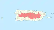
National Register entries listed below are found in the highlighted 24 municipalities of Puerto Rico.
See also:
- National Register of Historic Places listings in eastern Puerto Rico
- National Register of Historic Places listings in southern Puerto Rico
- National Register of Historic Places listings in northern Puerto Rico
- National Register of Historic Places listings in western Puerto Rico
- National Register of Historic Places listings in San Juan, Puerto Rico
Names of places given are as appear in the National Register, reflecting name as given in NRHP application at the date of listing. Note, the National Register name system does not accommodate Spanish á, ñ and other letters.
- This National Park Service list is complete through NPS recent listings posted January 29, 2021.[1]
Adjuntas
| [2] | Name on the Register | Image | Date listed[3] | Location | Barrio | Description |
|---|---|---|---|---|---|---|
| 1 | Las Cabañas Bridge | 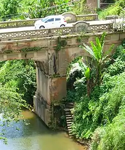 Las Cabañas Bridge |
July 19, 1995 (#95000838) |
Highway 135, km 82.4, spanning Río de las Vacas 18°10′47″N 66°44′11″W |
Capáez and Juan González[lower-alpha 1] | This 1919 bridge, intended to provide access to a key coffee-producing region, was financed by nearby plantations through public subscription. Designer Rafael Nones and builder Félix Benítez Rexach used a unique combination of steel and concrete technologies to produce a girder design unlike any other on the island.[4] |
| 2 | Quinta Vendrell | February 9, 2006 (#06000028) |
Junction of Highway 143 and Highway 123 18°08′50″N 66°41′24″W |
Portugués | ||
| 3 | Washington Irving Graded School[9] | 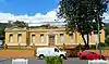 Washington Irving Graded School[11] |
May 26, 2015 (#15000274) |
Junction of Rodulfo González and Martínez de Andino Streets 18°09′42″N 66°43′20″W[12]) |
Adjuntas Pueblo |
Aguas Buenas
| [2] | Name on the Register | Image | Date listed[3] | Location | Barrio | Description |
|---|---|---|---|---|---|---|
| 1 | Parque de Bombas Maximiliano Merced | 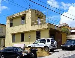 Parque de Bombas Maximiliano Merced |
November 14, 2012 (#12000934) |
42 Muñoz Rivera Street 18°15′24″N 66°06′18″W |
Aguas Buenas Pueblo |
Aibonito
| [2] | Name on the Register | Image | Date listed[3] | Location | Barrio | Description |
|---|---|---|---|---|---|---|
| 1 | Carretera Central | May 2, 2019 (#100003686) |
Highway 14 from Cayey boundary to Coamo boundary[lower-alpha 2] 18°08′27″N 66°15′34″W |
Robles, Plata, Caonillas, Aibonito Pueblo, Llanos, Pasto, Asomante, and Algarrobo | Built by the Spanish administration during 1846–1886 to connect San Juan with Ponce, this was one of the first modern roadways in Puerto Rico and was regarded as one of the finest roads in the Americas for years after its completion. The listed portion of the road, from Caguas to Juana Díaz, includes the exceptionally challenging engineering through the Cordillera Central, 11 major bridges, 14 maintenance workers' houses,[lower-alpha 3] and numerous other roadway structures.[13][14] | |
| 2 | Church San José of Aibonito | .jpg.webp) Church San José of Aibonito |
December 10, 1984 (#84000451) |
Emeterio Betances Street 18°08′20″N 66°15′59″W |
Aibonito Pueblo | |
| 3 | Villa Julita | December 19, 1996 (#86003491) |
401 San José Avenue 18°08′30″N 66°15′27″W |
Aibonito Pueblo |
Barranquitas
| [2] | Name on the Register | Image | Date listed[3] | Location | Barrio | Description |
|---|---|---|---|---|---|---|
| 1 | Casa Natal de Luis Muñoz Rivera |  Casa Natal de Luis Muñoz Rivera |
September 4, 1984 (#84003139) |
Muñoz Rivera and Manuel Torres Streets 18°11′11″N 66°18′25″W |
Barranquitas Pueblo | Birthplace of Luis Muñoz Rivera, also known as Museo-Biblioteca Muñoz Rivera |
| 2 | El Cortijo | September 11, 2018 (#100002934) |
Highway 162, km 18.5 18°10′57″N 66°18′35″W |
Barranquitas Pueblo | 1939 house designed by architect Rafael Carmoega Morales | |
| 3 | Palo Hincado Site | September 2, 1999 (#99001021) |
Address restricted[15] |
Address restricted[15] | Ball Courts/Plaza Sites of Puerto Rico and the U.S. Virgin Islands MPS |
Caguas
| [2] | Name on the Register | Image | Date listed[3] | Location | Barrio | Description |
|---|---|---|---|---|---|---|
| 1 | Aguayo Aldea Vocational High School | 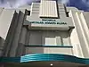 Aguayo Aldea Vocational High School |
September 4, 1987 (#87001311) |
Junction of San Juan and Principal Streets 18°13′56″N 66°01′49″W |
Caguas Pueblo | An Art Deco school from 1939 |
| 2 | Alcaldía de Caguas | 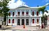 Alcaldía de Caguas |
March 22, 1989 (#88001307) |
42 Muñoz Rivera Street 18°14′05″N 66°02′09″W |
Caguas Pueblo | Built in 1856 |
| 3 | Carretera Central | May 2, 2019 (#100003686) |
Highway 1 from km 40 to Cidra boundary[lower-alpha 2] 18°11′10″N 66°04′32″W |
Turabo, Borinquen, and Beatriz | Built by the Spanish administration during 1846–1886 to connect San Juan with Ponce, this was one of the first modern roadways in Puerto Rico and was regarded as one of the finest roads in the Americas for years after its completion. The listed portion of the road, from Caguas to Juana Díaz, includes the exceptionally challenging engineering through the Cordillera Central, 11 major bridges, 14 maintenance workers' houses,[lower-alpha 3] and numerous other roadway structures.[13][16] | |
| 4 | Gautier Benítez High School | 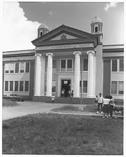 Gautier Benítez High School |
June 15, 1988 (#88000657) |
Gautier Benítez Avenue and Cristóbal Colón Boulevard 18°13′40″N 66°02′10″W |
Caguas Pueblo | Built in 1924 |
| 5 | Logia Unión y Amparo No. 44 | 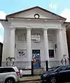 Logia Unión y Amparo No. 44 |
June 15, 1988 (#88000661) |
39 Acosta Street 18°14′02″N 66°02′01″W |
Caguas Pueblo | Designed by Antonin Nechodoma |
| 6 | Primera Iglesia Bautista de Caguas | 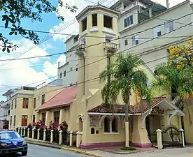 Primera Iglesia Bautista de Caguas |
September 24, 2008 (#08000949) |
Corner of Ruiz Belvis and Intendente Ramírez Streets 18°14′05″N 66°02′01″W |
Caguas Pueblo | Built in 1909 |
| 7 | Puente No. 6 | %252C_Barrio_Rio_Ca%C3%B1as%252C_Caguas%252C_Puerto_Rico_(1899).jpg.webp) Puente No. 6 |
May 28, 2009 (#09000361) |
Highway 798, km 1.0 18°17′43″N 66°03′26″W |
Río Cañas | Also known as Puente la Concepción |
Cayey
| [2] | Name on the Register | Image | Date listed[3] | Location | Barrio | Description |
|---|---|---|---|---|---|---|
| 1 | Arenas Bridge | 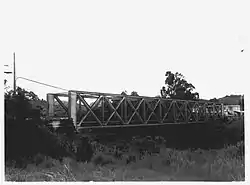 Arenas Bridge |
July 19, 1995 (#95000843) |
Highway 735, km 1.3, spanning Río de la Plata 18°08′03″N 66°08′17″W |
Monte Llano and Arenas[lower-alpha 4] | A metal truss bridge from 1894, also known as "Puente Río La Plata" |
| 2 | Carretera #4 | October 30, 2020 (#100005741) |
PR-15, from km. 0 in Guayama to km. 25.7 in Cayey 18°03′01″N 66°08′07″W |
Guayama to Cayey | ||
| 3 | Carretera Central | May 2, 2019 (#100003686) |
Highway 1 from Cidra boundary to km 55.4; Highway 14 from km 74 to Aibonito boundary; Highway 735[lower-alpha 2] 18°07′26″N 66°10′53″W |
Beatriz, Vegas, Monte Llano, Cayey Pueblo, Rincón, Toíta, and Matón Abajo | Built by the Spanish administration during 1846–1886 to connect San Juan with Ponce, this was one of the first modern roadways in Puerto Rico and was regarded as one of the finest roads in the Americas for years after its completion. The listed portion of the road, from Caguas to Juana Díaz, includes the exceptionally challenging engineering through the Cordillera Central, 11 major bridges, 14 maintenance workers' houses,[lower-alpha 3] and numerous other roadway structures.[13][16] | |
| 4 | Church Nuestra Señora de la Asunción of Cayey | 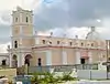 Church Nuestra Señora de la Asunción of Cayey |
December 10, 1984 (#84000454) |
Muñoz Rivera Street, Town Plaza 18°06′46″N 66°09′57″W |
Cayey Pueblo | Spanish Colonial style church from 1815, designed by José Canovas |
| 5 | La Liendre Bridge |  La Liendre Bridge |
July 19, 1995 (#95000844) |
Highway 735, km 0.7, spanning Quebrada Beatriz 18°08′05″N 66°07′54″W |
Vegas and Arenas[lower-alpha 5] | An iron lattice lateral girder bridge from 1877 |
| 6 | Río Matón Bridge | July 19, 1995 (#95000841) |
Highway 14, km 63.2, spanning Río Matón 18°08′23″N 66°12′39″W |
Matón Abajo | A lateral solid web girder bridge from 1886 | |
| 7 | Juana Rodríguez Morales House | April 6, 2005 (#05000257) |
7 Nuñez Romeu Street 18°06′48″N 66°09′58″W |
Cayey Pueblo | Spanish Creole townhouse from 1850 |
Ciales
| [2] | Name on the Register | Image | Date listed[3] | Location | Barrio | Description |
|---|---|---|---|---|---|---|
| 1 | Manatí Bridge at Mata de Plátano |  Manatí Bridge at Mata de Plátano |
July 19, 1995 (#95000847) |
Highway 6685, km 9.7, spanning Río Grande de Manatí 18°21′32″N 66°28′45″W |
Hato Viejo |
Cidra
| [2] | Name on the Register | Image | Date listed[3] | Location | Barrio | Description |
|---|---|---|---|---|---|---|
| 1 | Arenas Bridge | Arenas Bridge |
July 19, 1995 (#95000843) |
Highway 735, km 1.3, spanning Río de la Plata 18°08′04″N 66°08′17″W |
Arenas and Monte Llano[lower-alpha 4] | A metal truss bridge from 1894, also known as "Puente Río La Plata" |
| 2 | La Bolero | August 28, 2012 (#12000584) |
Highway 173, km 0.5 18°10′50″N 66°09′41″W |
Ceiba | Early Prototypes for Manufacturing Plants in Puerto Rico, 1948-1958 Multiple Property Submission (MPS) | |
| 3 | Carretera Central | May 2, 2019 (#100003686) |
Highway 1 from Caguas boundary to Cayey boundary; Highway 735[lower-alpha 2] 18°09′07″N 66°06′18″W |
Beatriz and Arenas | Built by the Spanish administration during 1846–1886 to connect San Juan with Ponce, this was one of the first modern roadways in Puerto Rico and was regarded as one of the finest roads in the Americas for years after its completion. The listed portion of the road, from Caguas to Juana Díaz, includes the exceptionally challenging engineering through the Cordillera Central, 11 major bridges, 14 maintenance workers' houses,[lower-alpha 3] and numerous other roadway structures.[13][16] | |
| 4 | La Liendre Bridge | 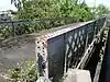 La Liendre Bridge |
July 19, 1995 (#95000844) |
Highway 735, km 0.7, spanning Quebrada Beatriz 18°08′05″N 66°07′54″W |
Arenas and Vegas[lower-alpha 5] | An iron lattice lateral girder bridge from 1877 |
Coamo
| [2] | Name on the Register | Image | Date listed[3] | Location | Barrio | Description |
|---|---|---|---|---|---|---|
| 1 | Carretera Central | 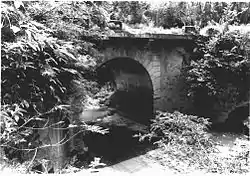 Carretera Central |
May 2, 2019 (#100003686) |
Highway 14 from Aibonito boundary to Juana Díaz boundary[lower-alpha 2] 18°04′39″N 66°21′43″W |
Cuyón, Palmarejo, Coamo Pueblo, San Ildefonso, and Los Llanos | Built by the Spanish administration during 1846–1886 to connect San Juan with Ponce, this was one of the first modern roadways in Puerto Rico and was regarded as one of the finest roads in the Americas for years after its completion. The listed portion of the road, from Caguas to Juana Díaz, includes the exceptionally challenging engineering through the Cordillera Central, 11 major bridges, 14 maintenance workers' houses,[lower-alpha 3] and numerous other roadway structures.[13][16] |
| 2 | Casa Blanca | 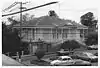 Casa Blanca |
April 28, 1992 (#92000379) |
17 José I. Quintón Street 18°04′48″N 66°21′22″W |
Coamo Pueblo | Spanish Creole architecture from 1865 |
| 3 | Church San Blas de Illescas of Coamo |  Church San Blas de Illescas of Coamo |
December 10, 1984 (#84000463) |
Mario Braschi Street 18°04′51″N 66°21′22″W |
Coamo Pueblo | Latin American Baroque architecture of a church from 1661 |
| 4 | General Méndez Vigo Bridge | General Méndez Vigo Bridge |
July 19, 1995 (#95000839) |
Highway 14, km 30.4, spanning Las Minas River 18°03′50″N 66°22′27″W |
San Ildefonso | Brick barrel vault bridge from 1898, by US Corps of Engineers, also known as Puente Rio las Minas |
| 5 | Hermitage Church of Nuestra Señora de Valvanera of Coamo | March 31, 1986 (#86000700) |
Junction of José I. Quintón and Carrión Maduro Streets 18°04′46″N 66°21′33″W |
Coamo Pueblo | Church from 1685 | |
| 6 | Padre Iñigo Bridge | July 19, 1995 (#95000840) |
Highway 14, km 34.2, spanning Río Coamo 18°04′53″N 66°21′15″W |
Coamo Pueblo and Palmarejo | Lattice girder bridge from 1879 | |
| 7 | Picó Pomar Residence | July 12, 1988 (#88000961) |
Junction of José I. Quintón and Mario Braschi Streets 18°04′49″N 66°21′25″W |
Coamo Pueblo | Spanish Neoclassical building from 1840, also known as Coamo Historic Museum | |
| 8 | Puente de las Calabazas | 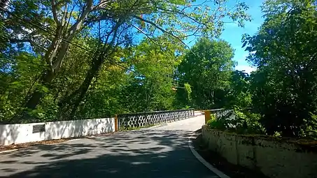 Puente de las Calabazas |
February 17, 2009 (#09000042) |
Highway 14, km 39.3, spanning Río Cuyón 18°05′17″N 66°18′48″W |
Cuyón | Lattice girder bridge from 1882 |
Comerío
| [2] | Name on the Register | Image | Date listed[3] | Location | Barrio | Description |
|---|---|---|---|---|---|---|
| 1 | Cueva La Mora | March 10, 1983 (#83002292) |
Address restricted[15] |
Address restricted[15] | ||
| 2 | Río Hondo Bridge | 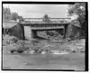 Río Hondo Bridge |
July 19, 1995 (#95000842) |
Highway 156, km 26.9, spanning Río Hondo 18°12′31″N 66°14′35″W |
Río Hondo | Originally installed in 1881 over the Río de la Plata, this span survived an 1899 hurricane, then was moved and re-installed on new abutments in 1908. As of 1995, it was the oldest bridge truss in Puerto Rico, employing a double pony truss design and unique open-web transverse joists.[17] It was removed in 2001.[18] |
Corozal
| [2] | Name on the Register | Image | Date listed[3] | Location | Barrio | Description |
|---|---|---|---|---|---|---|
| 1 | Mavilla Bridge | 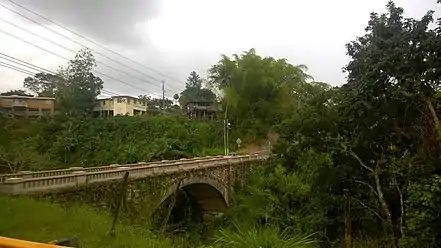 Mavilla Bridge |
July 19, 1995 (#95000848) |
Highway 159, km 17.7, spanning Río Mavilla 18°21′07″N 66°17′50″W |
Palmarejo and Abras |
Gurabo
| [2] | Name on the Register | Image | Date listed[3] | Location | Barrio | Description |
|---|---|---|---|---|---|---|
| 1 | Church San José of Gurabo | September 18, 1984 (#84003142) |
Santiago and Eugenio Sánches López Streets 18°15′18″N 65°58′21″W |
Gurabo Pueblo | Church from 1821 |
Jayuya
| [2] | Name on the Register | Image | Date listed[3] | Location | Barrio | Description |
|---|---|---|---|---|---|---|
| 1 | La Piedra Escrita | 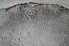 La Piedra Escrita |
January 15, 2003 (#02001720) |
Highway 144, km 8[19] 18°13′02″N 66°34′23″W |
Coabey | Prehistoric rock art site |
Juncos
| [2] | Name on the Register | Image | Date listed[3] | Location | Barrio | Description |
|---|---|---|---|---|---|---|
| 1 | José Miguel Gallardo School | 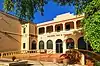 José Miguel Gallardo School |
November 14, 2012 (#12000937) |
Junction of Paseo Escuté and Algarín Street 18°13′41″N 65°55′27″W |
Juncos Pueblo |
Lares
| [2] | Name on the Register | Image | Date listed[3] | Location | Barrio | Description |
|---|---|---|---|---|---|---|
| 1 | Callejones Site | September 2, 1999 (#99001022) |
Address restricted[15] |
Address restricted[15] | An archaeological site | |
| 2 | Hacienda Los Torres | 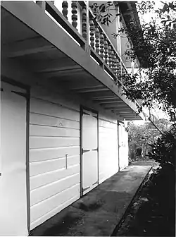 Hacienda Los Torres |
September 28, 2006 (#06000896) |
Junction of Highways 111 and 129 18°17′48″N 66°52′16″W |
Lares | Mission/Spanish Revival building from 1846 |
Las Marías
| [2] | Name on the Register | Image | Date listed[3] | Location | Barrio | Description |
|---|---|---|---|---|---|---|
| 1 | Eugenio María de Hostos School | 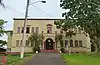 Eugenio María de Hostos School |
December 19, 2012 (#12001077) |
Matías Brugman Avenue 18°15′00″N 66°59′23″W |
Las Marías Pueblo |
Maricao
| [2] | Name on the Register | Image | Date listed[3] | Location | Barrio | Description |
|---|---|---|---|---|---|---|
| 1 | Church San Juan Bautista of Maricao | 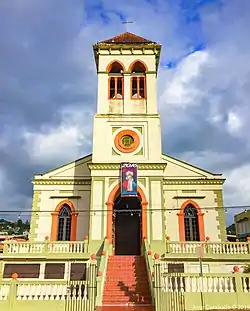 Church San Juan Bautista of Maricao |
September 18, 1984 (#84003125) |
Baldorioty Street, Town Plaza 18°10′51″N 66°58′46″W |
Maricao Pueblo | Gothic church built in 1890 |
| 2 | Del Treinta Bridge | July 19, 1995 (#95000846) |
Highway 128, km 32.7 18°10′00″N 66°51′48″W |
Indiera Alta | A rolled steel beam bridge from 1924, designed by Enrique Ortega | |
| 3 | Vivero de Peces de Maricao | 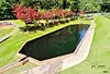 Vivero de Peces de Maricao |
February 21, 2017 (#100000667) |
Highway 410, km 1.7 18°10′14″N 66°59′14″W |
Maricao Afuera |
Morovis
| [2] | Name on the Register | Image | Date listed[3] | Location | Barrio | Description |
|---|---|---|---|---|---|---|
| 1 | José Fontán School | 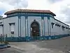 José Fontán School |
August 28, 2012 (#12000582) |
Junction of Del Carmen Street and Principal Street final 18°19′34″N 66°24′32″W |
Morovis Pueblo | part of the Early Twentieth Century Schools in Puerto Rico Thematic Resource (TR) |
Naranjito
| [2] | Name on the Register | Image | Date listed[3] | Location | Barrio | Description |
|---|---|---|---|---|---|---|
| 1 | Escuela Guillermo Estéves | December 19, 2012 (#12001078) |
Junction of Georgetti and Achiote Streets 18°18′05″N 66°14′55″W |
Naranjito Pueblo | ||
| 2 | Plata Bridge | 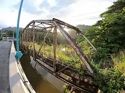 Plata Bridge |
July 19, 1995 (#95000849) |
Highway 167, km 0.9 18°18′14″N 66°12′40″W |
Nuevo and Dajaos[lower-alpha 6] | A Parker truss bridge |
Orocovis
| [2] | Name on the Register | Image | Date listed[3] | Location | Barrio | Description |
|---|---|---|---|---|---|---|
| 1 | Cueva La Espiral | September 20, 2011 (#11000673) |
Address restricted[15] |
Bauta Abajo[20] | Prehistoric Rock Art of Puerto Rico MPS |
San Lorenzo
| [2] | Name on the Register | Image | Date listed[3] | Location | Barrio | Description |
|---|---|---|---|---|---|---|
| 1 | Nuestra Señora de las Mercedes de San Miguel de Hato Grande | 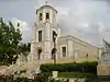 Nuestra Señora de las Mercedes de San Miguel de Hato Grande |
December 8, 1983 (#83004194) |
Colón Street, at Town Plaza 18°11′25″N 65°57′39″W |
San Lorenzo Pueblo | Also known as Las Mercedes, this Classical Revival style building was built in 1737 |
| 2 | Residencia Machín–Ramos | May 5, 1989 (#88001180) |
Eugenio Sánchez López Street 18°11′27″N 65°57′40″W |
San Lorenzo Pueblo | Spanish Colonial building from 1883 |
Trujillo Alto
| [2] | Name on the Register | Image | Date listed[3] | Location | Barrio | Description |
|---|---|---|---|---|---|---|
| 1 | Puente de Trujillo Alto | 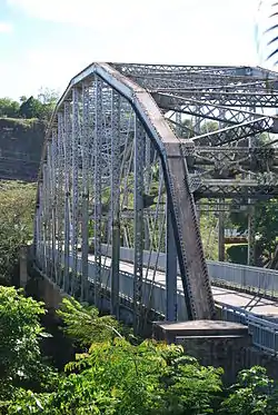 Puente de Trujillo Alto |
January 28, 2010 (#09001289) |
Highway 181, km 5.6 18°21′27″N 66°00′13″W |
Cuevas and Dos Bocas | Steel platform bridge over the Río Grande de Loíza; built in 1939 |
Utuado
| [2] | Name on the Register | Image | Date listed[3] | Location | Barrio | Description |
|---|---|---|---|---|---|---|
| 1 | Bateyes de Viví | June 21, 2007 (#07000584) |
Address restricted[15] |
Viví Arriba[21] | Ball Court/Plaza Sites of Puerto Rico and the U.S. Virgin Islands MPS | |
| 2 | Blanco Bridge | 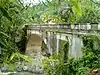 Blanco Bridge |
July 19, 1995 (#95000837) |
Highway 10, km 48.1, spanning the Pellejas River 18°13′48″N 66°43′02″W |
Arenas | Historic Bridges of Puerto Rico MPS |
| 3 | Caguana Ceremonial Ball Courts Site | 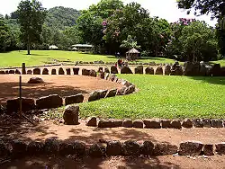 Caguana Ceremonial Ball Courts Site |
December 17, 1992 (#92001671) |
Highway 111, km 12.3 18°17′42″N 66°46′52″W |
Caguana | |
| 4 | Church San Miguel Arcángel of Utuado | 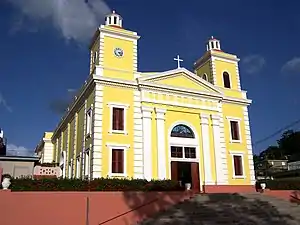 Church San Miguel Arcángel of Utuado |
December 10, 1984 (#84000447) |
Dr. Barbosa Street, Town Plaza 18°15′55″N 66°41′58″W |
Utuado Pueblo | Historic Churches of Puerto Rico TR |
Villalba
| [2] | Name on the Register | Image | Date listed[3] | Location | Barrio | Description |
|---|---|---|---|---|---|---|
| 1 | Walter McK. Jones School |  Walter McK. Jones School |
January 29, 2013 (#12001249) |
28 Luis Muñoz Rivera Street 18°07′47″N 66°29′31″W |
Villalba Pueblo |
See also
Notes
- Several prose sources place the Las Cabañas Bridge in Barrios Capáez and Garzas,[4][5][6] while other, map-based sources show it to be in Barrios Capáez and Juan González.[7][8]
- The listed portion of the Carretera Central extends into Caguas, Cidra, Cayey, Aibonito, Coamo, and Juana Díaz. The roadway route in San Juan and Ponce, as well as a portion in Caguas, was excluded from the National Register listing.
- Spanish: casillas de caminero.
- The Arenas Bridge spans the boundary between Cayey (Barrio Monte Llano) and Cidra (Barrio Arenas) municipalities.
- The La Liendre Bridge spans the boundary between Cayey (Barrio Vegas) and Cidra (Barrio Arenas) municipalities.
- The Plata Bridge spans the boundary between Naranjito (Barrio Nuevo) and Bayamón (Barrio Dajaos) municipalities.
References
- "National Register of Historic Places: Weekly List Actions". National Park Service, United States Department of the Interior. Retrieved on January 29, 2021.
- Numbers represent an alphabetical ordering by significant words. Various colorings, defined here, differentiate National Historic Landmarks and historic districts from other NRHP buildings, structures, sites or objects.
- The eight-digit number below each date is the number assigned to each location in the National Register Information System database, which can be viewed by clicking the number.
- Pumarada O'Neill, Luis (July 31, 1994), National Register of Historic Places Registration Form: Las Cabañas Bridge (PDF), retrieved February 22, 2016.
- Departamento de Transportación y Obras Públicas (n.d.), Nuestros Puentes Históricos: Puentes de Otros Tipos [Our Historic Bridges: Bridges of Other Types] (in Spanish), archived from the original on April 27, 2010, retrieved February 24, 2016CS1 maint: unfit URL (link).
- Oficina Estatal de Conservación Histórica (April 1, 2014), Puente de Las Cabañas (PDF) (summary sheet), retrieved February 24, 2016.
- Oficina Estatal de Conservación Histórica (n.d.), Puerto Rico: Registro Nacional de Lugares Históricos [Puerto Rico: National Register of Historic Places] (online GIS), retrieved February 24, 2016.
- Junta de Planificación (March 2009), Limites legales: Barrios [Legal boundaries: Barrios] (KML), retrieved February 24, 2016.
- https://www.nps.gov/subjects/nationalregister/upload/weekly-list-2015-national-register-of-historic-places.pdf
- https://www.nps.gov/subjects/nationalregister/upload/weekly-list-2015-national-register-of-historic-places.pdf
- https://www.nps.gov/subjects/nationalregister/upload/weekly-list-2015-national-register-of-historic-places.pdf
- https://www.nps.gov/subjects/nationalregister/upload/weekly-list-2015-national-register-of-historic-places.pdf
- Llanes Santos, Juan (March 5, 2019), National Register of Historic Places Registration Form: Carretera Central.
- "NRHP Nomination Form Carretera Central". Retrieved Aug 1, 2020.
- Federal and state laws and practices restrict general public access to information regarding the specific location of this resource. In some cases, this is to protect archaeological sites from vandalism, while in other cases it is restricted at the request of the owner. See: Knoerl, John; Miller, Diane; Shrimpton, Rebecca H. (1990), Guidelines for Restricting Information about Historic and Prehistoric Resources, National Register Bulletin, National Park Service, U.S. Department of the Interior, OCLC 20706997.
- Documento de inclusión de la Carretera Central en el RNLH (2019). Geo-Isla. 2020. Accessed 1 August 2020.
- Pumarada O'Neill, Luis (July 31, 1994), National Register of Historic Places Registration Form: Río Hondo Bridge (PDF), retrieved December 21, 2015.
- "Puente Río Hondo", Bridgehunter.com, archived from the original on September 5, 2015, retrieved December 21, 2015.
- "Discover Petroglyphs on Piedra Escrita in Jayuya", Puerto Rico Day Trips, March 1, 2015, archived from the original on September 7, 2015, retrieved January 24, 2016.
- Bonini Lamadrid, Miguel A. (May 16, 2011), National Register of Historic Places Registration Form: Cueva La Espiral (redacted PDF), retrieved December 23, 2015.
- Oliver, José R.; Rivera Fontán, Juan (September 30, 2006), National Register of Historic Places Registration Form: Bateyes de Viví (redacted PDF), retrieved December 23, 2015.
External links
This article is issued from Wikipedia. The text is licensed under Creative Commons - Attribution - Sharealike. Additional terms may apply for the media files.