National Register of Historic Places listings in northern Puerto Rico
This portion of National Register of Historic Places listings in Puerto Rico is along the north coast, north plains, and north slopes of the Cordillera, from Isabela to Guaynabo.
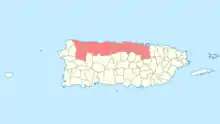
National Register entries listed below are found in the highlighted 17 municipalities of Puerto Rico.
Names of places given are as appear in the National Register, reflecting name as given in NRHP application at the date of listing. Note, the National Register name system does not accommodate Spanish á, ñ and other letters.
- This National Park Service list is complete through NPS recent listings posted January 29, 2021.[1]
Arecibo
| [2] | Name on the Register | Image | Date listed[3] | Location | Barrio | Description |
|---|---|---|---|---|---|---|
| 1 | Calle Gonzalo Marín No. 61 | 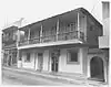 Calle Gonzalo Marín No. 61 |
October 19, 1986 (#88000645) |
61 Gonzalo Marín Street 18°28′19″N 66°42′53″W |
Arecibo Pueblo | |
| 2 | Cambalache Bridge | 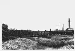 Cambalache Bridge |
July 19, 1995 (#95000831) |
Spanning Río Grande de Arecibo, west of Puerto Rico Highway 2 18°27′12″N 66°42′08″W |
Cambalache and Tanamá | |
| 3 | Casa Alcaldía de Arecibo | 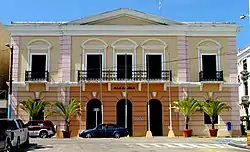 Casa Alcaldía de Arecibo |
September 29, 1986 (#86002762) |
José de Diego Avenue 18°28′21″N 66°42′56″W |
Arecibo Pueblo | A city hall, in Classical Revival style |
| 4 | Casa Córdova | 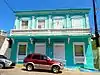 Casa Córdova |
November 17, 1986 (#86003185) |
14 Gonzalo Marín Street 18°28′21″N 66°42′49″W |
Arecibo Pueblo | |
| 5 | Casa de la Diosa Mita | 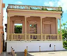 Casa de la Diosa Mita |
September 9, 1988 (#88000966) |
251 Fernández Juncos Street 18°28′17″N 66°43′09″W |
Arecibo Pueblo | A Beaux Arts house |
| 6 | Casa Ulanga | 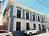 Casa Ulanga |
July 26, 1982 (#82003822) |
7 Gonzalo Marín Street 18°28′21″N 66°42′46″W |
Arecibo Pueblo | Used as a bank, store, city hall of Arecibo, hospital, jail, tribunal, and Cultural Center. |
| 7 | Corregimiento Plaza Theater |  Corregimiento Plaza Theater |
January 6, 1986 (#86000041) |
Llaguerry and Toribio Pagán Streets 18°28′22″N 66°42′55″W |
Arecibo Pueblo | |
| 8 | Edificio Oliver | 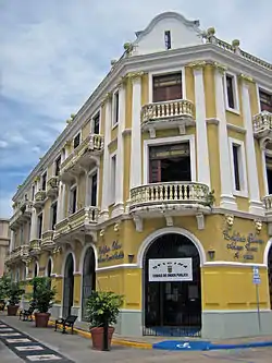 Edificio Oliver |
October 1, 1986 (#86002764) |
64 José de Diego Avenue 18°28′21″N 66°42′55″W |
Arecibo Pueblo | |
| 9 | Faro de Arecibo | 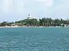 Faro de Arecibo |
November 23, 1977 (#77001546) |
Punta Morillos, Highway 655 18°28′55″N 66°41′55″W |
Arecibo Pueblo | Lighthouse built in 1898; Lighthouse System of Puerto Rico TR |
| 10 | Federico Degetau Consolidated Rural School | May 26, 2020 (#100005236) |
Carretera #662 Km. 68 Coordinates missing |
Arecibo vicinity | ||
| 11 | Gonzalo Marín 101 | 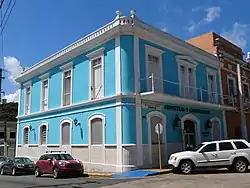 Gonzalo Marín 101 |
November 19, 1986 (#86003183) |
101 Gonzalo Marín Street 18°28′18″N 66°42′56″W |
Arecibo Pueblo | |
| 12 | National Astronomy and Ionosphere Center | .jpg.webp) National Astronomy and Ionosphere Center |
September 23, 2008 (#07000525) |
Highway 625, San Rafael Sector 18°20′45″N 66°45′10″W |
Esperanza | |
| 13 | Palacio del Marqués de las Claras | 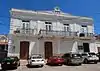 Palacio del Marqués de las Claras |
July 12, 1988 (#88000964) |
58 Gonzalo Marín Street 18°28′20″N 66°42′53″W |
Arecibo Pueblo | |
| 14 | Paseo Víctor Rojas | 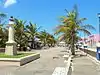 Paseo Víctor Rojas |
November 19, 1986 (#86003188) |
Gonzalo Marín Street at José de Diego Avenue 18°28′22″N 66°42′42″W |
Arecibo Pueblo |
Barceloneta
| [2] | Name on the Register | Image | Date listed[3] | Location | Barrio | Description |
|---|---|---|---|---|---|---|
| 1 | Rafael Balseiro Maceira School | 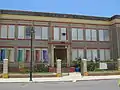 Rafael Balseiro Maceira School |
August 28, 2012 (#12000583) |
1 Georgetti Street 18°27′09″N 66°32′20″W |
Barceloneta Pueblo | part of the Early Twentieth Century Schools in Puerto Rico Thematic Resource (TR) |
Bayamón
| [2] | Name on the Register | Image | Date listed[3] | Location | Barrio | Description |
|---|---|---|---|---|---|---|
| 1 | Casa Dr. Agustín Stahl Stamm | 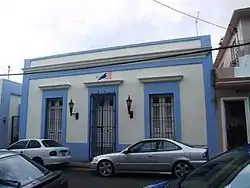 Casa Dr. Agustín Stahl Stamm |
February 4, 2011 (#10001216) |
14 José Martí St. 18°23′56″N 66°09′19″W |
Bayamón Pueblo | This 1840s house was the residence and laboratory of internationally recognized scientist Agustín Stahl (1842–1917)[lower-alpha 1] from 1865 until his death. Despite a modest physician's income, Stahl published important works in zoology, botany, medicine, agriculture, ethnology, demography, and history, and led public health campaigns across Puerto Rico.[4] |
| 2 | Casa Natal Dr. José Celso Barbosa | 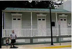 Casa Natal Dr. José Celso Barbosa |
August 24, 1984 (#84003156) |
16 Barbosa St. 18°23′57″N 66°09′16″W |
Bayamón Pueblo | House from 1850, associated with José Celso Barbosa |
| 3 | Church Santa Cruz of Bayamón | 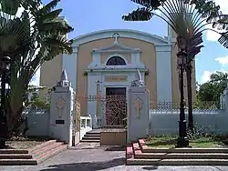 Church Santa Cruz of Bayamón |
September 18, 1984 (#84003162) |
Plaza de Hostos 18°23′56″N 66°09′21″W |
Bayamón Pueblo | Church from 1772 |
| 4 | Farmacia Serra | May 4, 1989 (#88000685) |
11 Degetau St. 18°23′57″N 66°09′20″W |
Bayamón Pueblo | ||
| 5 | Marqués de la Serna Bridge |  Marqués de la Serna Bridge |
July 19, 1995 (#95000850) |
Highway 890, km 24.1 18°24′10″N 66°09′21″W |
Juan Sánchez and Bayamón Pueblo | A rolled iron segmented arch bridge |
| 6 | Plata Bridge | 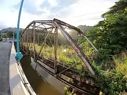 Plata Bridge |
July 19, 1995 (#95000849) |
Highway 167, km 0.9 18°18′14″N 66°12′41″W |
Dajaos and Nuevo[lower-alpha 2] | Bridge consisting of two Parker truss spans |
| 7 | Puerto Rico National Cemetery | 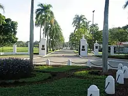 Puerto Rico National Cemetery |
September 26, 1983 (#83002298) |
Highway 168 18°24′44″N 66°10′00″W |
Hato Tejas | The only U.S. national cemetery outside of mainland U.S., established 1948 |
Camuy
| [2] | Name on the Register | Image | Date listed[3] | Location | Barrio | Description |
|---|---|---|---|---|---|---|
| 1 | Antiguo Casino Camuyano | 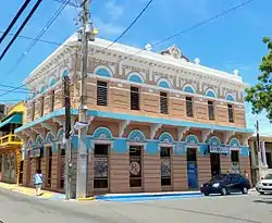 Antiguo Casino Camuyano |
January 26, 1984 (#84003123) |
Estrella and Muñoz Rivera Streets 18°29′03″N 66°50′42″W |
Camuy Pueblo | |
| 2 | Ernesto Memorial Chapel | .jpg.webp) Ernesto Memorial Chapel |
July 8, 2010 (#10000453) |
Intersection of Highway 486 and Highway 488 18°25′59″N 66°51′16″W |
Abra Honda | |
| 3 | Hacienda La Sabana | 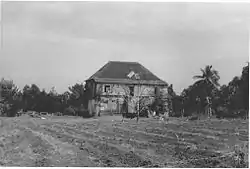 Hacienda La Sabana |
February 14, 1985 (#85000295) |
Highway 119, km 9.9 18°27′15″N 66°53′03″W |
Camuy Arriba |
Cataño
| [2] | Name on the Register | Image | Date listed[3] | Location | Barrio | Description |
|---|---|---|---|---|---|---|
| 1 | Bacardí Distillery | 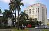 Bacardí Distillery |
August 6, 2010 (#10000524) |
Highway 165, km 2.6, intersection Highway 888, Bay View Industrial Park 18°27′31″N 66°08′29″W |
Palmas | |
| 2 | Sanctuary of Blessed Martín de Porres | 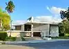 Sanctuary of Blessed Martín de Porres |
January 11, 2017 (#100000503) |
Comercio Street and Oeste Cementerio Street 18°26′37″N 66°07′59″W |
Palmas |
Dorado
| [2] | Name on the Register | Image | Date listed[3] | Location | Barrio | Description |
|---|---|---|---|---|---|---|
| 1 | SS Antonio López Shipwreck Site and Remains | 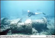 SS Antonio López Shipwreck Site and Remains |
February 9, 1994 (#93001593) |
Angelina Reef, off Mameyal Beach 18°28′48″N 66°13′50″W |
Mameyal | Sunken steel propeller steam liner, a U.S. National Historic Landmark |
| 2 | Casa del Rey | 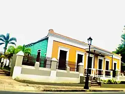 Casa del Rey |
May 19, 1989 (#89000408) |
292 Méndez Vigo Street 18°27′32″N 66°15′38″W |
Dorado Pueblo | Built from 1823 |
| 3 | Hacienda de Carlos Vassallo | 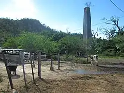 Hacienda de Carlos Vassallo |
March 22, 1989 (#88001848) |
Highway 693, km 0 18°24′37″N 66°15′45″W |
Maguayo | chimney of the sugar-processing mill built in 1861 |
| 4 | Jacinto Lopez Martinez Grammar School | 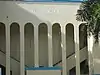 Jacinto Lopez Martinez Grammar School |
October 11, 1988 (#88001846) |
Norte and San Quintín Streets 18°27′36″N 66°15′43″W |
Dorado Pueblo | Mission/Spanish Revival school from 1923, designed by Pedro Adolfo de Castro |
| 5 | Residencia Don Andrés Hernández | 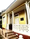 Residencia Don Andrés Hernández |
May 22, 1989 (#89000428) |
196 Norte Street 18°27′35″N 66°15′42″W |
Dorado Pueblo | Built in 1880 |
| 6 | Residencia Doña Antonia Ramírez | October 11, 1988 (#88001847) |
Highway 693, km 7 18°25′43″N 66°15′54″W |
Maguayo | Italianate building from 1921, designed by Camilo Munoz |
Florida
| [2] | Name on the Register | Image | Date listed[3] | Location | Barrio | Description |
|---|---|---|---|---|---|---|
| 1 | De Luxe Florida | 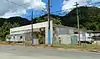 De Luxe Florida |
November 14, 2012 (#12000935) |
Highway 642, km 11.1 18°21′52″N 66°33′38″W |
Florida Adentro |
Guaynabo
| [2] | Name on the Register | Image | Date listed[3] | Location | Barrio | Description |
|---|---|---|---|---|---|---|
| 1 | Caparra | 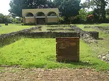 Caparra |
February 28, 1984 (#84003155) |
Highway 2, km 6.2 18°24′19″N 66°06′50″W |
Pueblo Viejo | Site of original, 1508 Spanish settlement in Puerto Rico |
| 2 | Iglesia Parroquial de San Pedro Martir de Guaynabo[lower-alpha 3] | 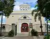 Iglesia Parroquial de San Pedro Martir de Guaynabo |
September 8, 1976 (#76002250) |
Plaza de Recreo 18°21′28″N 66°06′42″W |
Guaynabo Pueblo | [6] |
| 3 | Oficina de Telégrafo y Teléfono | 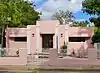 Oficina de Telégrafo y Teléfono |
July 3, 2012 (#12000396) |
1729 José E. Carazo St. 18°21′32″N 66°06′38″W |
Guaynabo Pueblo |
Hatillo
| [2] | Name on the Register | Image | Date listed[3] | Location | Barrio | Description |
|---|---|---|---|---|---|---|
| 1 | Church Nuestra Señora del Carmen of Hatillo | .jpg.webp) Church Nuestra Señora del Carmen of Hatillo |
December 10, 1984 (#84000443) |
Luis M. Lacomba Street 18°29′12″N 66°49′31″W |
Hatillo Pueblo |
Isabela
| [2] | Name on the Register | Image | Date listed[3] | Location | Barrio | Description |
|---|---|---|---|---|---|---|
| 1 | Hermitage of San Antonio de Padua de la Tuna |  Hermitage of San Antonio de Padua de la Tuna |
December 2, 1983 (#83004193) |
Ermita Street, La Tuna sector, Highway 2, km 106.1[8] 18°28′43″N 66°57′48″W |
Coto |
Manatí
| [2] | Name on the Register | Image | Date listed[3] | Location | Barrio | Description |
|---|---|---|---|---|---|---|
| 1 | Brunet–Calaf Residence |  Brunet–Calaf Residence |
September 1, 1988 (#88001306) |
Corner of Quiñones and Patriota Pozo Streets 18°25′39″N 66°29′34″W |
Manatí Pueblo | |
| 2 | Church Nuestra Señora de la Candelaria y San Matías of Manatí | 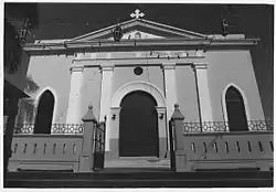 Church Nuestra Señora de la Candelaria y San Matías of Manatí |
September 18, 1984 (#84003130) |
Patriota Pozo Street, Town Plaza 18°25′38″N 66°29′33″W |
Manatí Pueblo | |
| 3 | La Colectiva Tabacalera |  La Colectiva Tabacalera |
September 1, 1988 (#88001305) |
18 Quiñones Street 18°25′40″N 66°29′31″W |
Manatí Pueblo | Industrial Neoclassic building from 1880 |
| 4 | Hacienda Azucarera la Esperanza |  Hacienda Azucarera la Esperanza |
August 11, 1976 (#76002190) |
Northwest of Manatí on Highway 616 18°28′03″N 66°31′31″W |
Tierras Nuevas Poniente | |
| 5 | Plaza del Mercado de Manatí | 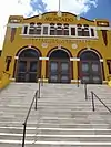 Plaza del Mercado de Manatí |
August 19, 1988 (#88001303) |
Quiñones, Padial and Baldorioty Streets 18°25′37″N 66°29′37″W |
Manatí Pueblo | Art Deco and Mission/Spanish Revival architecture from 1925, designed by Rafael Carmoega |
Quebradillas
| [2] | Name on the Register | Image | Date listed[3] | Location | Barrio | Description |
|---|---|---|---|---|---|---|
| 1 | Puente Blanco | 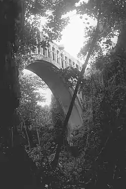 Puente Blanco |
February 23, 1984 (#84003126) |
Spanning Quebrada Mala Canyon on Panoramica Street 18°29′10″N 66°55′34″W |
Terranova | Bridge built in 1922 |
| 2 | Teatro Liberty | 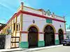 Teatro Liberty |
May 4, 1989 (#88000963) |
157 Rafols Street 18°28′24″N 66°56′21″W |
Quebradillas Pueblo | Building from 1921 designed by Arcilio Rosa |
San Sebastián
| [2] | Name on the Register | Image | Date listed[3] | Location | Barrio | Description |
|---|---|---|---|---|---|---|
| 1 | Church San Sebastián Mártir of San Sebastián | 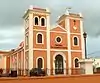 Church San Sebastián Mártir of San Sebastián |
September 18, 1984 (#84003132) |
Severo Arana Street, Town Plaza 18°20′12″N 66°59′26″W |
San Sebastián Pueblo |
Toa Alta
| [2] | Name on the Register | Image | Date listed[3] | Location | Barrio | Description |
|---|---|---|---|---|---|---|
| 1 | Church Nuestra Señora de la Concepción y San Fernando of Toa Alta | 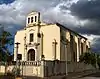 Church Nuestra Señora de la Concepción y San Fernando of Toa Alta |
September 18, 1984 (#84003158) |
Ponce de León Street, Town Plaza 18°23′18″N 66°14′50″W |
Toa Alta Pueblo | Church from 1752 |
Toa Baja
| [2] | Name on the Register | Image | Date listed[3] | Location | Barrio | Description |
|---|---|---|---|---|---|---|
| 1 | Ermita Nuestra Señora de la Candelaria del Plantaje | June 30, 2015 (#15000398) |
Highway 866 18°26′48″N 66°09′49″W |
Sabana Seca | ||
| 2 | Iglesia Parroquial de San Pedro Apostol de Toa Baja[lower-alpha 4] | 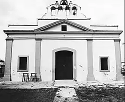 Iglesia Parroquial de San Pedro Apostol de Toa Baja |
April 17, 1975 (#75002135) |
47 Las Flores Street 18°26′33″N 66°15′18″W |
Toa Baja Pueblo | [9] |
| 3 | San Juan National Historic Site | San Juan National Historic Site |
October 15, 1966 (#66000930) |
Isla de Cabras[lower-alpha 5] 18°27′59″N 66°08′11″W |
Palo Seco | Dates from 1525 |
| 4 | Santa Elena Hacienda | .jpg.webp) Santa Elena Hacienda |
September 24, 1992 (#83004662) |
North of the junction of Highway 2 and Highway 165 18°25′50″N 66°15′28″W |
Media Luna |
Vega Alta
| [2] | Name on the Register | Image | Date listed[3] | Location | Barrio | Description |
|---|---|---|---|---|---|---|
| 1 | Church Inmaculada Conception of Vega Alta | 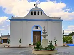 Church Inmaculada Conception of Vega Alta |
September 18, 1984 (#84003128) |
Town Plaza 18°24′43″N 66°19′45″W |
Vega Alta Pueblo | Church dating from 1831 |
Vega Baja
| [2] | Name on the Register | Image | Date listed[3] | Location | Barrio | Description |
|---|---|---|---|---|---|---|
| 1 | Casa Alonso | December 13, 1996 (#96001491) |
34 Betances Avenue 18°26′39″N 66°23′11″W |
Vega Baja Pueblo | ||
| 2 | Church Santa María del Rosario of Vega Baja | 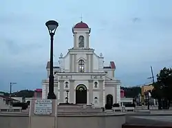 Church Santa María del Rosario of Vega Baja |
September 18, 1984 (#84003133) |
Town Plaza 18°26′40″N 66°23′12″W |
Vega Baja Pueblo | Church from 1860 |
| 3 | Panteón Otero-Martínez | July 30, 1984 (#84003135) |
Old Vega Baja Cemetery, Highway 670 18°26′41″N 66°23′35″W |
Algarrobo | A mausoleum | |
| 4 | Paso del Indio Site | July 25, 2007 (#07000583) |
Address restricted[10] |
Address restricted[10] | An archeological site |
See also
- National Register of Historic Places listings in Puerto Rico
- National Register of Historic Places listings in southern Puerto Rico
- National Register of Historic Places listings in western Puerto Rico
- National Register of Historic Places listings in eastern Puerto Rico
- National Register of Historic Places listings in central Puerto Rico
- National Register of Historic Places listings in metropolitan San Juan, Puerto Rico
- List of United States National Historic Landmarks in United States commonwealths and territories, associated states, and foreign states
- Historic preservation
- History of Puerto Rico
Notes
- The Stahl House's National Register of Historic Places nomination form gives a birth date of 1841 for Agustín Stahl,[4] while most other references, such as the Smithsonian Institution,[5] state 1842.
- The Plata Bridge spans the boundary between Bayamón (Barrio Dajaos) and Naranjito (Barrio Nuevo) municipalities.
- The name of the Iglesia Parroquial de San Pedro Martir de Guaynabo is presented here without the accent on "Mártir" in conformance with the usage in the church's National Register nomination form[6] and Federal Register announcement of listing.[7]
- The name of the Iglesia Parroquial de San Pedro Apostol de Toa Baja is presented here without the accent on "Apóstol" in conformance with the usage in the church's National Register nomination form[9] and Federal Register announcement of listing.[7]
- The National Register listing for the San Juan National Historic Site includes components in both San Juan and Toa Baja municipalities.
References
- "National Register of Historic Places: Weekly List Actions". National Park Service, United States Department of the Interior. Retrieved on January 29, 2021.
- Numbers represent an alphabetical ordering by significant words. Various colorings, defined here, differentiate National Historic Landmarks and historic districts from other NRHP buildings, structures, sites or objects.
- The eight-digit number below each date is the number assigned to each location in the National Register Information System database, which can be viewed by clicking the number.
- Llanes Santos, Juan (December 14, 2010), National Register of Historic Places Registration Form: Casa Dr. Agustín Stahl Stamm (PDF), archived from the original (PDF) on November 17, 2015, retrieved November 15, 2015.
- Acevedo-Rodrguez, P. (n.d.), "The Botanical Legacy of Agustín Stahl", Flora of Puerto Rico and the Virgin Islands, Smithsonian Institution, National Museum of Natural History, archived from the original on November 6, 2015, retrieved November 15, 2015.
- Tarr, J. Alexandra (1976), National Register of Historic Places Inventory — Nomination Form: Iglesia Parroquial de San Pedro Martir de Guaynabo (PDF), retrieved April 15, 2017.
- "Department of the Interior, Heritage Conservation and Recreation Service: National Register of Historic Places; Annual Listing of Historic Properties", 44 FR 7416 (February 6, 1979), at p. 7581.
- "Contáctenos", Corporación Mabodamaca, Inc., n.d., archived from the original on January 26, 2016, retrieved January 25, 2016.
- Davila, Arturo V. (March 27, 1975), National Register of Historic Places Inventory — Nomination Form: Iglesia Parroquial de San Pedro Apostol de Toa Baja (PDF), retrieved January 22, 2016.
- Federal and state laws and practices restrict general public access to information regarding the specific location of this resource. In some cases, this is to protect archeological sites from vandalism, while in other cases it is restricted at the request of the owner. See: Knoerl, John; Miller, Diane; Shrimpton, Rebecca H. (1990), Guidelines for Restricting Information about Historic and Prehistoric Resources, National Register Bulletin, National Park Service, U.S. Department of the Interior, OCLC 20706997.
External links
- Puerto Rico State Historic Preservation Office, National Register of Historic Places site (in Spanish)
- National Park Service, National Register of Historic Places site
 Media related to National Register of Historic Places in Puerto Rico at Wikimedia Commons
This article is issued from Wikipedia. The text is licensed under Creative Commons - Attribution - Sharealike. Additional terms may apply for the media files.