Puerto Rico Highway 129
PR-129 is a north–south (actually diagonal) highway in North-Central Puerto Rico, connecting the town of Lares with Arecibo. It crosses the northern karst country of the island. When traveling from the northern coast of Puerto Rico, PR-129 can be used to reach the Arecibo Observatory and the Camuy River Caverns Park.[4]
| ||||
|---|---|---|---|---|
| Route information | ||||
| Maintained by Puerto Rico DTPW | ||||
| Length | 43.2 km[1][2] (26.8 mi) | |||
| Existed | 1953[3]–present | |||
| Major junctions | ||||
| South end | ||||
| ||||
| North end | ||||
| Location | ||||
| Municipalities | Adjuntas, Lares, Camuy, Hatillo, Arecibo | |||
| Highway system | ||||
| ||||


Route description
It is a four-lane, divided highway in Arecibo, and a Super Two Highway in Hatillo, Camuy and Lares. It then merges with PR-111, being entirely unsigned throughout this section. It then heads south as a narrow, rural road, and ends at PR-135 near Adjuntas. Its speed limit is overall 45 miles per hour (72 km/h) through its highway section. It was originally a narrow, two lane road. Much of the original alignment is now PR-134.[5]
Major intersections
| Municipality | Location | km[1][2] | mi | Destinations | Notes |
|---|---|---|---|---|---|
| Adjuntas | Yahuecas | 43.2 | 26.8 | Southern terminus of PR-129 | |
| Yahuecas–Portillo line | 40.5 | 25.2 | |||
| Lares | Mirasol–Buenos Aires line | 34.6 | 21.5 | ||
| 30.5 | 19.0 | ||||
| Buenos Aires | 30.2 | 18.8 | |||
| Lares | 27.7 38.2[lower-alpha 1] | 17.2 23.7 | Eastern terminus of PR-111 concurrency | ||
| 35.2[lower-alpha 1] 27.6 | 21.9 17.1 | Western terminus of PR-111 concurrency; diamond interchange | |||
| Lares–Lares barrio-pueblo line | 27.6– 27.5 | 17.1– 17.1 | |||
| Piletas | 25.5– 25.4 | 15.8– 15.8 | |||
| 24.4– 24.3 | 15.2– 15.1 | ||||
| Callejones | 21.9 | 13.6 | |||
| Camuy | Quebrada | 18.8 | 11.7 | ||
| Hatillo | Bayaney | 17.6– 17.5 | 10.9– 10.9 | ||
| 15.4 | 9.6 | ||||
| 15.3– 15.2 | 9.5– 9.4 | ||||
| Campo Alegre | 10.1– 10.0 | 6.3– 6.2 | |||
| 9.0 | 5.6 | ||||
| 7.3 | 4.5 | ||||
| Arecibo | Hato Abajo–Hato Arriba line | 3.7 | 2.3 | ||
| Hato Abajo | 3.4 | 2.1 | |||
| 3.0 | 1.9 | PR-22 exits 77A and 77B; cloverleaf interchange | |||
| Hato Abajo–Arecibo barrio-pueblo line | 1.5 | 0.93 | |||
| 1.1 | 0.68 | ||||
| Arecibo barrio-pueblo | 0.0 | 0.0 | Northern terminus of PR-129 | ||
1.000 mi = 1.609 km; 1.000 km = 0.621 mi
| |||||
- Kilometer markers represent the distance along PR-111 rather than PR-129.
Gallery
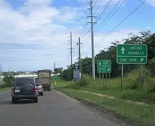
 Sign for Arecibo Observatory from PR-129 (northbound)
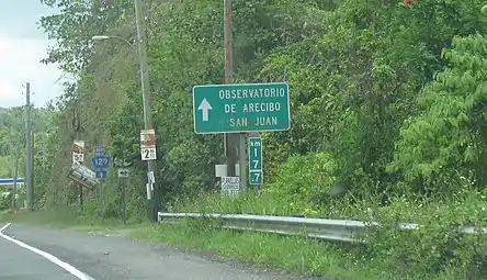
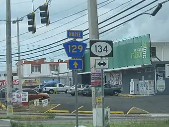 PR-134 junction sign in Bayaney barrio, Hatillo
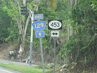 PR-453 junction sign in Lares, Puerto Rico
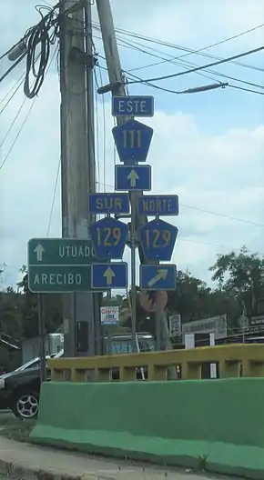 PR-111 and PR-129 Junction
See also
References
- Google (26 March 2020). "PR-129 north" (Map). Google Maps. Google. Retrieved 26 March 2020.
- Google (26 March 2020). "PR-129 south" (Map). Google Maps. Google. Retrieved 26 March 2020.
- "Hatillo, Memoria Núm. 63" (PDF). Puerto Rico Planning Board (in Spanish). 1954. Retrieved 4 August 2020.
- "Tránsito Promedio Diario (AADT)". Transit Data (Datos de Transito) (in Spanish). DTOP PR. pp. 174–175.
- National Geographic Maps (2011). Puerto Rico (Map). 1:125,000. Adventure Map. Evergreen, CO: National Geographic Maps. ISBN 978-1566955188. OCLC 756511572.
