Navajo Mountain, Utah
Navajo Mountain (Navajo: Naatsisʼáán) is a census-designated place (CDP) in San Juan County, Utah, United States. The population was 379 at the 2000 census.

Navajo Mountain, Utah
Naatsisʼáán | |
|---|---|
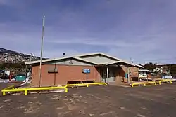 Naatsis'áán Chapter House | |
 Location on Navajo Mountain within San Juan County and the State of Utah. | |
| Coordinates: 37°2′58″N 110°46′26″W | |
| Country | United States |
| State | Utah |
| County | San Juan |
| Area | |
| • Total | 31.6 sq mi (81.8 km2) |
| • Land | 31.6 sq mi (81.8 km2) |
| • Water | 0.0 sq mi (0.0 km2) |
| Elevation | 6,024 ft (1,836 m) |
| Population (2000) | |
| • Total | 379 |
| • Density | 12.0/sq mi (4.6/km2) |
| Time zone | UTC-7 (Mountain (MST)) |
| • Summer (DST) | UTC-6 (MDT) |
| FIPS code | 49-53890[1] |
| GNIS feature ID | 1455975[2] |
The name of the mountain, Naatsisʼáán, means "Head of the Earth Woman" and is an important part of the Navajo creation story as is the adjacent Rainbow Bridge rock formation.
Geography
Navajo Mountain is located at 37°2′58″N 110°46′26″W (37.049409, -110.773998).[4]
According to the United States Census Bureau, the CDP has a total area of 31.6 square miles (81.8 km2), all land.
Demographics
As of the census[1] of 2000, there were 379 people, 93 households, and 79 families residing in the CDP. The population density was 12.0 people per square mile (4.6/km2). There were 120 housing units at an average density of 3.8/sq mi (1.5/km2). The racial makeup of the CDP was 96.83% Native American, 2.90% White and 0.26% from two or more races.
There were 93 households, out of which 51.6% had children under the age of 18 living with them, 59.1% were married couples living together, 20.4% had a female householder with no husband present, and 14.0% were non-families. 12.9% of all households were made up of individuals, and 6.5% had someone living alone who was 65 years of age or older. The average household size was 4.08 and the average family size was 4.55.
In the CDP, the population was spread out, with 44.9% under the age of 18, 10.6% from 18 to 24, 22.4% from 25 to 44, 14.8% from 45 to 64, and 7.4% who were 65 years of age or older. The median age was 21 years. For every 100 females, there were 101.6 males. For every 100 females age 18 and over, there were 93.5 males.
The median income for a household in the CDP was $14,196, and the median income for a family was $13,929. Males had a median income of $8,750 versus $23,750 for females. The per capita income for the CDP was $6,265. About 61.4% of families and 65.4% of the population were below the poverty line, including 78.6% of those under age 18 and 53.6% of those age 65 or over.
Education
The San Juan School District, the local public school district, operates Navajo Mountain High School.
A tribal school, NaaTsis'aan (Navajo Mountain) Community School, serves lower grades.[5]
A former school building was renovated and reopened as an arts education center.[6]
References
- "U.S. Census website". United States Census Bureau. Retrieved 2008-01-31.
- "US Board on Geographic Names". United States Geological Survey. 2007-10-25. Retrieved 2008-01-31.
- "US Gazetteer files: 2010, 2000, and 1990". United States Census Bureau. 2011-02-12. Retrieved 2011-04-23.
- "Contact Us." Naatsis'aan (Navajo Mountain) Community School. Retrieved on April 27, 2017.
- "Navajo Mountain School Project." California College of the Arts (CCA) Center for Art and Public Life. Retrieved on April 27, 2017.
External links
![]() Media related to Navajo Mountain, Utah at Wikimedia Commons
Media related to Navajo Mountain, Utah at Wikimedia Commons
Municipalities and communities of San Juan County, Utah, United States | ||
|---|---|---|
| Cities | 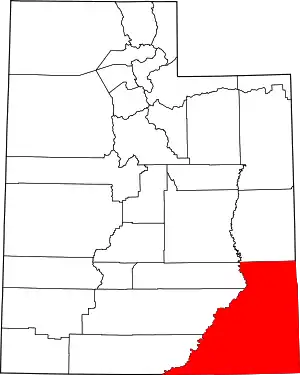 Map of Utah highlighting San Juan County | |
| Towns | ||
| CDPs | ||
| Unincorporated communities | ||
| Indian reservations | ||
| Ghost towns | ||
| Footnotes | ‡This populated place also has portions in an adjacent county or counties | |
| ||
| Tónaneezdizí (Western Agency) | |
|---|---|
| Chʼínílį́ (Chinle Agency) | |
| Tséhootsooí (Fort Defiance Agency) | |
| Naatʼáaniinééz (Shiprock Agency) | |
| Tʼiistsʼózí (Eastern Agency) | |