Greasewood, Arizona
Greasewood (Navajo: Díwózhii Biiʼ Tó) is a census-designated place (CDP) in Navajo County, Arizona, United States. The population was 547 at the 2010 census.[3]
Greasewood, Arizona | |
|---|---|
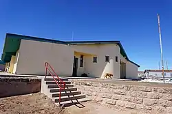 Greasewood Chapter House | |
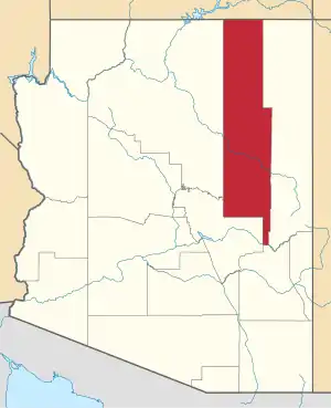
 Location in Navajo County and the state of Arizona | |
 Greasewood, Arizona Location in the United States | |
| Coordinates: 35°31′32″N 109°51′54″W | |
| Country | United States |
| State | Arizona |
| County | Navajo |
| Area | |
| • Total | 5.35 sq mi (13.85 km2) |
| • Land | 5.34 sq mi (13.84 km2) |
| • Water | 0.01 sq mi (0.01 km2) |
| Elevation | 5,910 ft (1,801 m) |
| Population (2010) | |
| • Total | 547 |
| • Estimate (2016)[2] | N/A |
| Time zone | UTC-7 (MST) |
| FIPS code | 04-29430 |
| GNIS feature ID | 0005336 |
Geography
Greasewood is located at 35°31′32″N 109°51′54″W (35.525467, -109.865005).[4]
According to the United States Census Bureau, the CDP has a total area of 5.3 square miles (14 km2), all of it land.
Demographics
| Historical population | |||
|---|---|---|---|
| Census | Pop. | %± | |
| 2000 | 581 | — | |
| 2010 | 547 | −5.9% | |
| U.S. Decennial Census[5] | |||
| Languages (2000) [6] | Percent |
|---|---|
| Spoke Navajo at home | 87.60% |
| Spoke English at home | 12.40% |
At the 2000 census there were 581 people, 126 households, and 106 families living in the CDP. The population density was 108.7 people per square mile (42.0/km²). There were 182 housing units at an average density of 34.1/sq mi (13.2/km²). The racial makeup of the CDP was 2.41% White, 97.07% Native American, 0.17% Pacific Islander, 0.17% from other races, and 0.17% from two or more races. 0.69% of the population were Hispanic or Latino of any race.[7] Of the 126 households 49.2% had children under the age of 18 living with them, 54.0% were married couples living together, 22.2% had a female householder with no husband present, and 15.1% were non-families. 13.5% of households were one person and 2.4% were one person aged 65 or older. The average household size was 4.12 and the average family size was 4.55.
The age distribution was 47.2% under the age of 18, 9.6% from 18 to 24, 24.3% from 25 to 44, 16.2% from 45 to 64, and 2.8% 65 or older. The median age was 19 years. For every 100 females, there were 91.7 males. For every 100 females age 18 and over, there were 95.5 males.
The median household income was $16,583 and the median family income was $20,234. Males had a median income of $28,333 versus $18,750 for females. The per capita income for the CDP was $5,490. About 42.2% of families and 43.6% of the population were below the poverty line, including 47.5% of those under age 18 and 35.3% of those age 65 or over.
Education
The area is served by the Ganado Unified School District and Holbrook Unified School District. Nearby Indian Wells Elementary School serves Greasewood.
Ganado Primary school, Ganado Elementary School, Ganado Middle School and Ganado High School in Ganado Az, Holbrook Junior High School and Holbrook High School, in Holbrook, serve Greasewood.
References
- "2016 U.S. Gazetteer Files". United States Census Bureau. Retrieved Jul 18, 2017.
- "Population and Housing Unit Estimates". Retrieved June 9, 2017.
- "American FactFinder". United States Census Bureau. Archived from the original on 2020-02-14. Retrieved 2018-10-05.
- "US Gazetteer files: 2010, 2000, and 1990". United States Census Bureau. 2011-02-12. Retrieved 2011-04-23.
- "Census of Population and Housing". Census.gov. Retrieved June 4, 2016.
- https://apps.mla.org/cgi-shl/docstudio/docs.pl?map_data_results
- "U.S. Census website". United States Census Bureau. Retrieved 2008-01-31.
| Tónaneezdizí (Western Agency) | |
|---|---|
| Chʼínílį́ (Chinle Agency) | |
| Tséhootsooí (Fort Defiance Agency) | |
| Naatʼáaniinééz (Shiprock Agency) | |
| Tʼiistsʼózí (Eastern Agency) | |