Neunkirchen-Seelscheid
Neunkirchen-Seelscheid is a municipality in the Rhein-Sieg district in the southern part of North Rhine-Westphalia, Germany. Beside the two principal places Neunkirchen and Seelscheid there are numerous smaller localities among the municipality.
Neunkirchen-Seelscheid | |
|---|---|
 Coat of arms | |
Location of Neunkirchen-Seelscheid within Rhein-Sieg-Kreis district 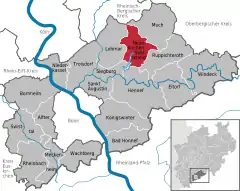 | |
 Neunkirchen-Seelscheid  Neunkirchen-Seelscheid | |
| Coordinates: 50°52′N 07°20′E | |
| Country | Germany |
| State | North Rhine-Westphalia |
| Admin. region | Köln |
| District | Rhein-Sieg-Kreis |
| Subdivisions | 59 |
| Government | |
| • Mayor | Nicole Sander (SPD) |
| Area | |
| • Total | 50.64 km2 (19.55 sq mi) |
| Elevation | 220 m (720 ft) |
| Population (2019-12-31)[1] | |
| • Total | 19,679 |
| • Density | 390/km2 (1,000/sq mi) |
| Time zone | UTC+01:00 (CET) |
| • Summer (DST) | UTC+02:00 (CEST) |
| Postal codes | 53819 |
| Dialling codes | 02247 |
| Vehicle registration | SU |
| Website | www.nk-se.de |
Geography
Neunkirchen-Seelscheid is located 20 km north-east of Bonn and 25 km south-east from Cologne in the southern part of the region of Berg (Bergisches Land). The northwest municipality border is formed by the river course of the Naafbach, while the Bröl acts as the southeast border. The Wahnbach flows through the municipality.
Neighbour municipalities
Neighbouring cities are Siegburg, Hennef, Overath and Lohmar. Neighbouring municipalities are Much and Ruppichteroth.
Subdivisions
Beside the two principal places Neunkirchen (5423) and Seelscheid (5788) there are following localities within the municipality (population between brackets)
Balensiefen (20), Birken (58), Birkenfeld (174), Birkenmühle (5), Brackemich (106), Breiderheide (3), Breitscheid, Bruchhausen (59), Busch (14), Effert (2), Eich (101), Eischeid (508), Gutmühle (39), Hardt (43), Hasenbach (315), Hausen, Hausermühle (71), Heidgen, Heister (110), Herkenrath (137), Hermerath (342), Hermerather Mühle, Herrenwiesermühle, Hochhausen (397), Hohn (101), Höfferhof, Hülscheid (418), Ingersau (62), Ingersaueler Mühle (6), Kaule (37), Kotthausen, Köbach (112), Krahwinkel (200), Meisenbach, Mohlscheid (383), Nackhausen (319), Niederhorbach (164), Niederwennerscheid (507), Oberdorst (364), Oberheister (413), Oberhorbach (64), Oberste Zeith, Oberwennerscheid (432), Ohlig (10), Ohmerath (31), Pinn (45), Pixhof, Pohlhausen (492), Rehwiese (6), Remschoß (254), Rengert (222), Renzert (64), Rippert (128), Schaaren, Scherpekotten (2), Scherpemich, Schöneshof (454), Siefen (34), Söntgerath (134), Stein (125), Steinermühle (19), Straßen (84), Unterste Zeith, Wahlen (22), Wahn (197), Weiert (32), Wende (4), Weesbach, Wiescheid, Wolperath (1288)
Population
- 1998 – 19.515
- 1999 – 19.874
- 2000 – 20.079
- 2001 – 20.328
- 2002 – 20.674
- 2003 – 20.898
- 2004 – 21.020
- 2005 – 21.000
- 2006 – 20.946
- 2007 – 20.902
- 2008 – 20.868
- 2009 – 20.855
- 2010 – 20.822
- 2011 - 20.756
- 2012 – 20.613
- 2013 – 20.497
- 2014 – 20.593
- 2015 – 20.958
- 2016 – 20.158
- 2017 - 19.758
History
- ca. 5000 BC - first remains of human settlement
- 1178 - first documentary mention
- 1969 Neunkirchen-Seelscheid were made of the two old municipalities Neunkirchen and Seelscheid
Politics
The 34 seats of the municipal council consist of:
- CDU - 16 seats
- SPD - 9 seats
- FDP - 5 seats
- The Greens - 4 seats
Twin towns
Sons and daughters
- Andreas Pinkwart (born 1960), German politician (FDP)
References
- "Bevölkerung der Gemeinden Nordrhein-Westfalens am 31. Dezember 2019" (in German). Landesbetrieb Information und Technik NRW. Retrieved 17 June 2020.
| Authority control |
|---|
