Niger River
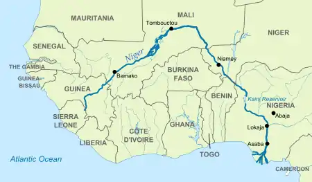
The Niger River (/ˈnaɪdʒər/; French: (le) fleuve Niger, pronounced [(lə) flœv niʒɛʁ]) is the principal river of West Africa, extending about 4,180 km (2,600 mi). Its drainage basin is 2,117,700 km2 (817,600 sq mi) in area.[3] Its source is in the Guinea Highlands in southeastern Guinea. It runs in a crescent through Mali, Niger, on the border with Benin and then through Nigeria, discharging through a massive delta, known as the Niger Delta[4] (or the Oil Rivers), into the Gulf of Guinea in the Atlantic Ocean. The Niger is the third-longest river in Africa, exceeded only by the Nile and the Congo River (also known as the Zaïre River). Its main tributary is the Benue River.
.jpg.webp) The Pont Kennedy across the Niger at Niamey in February 2019 | |
 | |
| Etymology | Unknown (likely from Berber for River Gher) |
| Location | |
| Countries | |
| Cities | |
| Physical characteristics | |
| Source | Guinea Highlands |
| • location | Guinea |
| Mouth | Atlantic Ocean |
• location | Gulf of Guinea, Nigeria |
| Length | 4,180 km (2,600 mi) |
| Basin size | 2,117,700 km2 (817,600 sq mi) |
| Discharge | |
| • location | Niger Delta[1] |
| • average | 5,589 m3/s (197,400 cu ft/s)[1] |
| • minimum | 500 m3/s (18,000 cu ft/s) |
| • maximum | 27,600 m3/s (970,000 cu ft/s)[2] |
| Basin features | |
| Tributaries | |
| • left | Sokoto River, Kaduna River, Benue River, Anambra River |
| • right | Bani River, Mékrou River |
%252C_scene_at_the_river_front.jpg.webp)
Etymology
The Niger has different names in the different languages of the region:
- Manding: Jeliba ߖߋߟߌߓߊ or Joliba ߖߏߟߌߓߊ "great river"
- Igbo: Orimiri or Orimili "great water"
- Tuareg: Egerew n-Igerewen ⴻⴳⴻⵔⴻⵡ ⵏⵉⴳⴻⵔⴻⵡⴻⵏ "river of rivers"
- Songhay: Isa "the river"
- Ijaw: Toru Beni "the river water"
- Zarma: Isa Beeri "great river"[5]
- Hausa: Kwara كوَرَ
- Yoruba: Oya
- Fula: Maayo Jaaliba 𞤃𞤢𞥄𞤴𞤮 𞤔𞤢𞥄𞤤𞤭𞤦𞤢
The earliest use of the name "Niger" for the river is by Leo Africanus in his Della descrittione dell’Africa et delle cose notabili che ivi sono published in Italian in 1550. The name may come from Berber phrase ger-n-ger meaning "river of rivers".[6] As Timbuktu was the southern end of the principal Trans-Saharan trade route to the western Mediterranean, it was the source of most European knowledge of the region.
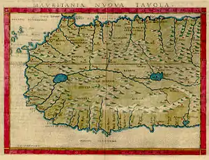
Medieval European maps applied the name Niger to the middle reaches of the river, in modern Mali, but Quorra (Kworra) to the lower reaches in modern Nigeria, as these were not recognized at the time as being the same river. When European colonial powers began to send ships along the west coast of Africa in the 16th and 17th centuries, the Senegal River was often postulated to be the seaward end of the Niger. The Niger Delta, pouring into the Atlantic through mangrove swamps and thousands of distributaries along more than 160 kilometres (100 miles), was thought to be no more than coastal wetlands. It was only with the 18th-century visits of Mungo Park, who travelled down the Niger River and visited the great Sahelian empires of his day, that Europeans correctly identified the course of the Niger and extended the name to its entire course.
The modern nations of Nigeria and Niger take their names from the river, marking contesting national claims by colonial powers of the "Upper", "Lower" and "Middle" Niger river basin during the Scramble for Africa at the end of the 19th century.
Geography
The Niger River is a relatively "clear" river, carrying only a tenth as much sediment as the Nile because the Niger's headwaters lie in ancient rocks that provide little silt.[7] Like the Nile, the Niger floods yearly; this begins in September, peaks in November, and finishes by May.[7]
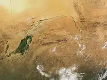
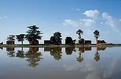
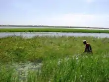
An unusual feature of the river is the Inner Niger Delta, which forms where its gradient suddenly decreases.[7] The result is a region of braided streams, marshes, and lakes the size of Belgium; the seasonal floods make the Delta extremely productive for both fishing and agriculture.[8]
The river loses nearly two-thirds of its potential flow in the Inner Delta between Ségou and Timbuktu to seepage and evaporation. All the water from the Bani River, which flows into the Delta at Mopti, does not compensate for the 'losses'. The average 'loss' is estimated at 31 km3/year, but varies considerably between years.[9] The river is then joined by various tributaries, but also loses more water to evaporation. The quantity of water entering Nigeria measured in Yola was estimated at 25 km3/year before the 1980s and at 13.5 km3/year during the 1980s. The most important tributary of the Niger in Nigeria is the Benue River which merges with the river at Lokoja in Nigeria. The total volume of tributaries in Nigeria is six times higher than the inflow into Nigeria, with a flow near the mouth of the river standing at 177.0 km3/year before the 1980s and 147.3 km3/year during the 1980s.[9]
Unusual route
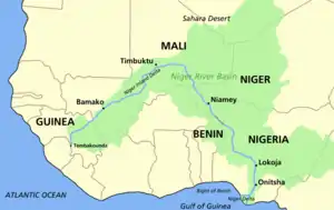
The Niger takes one of the most unusual routes of any major river, a boomerang shape that baffled geographers for two centuries. Its source (Tembakounda) is just 240 km (150 mi) inland from the Atlantic Ocean, but the river runs directly away from the sea into the Sahara Desert, then takes a sharp right turn near the ancient city of Timbuktu (Tombouctou) and heads southeast to the Gulf of Guinea.
This strange geography apparently came about because the Niger River is two ancient rivers joined together. The upper Niger, from the source west of Timbuktu to the bend in the current river near Timbuktu, once emptied into a now dry lake to the east northeast of Timbuktu, while the lower Niger started to the south of Timbuktu and flowed south into the Gulf of Guinea. Over time upstream erosion by the lower Niger resulted in stream capture of the upper Niger by the lower Niger.[10]
The northern part of the river, known as the Niger bend, is an important area because it is the major river and source of water in that part of the Sahara desert. This made it the focal point of trade across the western Sahara, and the centre of the Sahelian kingdoms of Mali and Gao.
The surrounding Niger River Basin is one of the distinct physiographic sections of the Sudan province, which in turn is part of the larger African massive physiographic division.
History
At the end of the African Humid Period around 5,500 years before present, the modern Sahara Desert, once a savanna, underwent desertification. As plant species sharply declined,[11] humans migrated to the fertile Niger River bend region, with abundant resources including plants for grazing and fish.[12] Like in the Fertile Crescent, many food crops were domesticated in the Niger River region, including yams, African rice (Oryza glaberrima), and pearl millet.[13] The Sahara aridification may have triggered, or at least accelerated, these domestications.[11] Agriculture, as well as fishing and animal husbandry, led to the rise of settlements like Djenné-Djenno in the Inner Delta, now a World Heritage Site.[14]
The region of the Niger bend, in the Sahel, was a key origin and destination for trans-Saharan trade, fueling the wealth of great empires such as the Ghana, Mali, and Songhai Empires. Major trading ports along the river, including Timbuktu and Gao, became centers of learning and culture. Trade to the Niger bend region also brought Islam to the region in approximately the 14th century CE. Much of the northern Niger basin remains Muslim today, although the southern reaches of the river tend to be Christian.
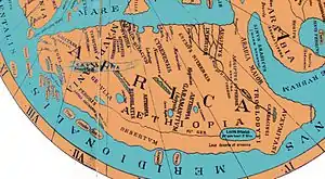
Classical writings on the interior of the Sahara begins with Ptolemy, who mentions two rivers in the desert: the "Gir" (Γειρ)[15] and farther south, the "Nigir" (Νιγειρ).[16][17] The first has been since identified as the Wadi Ghir on the north western edge of the Tuat, along the borders of modern Morocco and Algeria.[16][18] This would likely have been as far as Ptolemy would have had consistent records. The Ni-Ger was likely speculation, although the name stuck as that of a river south of the Mediterranean's "known world". Suetonius reports Romans traveling to the "Ger", although in reporting any river's name derived from a Berber language, in which "gher" means "watercourse", confusion could easily arise.[19] Pliny connected these two rivers as one long watercourse which flowed (via lakes and underground sections) into the Nile,[20] a notion which persisted in the Arab and European worlds – and further added the Senegal River as the "Ger" – until the 19th century.
While the true course of the Niger was presumably known to locals, it was a mystery to the outside world until the late 18th century. Ancient Romans such as Pliny (N.H. 5.10) thought that the river near Timbuktu was part of the Nile River, a belief also held by Ibn Battuta, while early European explorers thought that it flowed west and joined the Senegal River. The connection to the Nile River was made not simply because this was then known as the great river of "Aethiopia" (by which all lands south of the desert were called by Classical writers), but because the Nile like the Niger flooded every summer. [21] Through the descriptions of Leo Africanus and even Ibn Battuta – despite his visit to the river – the myth connecting the Niger to the Nile persisted.
Many European expeditions to plot the river were unsuccessful.[22] In 1788 the African Association was formed in England to promote the exploration of Africa in the hopes of locating the Niger, and in June 1796 the Scottish explorer Mungo Park was the first European to lay eyes on the middle portion of the river since antiquity (and perhaps ever). He wrote a famous account Travels in the Interior of Africa, which appeared in 1799.[23] Park proposed a theory that the Niger and Congo were the same river. Although the Niger Delta would seem like an obvious candidate, it was a maze of streams and swamps that did not look like the head of a great river. He died in 1806 on a second expedition attempting to prove the Niger-Congo connection.[24] The theory became the leading one in Europe.[24] A number of failed expeditions followed however the mystery of the Niger would not be solved for another 25 years, in 1830, when Richard Lander and his brother became the first Europeans to follow the course of the Niger to the ocean.[24]
On October 24, 1946 three Frenchmen, Jean Sauvy, Pierre Ponty and movie maker Jean Rouch, former civil servants in the African French colonies, set out to travel the entire length of the river, as no one else seemed to have done previously. They travelled from the very beginning of the river near Kissidougou in Guinea, walking at first till a raft could be used, then changing to various local crafts as the river broadened and changed. Two of them reached the ocean on March 25, 1947, with Pierre Ponty having had to leave the expedition at Niamey, somewhat past the halfway mark. They carried a 16mm movie camera, the resulting footage giving Jean Rouch his first two ethnographic documentaries: "Au pays des mages noirs", and "La chasse à l’hippopotame". A camera was used to illustrate Jean Rouch's subsequent book "Le Niger En Pirogue" (Fernand Nathan, 1954), as well as Jean Sauvy's “Descente du Niger” (L'Harmattan 2001). A typewriter was brought as well, on which Pierre Ponty produced newspaper articles he mailed out whenever possible.[25]
Management and development
The water in the Niger River basin is partially regulated through dams. In Mali the Sélingué Dam on the Sankarani River is mainly used for hydropower, but also permits irrigation. Two diversion dams, one at Sotuba just downstream of Bamako, and one at Markala, just downstream of Ségou, are used to irrigate about 54,000 hectares.[9] In Nigeria the Kainji Dam, Shiroro Dam, newly Zungeru Dam and the Jebba dam are used to generate hydropower.
The water resources of the Niger River are under pressure due to increased water abstraction for irrigation and due to the impact of climate change. The construction of dams for hydropower generation is underway or envisaged in order to alleviate chronic power shortages in the countries of the Niger basin.[26]
The FAO estimates the irrigation potential of all countries in the Niger river basin at 2.8 million hectares. Only 0.93m hectares (ha) were under irrigation in the late 1980s. The irrigation potential was estimated at 1.68m ha in Nigeria 0.56m ha in Mali, and the actual irrigated area was 0.67m ha and 0.19m ha.[9]
Niger Basin Charta and Investment Plan
In order to further coordinate their efforts, in April 2008 the riparian countries which form the Niger Basin Authority adopted a Niger Basin Water Charta, a basin-wide 30-year investment plan and a 5-year priority investment plan. The Charta promotes Integrated Water Resources Management, defines procedures for the examination and approval of new projects, provides a framework for the allocation of water resources between sectors, commits to maintain the integrity of aquatic ecosystems and defines mechanisms for the settlement of disputes between countries and for user participation. Investments include the expansion of irrigated agriculture to improve food security, the construction of the Taoussa (or Tossaye) dam in Mali and the Kandadji Dam in Niger (the latter has been under construction since August 2008), as well as the rehabilitation of the Kainji dam, Shiroro Dam, Jebba dam and the newly Zungeru Dam in Nigeria.[lower-alpha 1]
Funding
Most of the investments are funded or are expected to be funded through aid. For example, the Kandadji Dam is financed by the Islamic Development Bank, the African Development Bank and the OPEC Development Fund. The World Bank approved a US$500 million soft loan in July 2007 to finance projects in the basin over a 12-year period. Funding will be awarded in two phases. The initial $185 million credit will go to Nigeria, Guinea, Benin, Mali and Niger. The second, $315 million investment, is slated for Burkina Faso, Cameroon, Chad and Ivory Coast.[29] Besides financing the rehabilitation of dams in Nigeria, the loan will also fund the "sustainable management of selected degraded ecosystems and rehabilitation of small water infrastructure" and capacity building.[30]
River transport and dredging
In September 2009, the Nigerian government commenced a 36 billion naira dredging of the Niger River from Baro to Warri, a move which will see silt removed from several hundred kilometres.[31] The dredging is intended to make it easier for goods to be transported to isolated settlements located deep within from the Atlantic Ocean.[31] Estimated to be completed within six to eight months, it had first been proposed and then postponed for 43 years previously by the then government.[31][32] Speaking in Lokoja, Nigerian President Umaru Yar'Adua stated that the project would lead to "all-year-round navigability" on the River Niger and that he hoped that, by 2020, Nigeria would have become one of the twenty most industrialised nations in the world.[31][32] Alhaji Ibrahim Bio, the Nigerian Minister of Transport, said his ministry would work to make certain the project would be completed within its designated timeframe.[32] Some activists have, however, opposed the project in the past, claiming it may have negative effects on waterside villagers.[31]
In late March 2010 the dredging project was 50% complete.[33]
See also
- Azawagh – Dry basin that once carried a northern tributary of the Niger River
- Niger Basin Authority – Intergovernmental organization in West Africa aiming to foster co-operation in managing and developing the resources of the Niger River Basin
- The River Niger - 1972 play
Notes
References
- "WWD Continents". www.geol.lsu.edu. Archived from the original on 8 October 2017. Retrieved 28 April 2018.
- Castano, Ing. Antonio. "A STUDY ON THE HYDROLOGICAL SERIES OF THE NIGER RIVER AT KOULIKORO, NIAMEY AND LOKOJA STATIONS". webcache.googleusercontent.com. Retrieved 28 April 2018.
- Gleick, Peter H. (2000), The World's Water, 2000-2001: The Biennial Report on Freshwater, Island Press, p. 33, ISBN 978-1-55963-792-3; online at Internet Archive
- "Rivers of the World: the Niger River", Radio Netherlands Archives, December 4, 2002
- Idrissa, Abdourahmane; Decalo, Samuel (June 1, 2012), Historical Dictionary of Niger (4th ed.), Plymouth, UK: Scarecrow Press, p. 274, ISBN 978-0810860940
- Hunwick, John O. (2003) [1999]. Timbuktu and the Songhay Empire: Al-Sadi's Tarikh al-Sudan down to 1613 and other contemporary documents. Leiden: Brill. p. 275 Fn 22. ISBN 978-90-04-11207-0.
- Reader 2001, p. 191.
- Reader 2001, pp. 191–192.
- FAO:Irrigation potential in Africa: A basin approach, The Niger Basin Archived 2017-07-21 at the Wayback Machine, 1997
- Tom L. McKnight; Darrel Hess (2005). "16, "The Fluvial Processes"". Physical Geography: A Landscape Appreciation (8th ed.). Upper Saddle River, New Jersey: Pearson, Prentice Hall. p. 462. ISBN 978-0-13-145139-1.
- Cubry, Philippe (2018). "The Rise and Fall of African Rice Cultivation Revealed by Analysis of 246 New Genomes". Current Biology. 28 (14): 2274‐2282. doi:10.1016/j.cub.2018.05.066. PMID 29983312.
- Mayor, Anne. "Ceramic Traditions and Ethnicity in the Niger Bend, West Africa". ResearchGate. University of Geneva.
- Scarcelli, Nora (2019). "Yam genomics supports West Africa as a major cradle of crop domestication" (PDF). Science Advances. 5 (5): eaaw1947. Bibcode:2019SciA....5.1947S. doi:10.1126/sciadv.aaw1947. PMC 6527260. PMID 31114806.
- Mcintosh, Susan Keech; Mcintosh, Roderick J. (Oct 1979). "Initial Perspectives on Prehistoric Subsistence in the Inland Niger Delta (Mail)". World Archaeology. 11 (2 Food and Nutrition): 227–243. doi:10.1080/00438243.1979.9979762. PMID 16470987.
- Geographia, Book IV, Chapter 6, Section 13.
- Meek, C. K. (1960). "The Niger and the Classics: The History of a Name". Journal of African History. 1 (1): 1–17. doi:10.1017/S0021853700001456. JSTOR 179702.
- Law, R. C. C. (1967). "The Garamantes and Trans-Saharan Enterprise in Classical Times". Journal of African History. 8 (2): 181–200. doi:10.1017/S0021853700007015.. Law carefully ties together the classical sources on this, and explains the mix of third hand reports and mythology that was current in both the European and Arab worlds.
- Edward Herbert Bunbury, William H. Stahl. A History of Ancient Geography Among the Greeks and Romans: From the Earliest Ages Till the Fall of the Roman Empire J. Murray, London (1879) pp.626–627
- Thomson 1948, pp. 258–259.
- Thomson 1948, p. 258.
- Law (1967) pp.182–4
- Plumb, 1952.
- de Gramonte, Sanche (1991), The Strong Brown God: Story of the Niger River, Houghton Mifflin, ISBN 978-0-395-56756-2
- Maclachlan, T. Banks (1898). Mungo Park. Edinburgh: Oliphant, Anderson & Ferrier. pp. 130–142.
- Baugh, Brenda, About Jean Rouch, Documentary Education Resources, archived from the original on 2009-08-20, retrieved 27 Jan 2010
- "In the Niger Basin, Countries Collaborate on Hydropower, Irrigation and Improved Water Resource Management". World Bank. Archived from the original on 2017-09-20. Retrieved 2017-09-20.
- "Archived copy". Archived from the original on 2011-09-03. Retrieved 2010-01-09.CS1 maint: archived copy as title (link)
- "Archived copy" (PDF). Archived (PDF) from the original on 2011-07-20. Retrieved 2010-01-09.CS1 maint: archived copy as title (link)
- Voice of America: RSS Feed World Bank Sending $500 Million Funding for Niger Basin Development Archived 2011-08-04 at the Wayback Machine, July 4, 2007
- World Bank:Niger Basin Water Resources Development and Sustainable Ecosystems Management Project, accessed on January 9, 2010 Archived June 12, 2011, at the Wayback Machine
- "Nigeria begins vast river dredge". BBC. 2009-09-10. Archived from the original on 2009-09-13. Retrieved 2009-09-11.
- Wole Ayodele (2009-09-09). "Yar'Adua Flags off Dredging of River Niger". This Day Online. Archived from the original on 2009-09-14. Retrieved 2009-09-11.http://allafrica.com/stories/200909110317.html
- "N36bn River Niger dredging project 50% completed – FG". Punch on the web. 2010-03-25. Archived from the original on 2011-10-02. Retrieved 2010-05-11."Archived copy". Archived from the original on 2015-11-26. Retrieved 2015-11-25.CS1 maint: archived copy as title (link)
Sources
- Plumb, J. H. "The Niger Quest" History Today (1952) 2#4 pp 243-251. online
- Reader, John (2001), Africa, Washington, D.C.: National Geographic Society, ISBN 978-0-620-25506-6
- Thomson, J. Oliver (1948), History of Ancient Geography, Biblo & Tannen Publishers, ISBN 978-0-8196-0143-8
- Welcomme, R.L. (1986), "The Niger River System", in Davies, Bryan Robert; Walker, Keith F. (eds.), The Ecology of River Systems, Springer, pp. 9–60, ISBN 978-90-6193-540-7
External links
- Information and a map of the Niger's watershed http://www.wri.org/resources
- Map of the Niger River basin at Water Resources eAtlas (link broken)
- Niger Currents: Exploring life and technology along the Niger River
- Pierre Maas and Geert Mommersteeg, Fishing in the Pondo, 1990, Saudi Aramco World
International law and the Niger River
- Bibliography on Water Resources and International Law Peace Palace Library
- Fabio Spadi, "The ICJ Judgment in the Benin-Niger Border Dispute: the interplay of titles and ‘effectivités’ under the uti possidetis juris principle", Leiden Journal of International Law https://openaccess.leidenuniv.nl/handle/1887/13541(2005) 4, pp. 777–794.
| Countries | 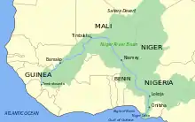 | |
|---|---|---|
| Sections |
| |
| Tributaries (list) and distributaries | ||
| Cities | ||
| Lakes | ||
| Dams and bridges | ||
| Protected Areas | ||