Nordwestuckermark
Nordwestuckermark is a municipality in the Uckermark district, in Brandenburg, Germany.
Nordwestuckermark | |
|---|---|
 Coat of arms | |
Location of Nordwestuckermark within Uckermark district 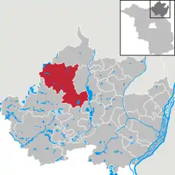 | |
 Nordwestuckermark  Nordwestuckermark | |
| Coordinates: 53°23′N 13°40′E | |
| Country | Germany |
| State | Brandenburg |
| District | Uckermark |
| Government | |
| • Mayor | Sylvia Klingbeil |
| Area | |
| • Total | 253.14 km2 (97.74 sq mi) |
| Elevation | 80 m (260 ft) |
| Population (2019-12-31)[1] | |
| • Total | 4,194 |
| • Density | 17/km2 (43/sq mi) |
| Time zone | UTC+01:00 (CET) |
| • Summer (DST) | UTC+02:00 (CEST) |
| Postal codes | 17291 |
| Dialling codes | 039852, 039859 |
| Vehicle registration | UM |
| Website | www.gemeinde-nordwestuckermark.de |
History and community structure
The community Nordwestuckermark was formed on 1 November 2001 from the previously independent municipalities Ferdinandshorst, Fürstenwerder, Gollmitz, Kraatz, Naugarten, Röpersdorf/Sternhagen, Schapow, Schönermark und Weggun (Amt Nordwestuckermark) and the municipality Holzendorf (department Prenzlau-Land).
The community Nordwestuckermark has the following districts:
|
|
|
Demography
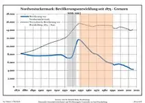 Development of population since 1875 within the current Boundaries (Blue Line: Population; Dotted Line: Comparison to Population development in Brandenburg state; Grey Background: Time of Nazi Germany; Red Background: Time of communist East Germany)
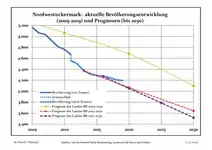 Recent Population Development and Projections (Population Development before Census 2011 (blue line); Recent Population Development according to the Census in Germany in 2011 (blue bordered line); Official projections for 2005-2030 (yellow line); for 2014-2030 (red line); for 2017-2030 (scarlet line)
|
|
|
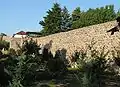
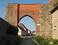
Photo gallery
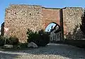
- Fürstenwerder
See also
- Fürstenwerder
- Großer See
References
- "Bevölkerung im Land Brandenburg nach amtsfreien Gemeinden, Ämtern und Gemeinden 31. Dezember 2019". Amt für Statistik Berlin-Brandenburg (in German). July 2020.
- Detailed data sources are to be found in the Wikimedia Commons.Population Projection Brandenburg at Wikimedia Commons
Towns and municipalities in Uckermark | ||
|---|---|---|
| Coat of Arms of Uckermark district | |
| Wikimedia Commons has media related to Nordwestuckermark. |
| Authority control |
|---|
This article is issued from Wikipedia. The text is licensed under Creative Commons - Attribution - Sharealike. Additional terms may apply for the media files.