Randowtal
Randowtal is a municipality in the Uckermark district, in Brandenburg, Germany.
Randowtal | |
|---|---|
Location of Randowtal within Uckermark district  | |
 Randowtal  Randowtal | |
| Coordinates: 53°17′53″N 14°02′00″E | |
| Country | Germany |
| State | Brandenburg |
| District | Uckermark |
| Municipal assoc. | Gramzow |
| Government | |
| • Mayor | Eva-Maria Christ |
| Area | |
| • Total | 63.71 km2 (24.60 sq mi) |
| Elevation | 55 m (180 ft) |
| Population (2019-12-31)[1] | |
| • Total | 914 |
| • Density | 14/km2 (37/sq mi) |
| Time zone | UTC+01:00 (CET) |
| • Summer (DST) | UTC+02:00 (CEST) |
| Postal codes | 17291 |
| Dialling codes | 039857, 039862 |
| Vehicle registration | UM |
| Website | www.amtgramzow.de |
Demography
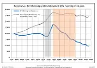
Development of population since 1875 within the current boundaries (Blue line: Population; Dotted line: Comparison to population development of Brandenburg state; Grey background: Time of Nazi rule; Red background: Time of communist rule)
|
|
|
References
- "Bevölkerung im Land Brandenburg nach amtsfreien Gemeinden, Ämtern und Gemeinden 31. Dezember 2019". Amt für Statistik Berlin-Brandenburg (in German). July 2020.
- Detailed data sources are to be found in the Wikimedia Commons.Population Projection Brandenburg at Wikimedia Commons
![]() Media related to Randowtal at Wikimedia Commons
Media related to Randowtal at Wikimedia Commons
Towns and municipalities in Uckermark | ||
|---|---|---|
| Coat of Arms of Uckermark district | |
This article is issued from Wikipedia. The text is licensed under Creative Commons - Attribution - Sharealike. Additional terms may apply for the media files.
