North Dakota Highway 8
North Dakota Highway 8 (ND 8) is a 211.321-mile (340.088 km) north–south state highway in North Dakota, United States. The highway is split into two segments. The southern segment is 133 miles (214 km) long and travels from Lake Sakakawea near Twin Buttes to South Dakota Highway 75 (SD 75) near Hettinger. The northern segment is 78 miles (126 km) long and travels from Saskatchewan Highway 9 (SK 9) in Northgate on the Canada–United States border to ND 23 near New Town. The highway was originally continuous but was separated by the formation of Lake Sakakawea in the 1950s.
| ||||
|---|---|---|---|---|
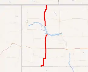
ND 8 highlighted in red | ||||
| Route information | ||||
| Maintained by NDDOT | ||||
| Length | 211.321 mi[1] (340.088 km) | |||
| Major junctions | ||||
| South end | ||||
| North end | ||||
| Location | ||||
| Counties | ||||
| Highway system | ||||
| ||||
.svg.png.webp)
Route description
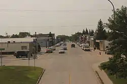
ND 8 in Stanley, August 2013
Major intersections
| County | Location | mi[1] | km | Destinations | Notes | ||
|---|---|---|---|---|---|---|---|
| Adams | | 0.000 | 0.000 | Southern terminus; continuation into South Dakota as South Dakota Highway 75 | |||
| | 4.035 | 6.494 | Southern end of US 12 concurrency | ||||
| | 12.119 | 19.504 | Northern end of US 12 concurrency | ||||
| Hettinger | | 37.816 | 60.859 | Southern end of ND 21 concurrency | |||
| Mott | 45.583 | 73.359 | Northern end of ND 21 concurrency | ||||
| Stark | Richardton | 80.312 | 129.250 | I-94 exit 84. | |||
| Dunn | | 112.215 | 180.593 | Southern end of ND 200 overlap | |||
| Halliday | 113.807 | 183.155 | Northern end of ND 200 overlap | ||||
| | 121.912 | 196.198 | |||||
| Fort Berthold Indian Reservation | 132.120 | 212.627 | Road ends near Lake Sakakawea | ||||
| Gap in route | |||||||
| Mountrail | Fort Berthold Indian Reservation | 132.121 | 212.628 | Route resumes | |||
| Stanley | 155.962 | 250.997 | |||||
| Mountrail–Burke county line | | 173.390 | 279.044 | Southern end of ND 50 overlap | |||
| Burke | | 174.140 | 280.251 | Northern end of ND 50 overlap | |||
| Bowbells | 197.124 | 317.240 | Southern end of US 52 / ND 5 overlap | ||||
| | 203.888 | 328.126 | Northern end of US 52 / ND 5 overlap | ||||
| Northgate Border Crossing | 211.321 | 340.088 | Canada–United States border | ||||
| Continuation into Canada | |||||||
1.000 mi = 1.609 km; 1.000 km = 0.621 mi
| |||||||
References
- "Route and Mileage Map Insets" (PDF). North Dakota Department of Transportation. North Dakota Department of Transportation. Retrieved June 20, 2016.
External links
| Wikimedia Commons has media related to North Dakota Highway 8. |
- The North Dakota Highways Page by Chris Geelhart
- North Dakota Signs by Mark O'Neil
This article is issued from Wikipedia. The text is licensed under Creative Commons - Attribution - Sharealike. Additional terms may apply for the media files.