North East, Pennsylvania
North East is a borough in Erie County, Pennsylvania, United States, 14 miles (23 km) northeast of Erie. Located in the northwestern corner of the state, it is so named because it lies in the county's northeastern corner. Fruit growing was an early economic endeavor, and is still to this day, as this is a popular area especially for cherries and grapes. There is an annual Cherry Festival in the summer and an annual Wine Country Harvest Festival in autumn. It contains one junior college, Mercyhurst North East. The population was 4,294 at the 2010 census,[5] down from 4,601 at the 2000 census. It is part of the Erie Metropolitan Statistical Area. It is the northernmost town in Pennsylvania.
North East, Pennsylvania | |
|---|---|
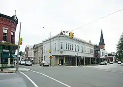
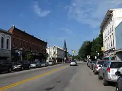 Main Street, looking west toward Lake Street (Pennsylvania Route 89) | |
| Etymology: North East Township | |
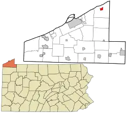 Location in Erie County and the U.S. state of Pennsylvania. | |
| Coordinates: 42°12′48″N 79°50′1″W | |
| Country | United States |
| State | Pennsylvania |
| County | Erie |
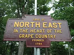
| Settled | 1794 |
| Incorporaated | February 27, 1834 |
| Founded by | Joseph Shadduck[1] |
| Government | |
| • Mayor | Steve Gregory |
| Area | |
| • Total | 1.30 sq mi (3.37 km2) |
| • Land | 1.30 sq mi (3.37 km2) |
| • Water | 0.00 sq mi (0.00 km2) |
| Elevation [3] (Borough benchmark) | 802 ft (244 m) |
| Highest elevation [3] (southeast corner of borough) | 870 ft (270 m) |
| Lowest elevation | 740 ft (230 m) |
| Population (2010) | |
| • Total | 4,294 |
| • Estimate (2019)[4] | 4,033 |
| • Density | 3,095.17/sq mi (1,195.14/km2) |
| Time zone | UTC-4 (EST) |
| • Summer (DST) | UTC-5 (EDT) |
| ZIP code | 16428 |
| Area code(s) | 814 |
| Website | northeastborough |
History
Before 1650, the area was settled by the Eriez, a relatively peaceful tribe; however, they were destroyed by the Seneca.[6]
As part of the Erie Triangle, it was only in 1792 that the locale became part of Pennsylvania. However, North East did not receive its first settler until 1794, still several years before the county (Erie) and township (North East) were organized. Originally the North East Township was called "Lower Greenfield" being downstream from Greenfield Township. The first road was built in 1797 from present day Freeport at the mouth of Sixteenmile Creek to present day Colt Station now in Greenfield Township. That road was extended in 1798 to where French Creek forks (present day Wattsburg).[7] In 1798 the first school was formed.[6][8] In 1800 a road from the village of North East to Wattsburg was opened, it paralleled, but ran east of, the first one from Freeport.[9] In 1801 the first church was organized, it was Presbyterian.[8]
In 1884 a fire destroyed two-thirds of the town's business district.[10]
In 1983 Short's Hotel was listed on the National Register of Historic Places. In 1990 the entire old central business district was added to the register.[11]
Geography
North East is located in northeastern Erie County at 42°12′48″N 79°50′1″W (42.213385, -79.833711).[12] It is surrounded by North East Township.
According to the United States Census Bureau, the borough has a total area of 1.3 square miles (3.4 km2), all of it land.[5]
National Register of Historic Places
Demographics
| Historical population | |||
|---|---|---|---|
| Census | Pop. | %± | |
| 1850 | 387 | — | |
| 1860 | 566 | 46.3% | |
| 1870 | 900 | 59.0% | |
| 1880 | 1,396 | 55.1% | |
| 1890 | 1,538 | 10.2% | |
| 1900 | 2,068 | 34.5% | |
| 1910 | 2,672 | 29.2% | |
| 1920 | 3,481 | 30.3% | |
| 1930 | 3,670 | 5.4% | |
| 1940 | 3,704 | 0.9% | |
| 1950 | 4,247 | 14.7% | |
| 1960 | 4,217 | −0.7% | |
| 1970 | 3,846 | −8.8% | |
| 1980 | 4,568 | 18.8% | |
| 1990 | 4,617 | 1.1% | |
| 2000 | 4,601 | −0.3% | |
| 2010 | 4,294 | −6.7% | |
| 2019 (est.) | 4,033 | [4] | −6.1% |
| Sources:[13][14][15] | |||
As of the census[14] of 2000, there were 4,601 people, 1,730 households, and 1,162 families residing in the borough. The population density was 3,515.4 people per square mile (1,356.1/km2). There were 1,795 housing units at an average density of 1,371.5 per square mile (529.0/km2). The racial makeup of the borough was 97.65% White, 0.80% African American, 0.09% Native American, 0.09% Asian, 0.59% from other races, and 0.78% from two or more races. Hispanic or Latino of any race were 1.87% of the population.
There were 1,730 households, out of which 35.7% had children under the age of 18 living with them, 48.9% were married couples living together, 14.4% had a female householder with no husband present, and 32.8% were non-families. 29.3% of all households were made up of individuals, and 14.1% had someone living alone who was 65 years of age or older. The average household size was 2.53 and the average family size was 3.12.
In the borough the population was spread out, with 27.5% under the age of 18, 11.2% from 18 to 24, 27.0% from 25 to 44, 20.3% from 45 to 64, and 13.9% who were 65 years of age or older. The median age was 34 years. For every 100 females there were 94.5 males. For every 100 females age 18 and over, there were 87.9 males.
The median income for a household in the borough was $36,431, and the median income for a family was $43,250. Males had a median income of $33,939 versus $21,921 for females. The per capita income for the borough was $16,132. About 10.0% of families and 13.6% of the population were below the poverty line, including 18.3% of those under age 18 and 11.9% of those age 65 or over.
Economy
North East's economy is primarily based on grapes. Vineyards carpet the township, and there are at least five large wineries in the area. One of the borough's largest employers is Welch's.
References
- Whitman, Benjamin; et al. (1884). History of Erie County, Pennsylvania: Containing a History of the County, Its Townships, Towns, Villages, Schools, Churches, Industries, Etc. 1. Erie, Pennsylvania. p. 724.
- "2019 U.S. Gazetteer Files". United States Census Bureau. Retrieved July 28, 2020.
- "Grahamville Reservoir Topo Map, Erie County PA (North East Area)". TopoZone. Locality, LLC. Retrieved September 2, 2019.
- "Population and Housing Unit Estimates". United States Census Bureau. May 24, 2020. Retrieved May 27, 2020.
- "Geographic Identifiers: 2010 Demographic Profile Data (G001): North East borough, Pennsylvania". American Factfinder. U.S. Census Bureau. Archived from the original on February 13, 2020. Retrieved March 16, 2016.
- "Location & History - North East Borough".
- Whitman 1884, p. 729
- Whitman 1884, p. 725
- "Transportation Plan". Greenfield Township Comprehensive Plan (PDF). Greenfield Township, Erie County. 2002. p. 5.
- Sands, Patricia A.; Sisson, William (August 1989). "National Register of Historic Places Inventory Nomination Form: North East Historic District" (PDF). Retrieved November 5, 2018.
- "National Register Information System". National Register of Historic Places. National Park Service. July 9, 2010.
- "US Gazetteer files: 2010, 2000, and 1990". United States Census Bureau. February 12, 2011. Retrieved April 23, 2011.
- "Census of Population and Housing". U.S. Census Bureau. Retrieved December 11, 2013.
- "U.S. Census website". United States Census Bureau. Retrieved January 31, 2008.
- "Incorporated Places and Minor Civil Divisions Datasets: Subcounty Resident Population Estimates: April 1, 2010 to July 1, 2012". Population Estimates. U.S. Census Bureau. Archived from the original on June 11, 2013. Retrieved December 11, 2013.
Further reading
- Gallagher, Marty. (1985) North East Past, North East, Pennsylvania: The North East Breeze Publishing Co. (Brown-Thompson Newspapers, Inc.) OCLC 21961951 (compilation of newspaper articles)
- Green, Walter R. (1981) North East, Pennsylvania 1850-1890, Erie, Pennsylvania: Mercyhurst College.
- Loop, Admah Irwin (1984) One hundred years of North East, North East, Pennsylvania: The North East Breeze Publishing Co. (Brown-Thompson Newspapers, Inc.) OCLC 21879061 (compilation of newspaper articles from 1934 to 1937)
External links
| Wikimedia Commons has media related to North East, Pennsylvania. |
Municipalities and communities of Erie County, Pennsylvania, United States | ||
|---|---|---|
| Cities | 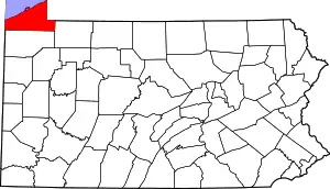 | |
| Boroughs | ||
| Townships | ||
| CDPs | ||
| Unincorporated communities | ||
| ||
| Authority control |
|---|