Oak Flats, New South Wales
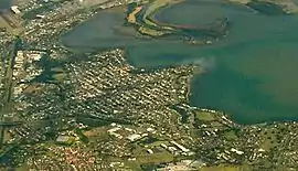
Oak Flats is a suburb of Shellharbour, New South Wales, Australia situated on the south western shores of Lake Illawarra and within the Illawarra region of New South Wales. It is a residential area, which had a population of 6,415 at the 2016 census.[1]
| Oak Flats New South Wales | |
|---|---|
 Aerial view of Oak Flats from the east | |
 Oak Flats | |
| Coordinates | 34°33′43″S 150°49′08″E |
| Population | 6,415 (2016 census)[1] |
| • Density | 1,783/km2 (4,620/sq mi) |
| Established | 1831 |
| Postcode(s) | 2529 |
| Elevation | 14 m (46 ft) |
| Area | 3.590 km2 (1.4 sq mi) |
| Time zone | AEST (UTC+10) |
| • Summer (DST) | AEDT (UTC+11) |
| Location | |
| LGA(s) | City of Shellharbour |
| Region | Illawarra |
| County | Camden |
| Parish | Terragong |
| State electorate(s) | Shellharbour |
| Federal Division(s) | Whitlam |
Oak Flats is one of the 324 suburbs that sits within the Wollongong Statistical District which covers the local authority areas of Wollongong, Shellharbour and Kiama. Oak Flats is locally governed by the Shellharbour City Council which governs 22 suburbs within the area.
History
The Indigenous people of Yuin are the traditional owners of the South Coast. Traces of Aboriginal occupation of Oak Flats date back to around 15,000 BC.
The area was discovered by George Bass and Matthew Flinders in 1796, whilst free settlers arrived in the nearby town of Shellharbour between 1817 and 1831. As the population in the suburbs around Oak Flats grew, the need for more residential areas became more important. The eastern end of the suburb is commonly known as Balarang.
Ownership of area was first as a grant of 1,200 acres to army officer John Horsley in 1821. The grant was situated on the southern shores of Lake Illawarra and known as the 'Oak Flats Run'. The land was used to run cattle in the area. Development of Oak Flats as a suburb began in 1925 with the Lake Illawarra Township Estate as the centre, followed by the Kembla Vista and Panorama Estates. Economic Depression of the 1930s coupled with the onset of WWII, slowed development. Post WWII migration brought immigrants predominantly Dutch, and German to Oak Flats, and the town began to develop rapidly.[2]
In the early 1930s, Sydney newspapers invited holiday makers to the therapeutic waters of Lake Illawarra as an alternative to spas in the Blue Mountains. Visitors to Oak Flats initially stayed in the two-storey guesthouse on the Boulevarde. Blocks were also purchased and small week-enders erected by visitors keen to return to Lake Illawarra as a holiday destination. A boat shed, where rowing boats could be hired, stood on the end of the small point at Central Park. The shoreline was popular on hot summer days when families would congregate on the grassy banks to rest or swim in the Lake.[3]
Many streets of Oak Flats are named after Australian prime ministers. These include Deakin Street and Barton Street.
Demographics
Oak Flats is located in southeast New South Wales and had a population of around 6,415 (49.1% male, 50.9% female) at the 2016 census. Around 1819 families lived in the area and of those 40.7% had one or more children under the age of 15. 19.6% of families had only a single parent while 38.6% of couples had no children.[1] Oak Flats covers an area of approximately 359 hectares (887 acres).
Of the 2,317 private dwellings in Oak Flats 42.6% were owned outright by their occupiers, 33.2% were being purchased (e.g. by mortgage) and 21.5% were being rented. On average there were around 2.6 people per private dwelling in the area. The composition of occupied private dwellings in Oak Flats was as follows: 85.9% separate houses, 11.7% semi-detached houses (e.g. townhouses, row or terrace houses), 1.5% flats (including units and apartments).[1]
In terms of people aged 15 years or more living in Oak Flats 48.8% were married, 9.6% were divorced, 4.3% were separated, 6.2% were widowed and 31.0% had never married.[1]
| Country of birth | Number | Percentage of total inhabitants |
|---|---|---|
| Australia | 4,963 | 77.8% |
| England | 349 | 5.5% |
| Germany | 109 | 1.7% |
| New Zealand | 51 | 0.8% |
| Macedonia | 46 | 0.7% |
| Scotland | 39 | 0.6% |
Geography
Oak Flats varies in altitude/elevation from about −4 m (highlight point) to 36 m (highlight point) above sea level.
The postcode for Oak Flats is 2529.
Neighbouring suburbs/regional areas of Oak Flats include Albion Park Rail, Albion Park, Blackbutt and Mount Warrigal.
Education
Oak Flats has four major schools within its boundaries, including Balarang Primary, Oak Flats Primary School, Oak Flats High School and Corpus Christi Catholic High School.
Oak Flats High School
Oak Flats High School is a government-funding secondary school located which was opened on a 20 hectare site on the eastern end of the suburb in 1962. It has 760 enrolments and provides education to children between year 7 and year 12.
Balarang Public School
Balarang Public School was opened in 1968 in a four hectare landscape in Oak Flats. It is located right next to Oak Flats High School. The school provides education to children between Kindergarten and year 6 and draws 30% of its enrolments from other surrounding suburbs. The name of the school is an Indigenous meaning for 'place of swamp oak'.
Corpus Christi Catholic High School
Corpus Christi Catholic High School is a Catholic co-educational school which opened in 2006 with its first group of Year 7 students. The students are drawn from the parishes extending from Port Kembla in the north to Kiama in the south. Since the opening, Corpus Christi has grown to become a Years 7–12 school.
Oak Flats Public School
Oak Flats public school is the first school to open in the area of Oak Flats. It provides education and supervision for children between Kindergarten and Year 6. The school also provides pre-school.
Churches
Oak Flats Anglican Church began services in a house in 1947 before moving to the current premises at 35 Fisher Street, Oak Flats, in 1951.
Transport

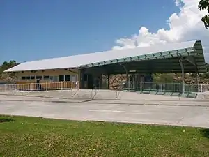
Oak Flats has its own rail station on the NSW TrainLink South Coast line. There is also a bus station/bus stop at the rail station for interchanging with trains.
Recreational
Oak Flats contains two cricket grounds (Shane Lee Oval, Geoff Shaw Oval and Brett Lee Oval), two soccer grounds (Keith Bond Oval and Panorama Oval), and one tennis court.
Notable people
- Cricketers Shane and Brett Lee
- [Danny Roberts][Rugby fullback] [Erotic Film Star]
References
- Australian Bureau of Statistics (27 June 2017). "Oak Flats". 2016 Census QuickStats. Retrieved 14 July 2017.

- "Place Names of Shellharbour City" (PDF). Archived from the original (PDF) on 21 March 2012. Retrieved 7 April 2013.
- "Shellharbour Images". Retrieved 4 April 2013.