Okhahlamba Local Municipality
Okhahlamba Local Municipality is a municipality in the Uthukela District Municipality, KwaZulu-Natal, South Africa.
Okhahlamba | |
|---|---|
 Seal | |
.svg.png.webp) Location in KwaZulu-Natal | |
| Coordinates: 28°44′S 29°22′E | |
| Country | South Africa |
| Province | KwaZulu-Natal |
| District | uThukela |
| Seat | Bergville |
| Wards | 14 |
| Government | |
| • Type | Municipal council |
| • Mayor | Mlungisi Ndlangisa |
| Area | |
| • Total | 3,971 km2 (1,533 sq mi) |
| Population (2011)[2] | |
| • Total | 132,068 |
| • Density | 33/km2 (86/sq mi) |
| Racial makeup (2011) | |
| • Black African | 97.1% |
| • Coloured | 0.2% |
| • Indian/Asian | 0.4% |
| • White | 2.1% |
| First languages (2011) | |
| • Zulu | 93.2% |
| • English | 2.0% |
| • Southern Ndebele | 1.2% |
| • Afrikaans | 1.0% |
| • Other | 2.6% |
| Time zone | UTC+2 (SAST) |
| Municipal code | KZN235 |
Society and culture
Spion Kop
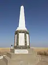
This large battlefield located some 30 km outside Ladysmith contains the mass graves of British soldiers, individual graves as well as a number of memorials, including a Boer memorial, British memorial, South Lancashire memorial and Imperial Light Infantry memorial.
Spioenkop Nature Reserve
25 kilometres (16 mi) from Ladysmith is one of South Africa’s popular wildlife sanctuaries, Spioenkop Nature Reserve. This 60 square kilometres (23 sq mi) reserve is home to animals such as the rhino, giraffe and zebra. The sporting activities that Spioenkop offers include hiking, horse riding, angling, yachting, water-skiing and power boating. Spioenkop is also supplies other parts of Gauteng with water because in Gauteng there is a shortage of water.
Main places
The 2001 census divided the municipality into the following main places:[4]
| Place | Code | Area (km2) | Population |
|---|---|---|---|
| Amangwane | 51701 | 737.10 | 67,829 |
| Amazizi | 51702 | 95.71 | 16,010 |
| Bergville Part 1 | 51703 | 80.11 | 27,670 |
| Bergville Part 2 | 51715 | 2.53 | 702 |
| Drakensberg | 51704 | 0.40 | 75 |
| Driefontein, KwaZulu-Natal | 51705 | 1.41 | 231 |
| Estcourt | 51706 | 4.79 | 988 |
| Geluksburg | 51707 | 1.08 | 209 |
| Jagersrust | 51708 | 0.63 | 199 |
| Northern Natal Drakensberg | 51709 | 142.17 | 3 |
| Rugged Glen Nature Reserve | 51711 | 7.66 | 15 |
| Spioenkop Dam Nature Reserve | 51712 | 41.63 | 48 |
| Van Reenen | 51713 | 0.48 | 78 |
| Winterton | 51714 | 1.81 | 2,186 |
| Remainder of the municipality | 51710 | 2,365.82 | 21,277 |
Politics
The municipal council consists of twenty-nine members elected by mixed-member proportional representation. Fifteen councillors are elected by first-past-the-post voting in fifteen wards, while the remaining fourteen are chosen from party lists so that the total number of party representatives is proportional to the number of votes received. In the election of 3 August 2016 the African National Congress (ANC) won a majority of fifteen seats on the council.
The following table shows the results of the election.[5][6]
| Party | Votes | Seats | ||||||
|---|---|---|---|---|---|---|---|---|
| Ward | List | Total | % | Ward | List | Total | ||
| ANC | 17,722 | 18,697 | 36,419 | 52.3 | 14 | 1 | 15 | |
| IFP | 7,844 | 7,869 | 15,713 | 22.6 | 1 | 6 | 7 | |
| Congress of the People | 3,633 | 3,599 | 7,232 | 10.4 | 0 | 3 | 3 | |
| Democratic Alliance | 1,984 | 1,990 | 3,974 | 5.7 | 0 | 2 | 2 | |
| Economic Freedom Fighters | 1,241 | 1,155 | 2,396 | 3.4 | 0 | 1 | 1 | |
| African Independent Congress | 1,117 | 1,207 | 2,324 | 3.3 | 0 | 1 | 1 | |
| Independent | 1.427 | – | 1,427 | 2.1 | 0 | – | 0 | |
| Peoples Revolutionary Movement | 30 | 149 | 179 | 0.3 | 0 | 0 | 0 | |
| Total | 34,998 | 34,666 | 69,664 | 100.0 | 15 | 14 | 29 | |
| Spoilt votes | 1,051 | 1,131 | 2,182 | |||||
References
- "Contact list: Executive Mayors". Government Communication & Information System. Archived from the original on 14 July 2010. Retrieved 22 February 2012.
- "Statistics by place". Statistics South Africa. Retrieved 27 September 2015.
- "Statistics by place". Statistics South Africa. Retrieved 27 September 2015.
- Lookup Tables - Statistics South Africa
- "Results Summary – All Ballots: Okhahlamba" (PDF). Independent Electoral Commission. Retrieved 6 January 2017.
- "Seat Calculation Detail: Okhahlamba" (PDF). Independent Electoral Commission. Retrieved 6 January 2017.
.svg.png.webp)