Oman–United Arab Emirates border
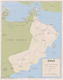
The Oman–United Arab Emirates border consists of three non-contiguous sections totalling 609 km (378 m) in length.[1]

Description
Northern (Musandam) section
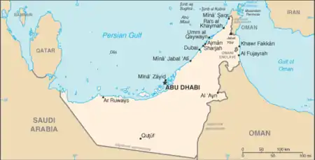
The northern section of border divides the Omani exclave of Musandam from the UAE Emirates of Fujairah and Ras Al Khaimah. This peninsula commands the strategic Strait of Hormuz, with the Oman-UAE border consisting of a series of irregular, though roughly horizontal, lines running through mountainous terrain, from the western Persian Gulf coast to the eastern Gulf of Oman coast.
Middle (enclaved) section
The middle section of the border consists of the Omani enclave of Madha, within which is the UAE counter-enclave of Nahwa, belonging to the Emirate of Sharjah.
Southern section
The southern, and by far the longest section, of the frontier starts in the north on the Oman Gulf coast, just south of Kalba in the Emirate of Sharjah. It then proceeds inland roughly south-westwards via a series of irregular lines, arcing southwards so as to include Hatta within the UAE; the border then proceeds roughly south-westwards down to the Omani tripoint, save for a piece of Emirati territory south-east of Al-Ain that juts into Oman.
History

During the 19th century Britain had signed a number of protectorate treaties with seven emirates on what was then known as the 'Pirate Coast', giving rise to the so-called Trucial States. Britain also exercised protectorate control over Oman via its sultan.[2] Boundaries in this part of Arabia remained indistinct; Britain and the Ottoman Empire theoretically divided their realms of influence in Arabia via the so-called 'Blue' and 'Violet lines' in 1913-14, however these agreements were rendered null and void following the collapse of the Ottoman Empire after the First World War.[3][4]
The enclaves of Madha and Nahwa appear to have arisen in the 1930s-40, following a dispute over the ownership of the area between Oman and the local emirs, which was settled by a vote amongst the village elders.[5] The boundaries of the enclaves were fixed in 1969.[5]
In the 1950s Britain appointed Julian Walker to survey more precise boundaries between the Trucial States and Oman.[6][7] However by the time of independence of the Trucial States (as the United Arab Emirates) in 1971, much of the border remained undemarcated, resulting in several disputes. The Ras Al Khaimah section of the boundary was settled in 1979 after a dispute arose in 1977-78 following the discovery of oil in the area.[7][8] Relations between the two states warmed in the 1980s-90s, resulting in a border agreement for the southern section of the frontier in 1999, followed by a complete border delimitation ratified in Abu Dhabi on 22 June 2002.[8]
Barrier
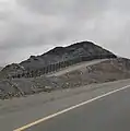
In 2002, the UAE announced that it was installing a fence along the UAE-Oman border (minus the Madha-Nahwa enclaves)[9] in an effort to curb the flow of illegal migrants, illicit drugs[10] and terrorists into the country.[11] The barrier constructed is a 12-foot barbed wire border fence.[12]
In 2003, Oman introduced an exit toll on crossing to the UAE border. In July 2004, Oman and the UAE jointly launched a three-day coordinated crackdown in and around Al Buraimi and arrested approximately 1,000 illegal immigrants.[12]
Settlements near the border
Oman
- Tibat
- Quroon as Said
- Dibba Al-Baya
- Al Wajajah
- Aswad
- A'Tuvayah
- Hadf
- Al-Buraimi
- Mahdah
- Hamasa
- Al Qabil
- Sahl al Arba
- Safah
- Al Khuwayr
UAE
- Sha'am
- Al Jeer
- Dibba Al-Fujairah
- Dibba Al-Hisn
- Shis
- Qidfa
- Sayh Mudayrah
- Mirbah
- Wahla
- Al Nasla
- Mosfuj
- Al Qor
- Fili
- Al Madam
- Shwaib
- Al Ain
- Al Ghafan
- Mezyad
- Al Arad
- Al Qua’a
- Umm az Zamul
Border Crossings
There are two border crossings on the Musandam section of the border (Tibat and Dibba)[13] and four on the main southern section (Hatta/Al Wajajah, Hilli, Jebel Hafeet and Khatmat Malaha).[14] There are no border controls at the Madha-Nahwa enclaves.[15]
Gallery
 Border barrier between UAE and Oman as seen from the Emirati side.
 The barrier between Dibba Al-Hisn and Dibba Al-Baya as seen from the Emirati side.
See also
References
- CIA World Factbook – Oman, retrieved 30 March 2020
- Dr Francis Owtram (11 December 2014). "A Close Relationship: Britain and Oman Since 1750". QDL. 2014.
- Briton Cooper Busch, Britain and the Persian Gulf, 1894-1914 (Berkeley: University of California Press,1967), 308, and 319.
- Richard Schofield (31 March 1999), Negotiating the Saudi-Yemeni international boundary, Al-Bab, retrieved 30 March 2020
- "Madha village's pledge of allegiance changed the map forever". The National. Retrieved 2018-01-05.
- Hesam Mohammed Jalil Sultan Al-Ulama (June 1994). The Federal Boundaries of the United Arab Emirates. Department of Geography, University of Durham. pp. 144–55.
- "Arabian Boundary Disputes - Cambridge Archive Editions". Archiveeditions.co.uk. Archived from the original on 2008-04-23. Retrieved 2017-01-21.
- Marc Valeri, Oman: Politics and Society in the Qaboos State, C Hurst and Co, 2009, pgs. 76-7
- Madha
- "United Arab Emirates 2007 Crime & Safety Report". Overseas Security Advisory Council. March 20, 2007. Retrieved 2007-06-05.
- Borger, Julian; Editor, Diplomatic. "Security fences or barriers to peace?". the Guardian. Retrieved 2015-09-21.CS1 maint: extra text: authors list (link)
- Garrard, John; Mikhailova, Ekaterina (21 August 2018). Twin Cities: Urban Communities, Borders and Relationships over Time. New York: Routledge. p. 22. ISBN 9781138098008.
- (2016) Tony Walsh and Diana Darke, Bradt Guide Book to Oman, pg. 171-72
- (2016) Tony Walsh and Diana Darke, Bradt Guide Book to Oman, pg. 46
- (2016) Tony Walsh and Diana Darke, Bradt Guide Book to Oman, pg. 178