One Mile, New South Wales
One Mile is a suburb of the Port Stephens local government area in the Hunter Region of New South Wales, Australia.[4] The Worimi people are the traditional owners of the Port Stephens area. [5]The suburb is semi-rural with a small urban settlement, several eco-resorts and back-packer accommodation to the west of Gan Gan Road. On the beach side there is a residential land-lease community (Middlerock Home Village) and three tourist parks. The parks, two of which have licensed restaurants, are positioned to provide quick access to the suburb's two beaches.[6] Since late 2017 Port Stephens Koala Hospital has been operating in the grounds of Treescape resort and is currently undergoing a major expansion.
| One Mile New South Wales | |||||||||||||||
|---|---|---|---|---|---|---|---|---|---|---|---|---|---|---|---|
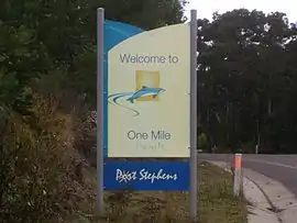 Road sign at the northern entrance to One Mile | |||||||||||||||
 Road signs identifying suburb as both One Mile and (incorrectly) One Mile Beach | |||||||||||||||
One Mile | |||||||||||||||
| Coordinates | 32°46′S 152°6.76′E | ||||||||||||||
| Population | 413 (2016 census)[1] | ||||||||||||||
| • Density | 58.9/km2 (153/sq mi) | ||||||||||||||
| Postcode(s) | 2316 | ||||||||||||||
| Area | 4.7 km2 (1.8 sq mi)[Note 1] | ||||||||||||||
| Time zone | AEST (UTC+10) | ||||||||||||||
| • Summer (DST) | AEDT (UTC+11) | ||||||||||||||
| Location |
| ||||||||||||||
| LGA(s) | Port Stephens Council | ||||||||||||||
| Region | Hunter | ||||||||||||||
| County | Gloucester[2] | ||||||||||||||
| Parish | Tomaree[2] | ||||||||||||||
| State electorate(s) | Port Stephens | ||||||||||||||
| Federal Division(s) | Paterson | ||||||||||||||
| |||||||||||||||
| |||||||||||||||
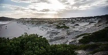
One Mile Beach, after which the area was named, is a family-friendly surf beach that is popular with tourists while Samurai Beach is clothing optional. Both beaches, like a large percentage of the locality, lie within the Tomaree National Park. The beaches form most of the coastline in Anna Bay which gave the adjacent suburb of Anna Bay its name.[7] The One Mile Surf Club includes a kiosk, barbecue and picnics area as well as public amenities.[8]
Although the suburb is formally called One Mile residents often refer to it as One Mile Beach. Until 2016, even some road signs identified the area incorrectly as One Mile Beach.
Notes
- Area calculation is based on 1:100000 map 9232 NEWCASTLE.
References
- Australian Bureau of Statistics (27 June 2017). "One Mile (State Suburb)". 2016 Census QuickStats. Retrieved 3 May 2018.

- "One Mile (suburb)". Geographical Names Register (GNR) of NSW. Geographical Names Board of New South Wales. Retrieved 31 May 2008.
- "Nelson Bay (Nelson Head)". Climate statistics for Australian locations. Bureau of Meteorology. Retrieved 2 June 2008.
- "Suburb Search - Local Council Boundaries - Hunter (HT)". New South Wales Division of Local Government. Archived from the original on 7 June 2008. Retrieved 31 May 2008.
- "Aboriginal and Torres Strait Islander people". Port Stephens Council.
- "One Mile". Land and Property Management Authority - Spatial Information eXchange. New South Wales Land and Property Information. Retrieved 31 May 2008.
- "Anna Bay (bay)". Geographical Names Register (GNR) of NSW. Geographical Names Board of New South Wales. Retrieved 31 May 2008.
- "One Mile Beach Reserve". www.portstephens.nsw.gov.au. Retrieved 16 October 2020.
![]() Media related to One Mile, New South Wales at Wikimedia Commons
Media related to One Mile, New South Wales at Wikimedia Commons
External links
- One Mile Beach - Beachsafe Surf Life Saving Website
- Samurai Beach - Beachsafe Surf Life Saving Website
- Port Stephens Koala Hospital Port Stephens Koalas Website
Coastal bays and inlets of New South Wales, Australia | |
|---|---|
| North of Sydney Harbour |
|
| Within Sydney Harbour | |
| South of Sydney Harbour | |
| |