Soldiers Point, New South Wales
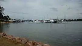
Soldiers Point is a suburb of the Port Stephens local government area in the Hunter Region of New South Wales, Australia.[2] Located on the southern shores of Port Stephens it is almost entirely surrounded by the port and is a popular location for fishing and boating.[7][8] While primarily residential, like other suburbs around Port Stephens, it is a popular tourist destination, especially in summer months.
| Soldiers Point New South Wales | |||||||||||||||
|---|---|---|---|---|---|---|---|---|---|---|---|---|---|---|---|
 Soldiers Point marina | |||||||||||||||
 Soldiers Point | |||||||||||||||
| Coordinates | 32°42′24″S 152°04′04″E | ||||||||||||||
| Population | 1,326 (2011 census)[1] | ||||||||||||||
| • Density | 1,326/km2 (3,430/sq mi) | ||||||||||||||
| Postcode(s) | 2317 | ||||||||||||||
| Area | 1 km2 (0.4 sq mi)[Note 1] | ||||||||||||||
| Time zone | AEST (UTC+10) | ||||||||||||||
| • Summer (DST) | AEDT (UTC+11) | ||||||||||||||
| Location |
| ||||||||||||||
| LGA(s) | Port Stephens Council[2] | ||||||||||||||
| Region | Hunter[2] | ||||||||||||||
| County | Gloucester[3] | ||||||||||||||
| Parish | Tomaree[3] | ||||||||||||||
| State electorate(s) | Port Stephens[4] | ||||||||||||||
| Federal Division(s) | Paterson[5] | ||||||||||||||
| |||||||||||||||
| |||||||||||||||
Soldiers Point was originally the site of a garrison of soldiers that was established in 1820 to hunt down escaped convicts.[9]
In July 2016, the New South Wales government declared 5.9 ha (14.6 acres) of the suburb as an Aboriginal place, recognising that Soldiers Point was a special place for cultural, spiritual and historic reasons to the Worimi people.[10]
Notes
- Area calculation is based on 1:100000 map 9232 NEWCASTLE.
References
- Australian Bureau of Statistics (31 October 2012). "Soldiers Point (State Suburb)". 2011 Census QuickStats. Retrieved 18 October 2012.

- "Suburb Search - Local Council Boundaries - Hunter (HT) - Port Stephens". New South Wales Division of Local Government. Retrieved 14 June 2008.
- "Soldiers Point". Geographical Names Register (GNR) of NSW. Geographical Names Board of New South Wales. Retrieved 14 June 2008.

- "Port Stephens". New South Wales Electoral Commission. Retrieved 23 November 2019.
- "Paterson". Australian Electoral Commission. 19 October 2007. Archived from the original on 29 October 2009. Retrieved 14 June 2008.
- "Nelson Bay (Nelson Head)". Climate statistics for Australian locations. Bureau of Meteorology. Retrieved 14 June 2008.
- "Soldiers Point". Land and Property Management Authority - Spatial Information eXchange. New South Wales Land and Property Information. Retrieved 14 June 2008.
- "Soldiers Point". Australian Explorer. Retrieved 14 June 2008.
- "History of Port Stephens". Retrieved 10 July 2008. (see "Early development of Port Stephens" section) Home to the Soldiers Point Mahjong club. Former home of the Soldiers Point Bridge Club.
- "Soldiers Point declaration". Port Stephens Examiner. 7 July 2016. p. 15. Retrieved 7 July 2016.
![]() Media related to Soldiers Point, New South Wales at Wikimedia Commons
Media related to Soldiers Point, New South Wales at Wikimedia Commons