Orientale Province
Orientale Province (French: Province orientale, "Eastern province") is one of the former provinces of the Democratic Republic of the Congo and its predecessors the Congo Free State and the Belgian Congo. It went through a series of boundary changes between 1898 and 2015, when it was divided into smaller units.
Orientale Province
Province Orientale | |
|---|---|
 Belgian Congo provinces in 1920 | |
 Orientale from 1933 | |
| Country | |
| Capital | Kisangani |
| Area | |
| • Total | 503,239 km2 (194,302 sq mi) |
| Population (2010 est.) | |
| • Total | 8,197,975 |
| • Density | 16/km2 (42/sq mi) |
| Official language | French |
| National language | Swahili, Lingala, Pa-Zande (Zande language) |
The District of Orientale Province was created from Stanley Falls District on 15 July 1898. The district was expanded to become Orientale Province in 1913. It was divided in 1933 into Costermansville (later Kivu) and Stanleyville Province. Stanleyville Province was renamed Orientale Province from 1947 to 1963, when it was broken up into Kibali-Ituri, Uélé and Haut-Congo provinces. Orientale Province was reconstituted in 1966. Between 1971 and 1997 it was called Haut-Zaïre, then it returned to the name of Orientale. The province contained the Bas-Uélé, Haut-Uélé and Tshopo districts and the Ituri Interim Administration. These were elevated to provinces in 2015 under the 2006 constitution.
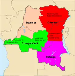
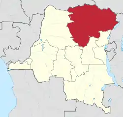
The province lay in the northeast of the country. Originally it bordered Équateur to the west, Congo-Kasaï to the southwest and Katanga to the south. After being reduced in size, it bordered Équateur to the west, Kasaï-Oriental province to the southwest, Maniema to the south, and North Kivu to the southeast. It also bordered the Central African Republic and South Sudan to the north, and Uganda to the east. The provincial capital was Stanleyville, later renamed Kisangani.
History
On 15 July 1898 the Stanley Falls District became the District of Orientale Province (District de la province Orientale), with Stanleyville as its headquarters.[1] The Lualaba District in the south was split off at this time. The district was also called Stanleyville District. In 1910 the new vice-government general of Katanga was formed the south, with parts of Lualaba District and parts of Stanleyville.[2]
Orientale/Oost Province was formed in 1913 in the Belgian Congo from the District of Orientale Province, expanded to include Haut-Uélé, Bas-Uélé and Aruwimi. The new province contained the districts of Bas-Uele, Haut-Uele, Ituri, Stanleyville, Aruwimi, Maniema, Lowa and Kivu. It was divided in 1933 into Costermansville (later Kivu) and Stanleyville Province. Stanleyville Province was renamed Orientale/Oost Province from 1947 to 1963, when it was broken up into Kibali-Ituri, Uélé and Haut-Congo provinces. Orientale Province was reconstituted in 1966 from the amalgamation of the Uele, Kibali-Ituri and Haut-Congo provinces. In 2015 it was dissolved into the provinces of Bas-Uélé, Haut-Uélé, Ituri and Tshopo.
In 1998 the Orientale villages of Durba and Watsa were the center of an outbreak of Marburg virus disease among gold mine workers.
The Ituri district of Orientale was the scene of the Ituri conflict.
As of 2014, militia groups continue to fight in the province and have reportedly committed many atrocities against the local population, such as forcing women into sex slavery and forcing men to work in mines.[3]
Approximate correspondence between historical divisions and current provinces
| Belgian Congo | Republic of the Congo | Zaire | Democratic Republic of the Congo | ||||||
|---|---|---|---|---|---|---|---|---|---|
| 1908 8 districts | 1913 1 province | 1932 1 province | 1947 1 province | 1963 3 provinces | 1966 1 province | 1971 1 province | 1988 1 province | 1997 1 province | 2015 4 provinces |
| Bas-Uele | Orientale | Stanleyville | Orientale | Uélé | Orientale | Haut-Zaïre | Orientale | Bas-Uélé | |
| Haut-Uele | Haut-Uélé | ||||||||
| Ituri | Kibali-Ituri | Ituri | |||||||
| Stanleyville | Haut-Congo | Tshopo | |||||||
| Aruwimi | |||||||||
| Maniema | (Costermansville, Kivu and successors) | ||||||||
| Lowa | |||||||||
| Kivu | |||||||||
Divisions as of 2015
See also
- List of governors of Orientale Province
- Kisangani history and timeline
References
- Auzias & Labourdette 2006, p. 180.
- Lemarchand 1964, pp. 62–63.
- Sexual slavery rife in the Democratic Republic of the Congo
- "Haut-Congo: largest cities and towns and statistics of their population". World Gazetteer. Archived from the original on 2013-02-10.
Bibliography
- Auzias, Dominique; Labourdette, Jean-Paul (2006). Congo: république démocratique. Petit Futé. ISBN 2-7469-1412-3.
- Gwillim Law (1999). "Democratic Republic of the Congo". Administrative Subdivisions of Countries: A Comprehensive World Reference, 1900 through 1998. US: McFarland & Company. pp. 92–94. ISBN 0786407298.
- Lemarchand, René (1964), Political Awakening in the Belgian Congo, University of California Press, GGKEY:TQ2J84FWCXN, retrieved 19 August 2020
External links
- Site of the province (Gouverneur and province assembly), in French
- Bamanisajean.unblog.fr is Governor Jean Bamanisa's blog site.
- Stanleyville.be City of Kisangani Website.
- @Prov_orientale Twitter for Orentale Provincial Government
- Facebook Orentale Provincial Government
- CDC "Map of the Democratic Republic of the Congo indicating the neighboring villages of Durba and Watsa, the epicenter of the 1998 outbreak of Marburg hemorrhagic fever."
- "Liste des gouverneurs de la Province Orientale". Stanleyville.be (in French). Jean-Luc Ernst. (1913-1960); +1960-2015