Ortler Alps
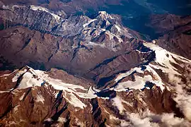
The Ortler Alps (Italian: Ortles-Cevedale [ˌɔrtlestʃeveˈdaːle]; German: Ortler-Alpen; Romansh: Alps da l'Ortler[1]) are a mountain range of the Southern Limestone Alps mountain group in the Central Eastern Alps, in Italy and Switzerland.
| Ortler Alps | |
|---|---|
| Italian: Gruppo dell'Ortles-Cevedale German: Ortler-Alpen Romansh: Alps da l'Ortler | |
 Highest peaks of the Ortler Alps | |
| Highest point | |
| Peak | Ortler |
| Elevation | 3,905 m (12,812 ft) |
| Coordinates | 46°30′32″N 10°32′42″E |
| Geography | |
| |
| Countries | Italy and Switzerland |
| Range coordinates | 46°27′N 10°37′E |
| Parent range | Southern Limestone Alps |
| Borders on | Sesvenna Alps, Livigno Alps and Adamello-Presanella Alps |
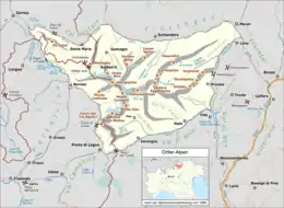
Geography
The Ortler Alps are separated from:
- the Sesvenna Alps in the north by the Ofen Pass and the Val Müstair
- the Livigno Alps in the southwest by the Passo di Fraéle and the Adda valley (Valtellina)
- the Adamello-Presanella Alps in the south by the Tonale Pass
- the Ötztal Alps in the north-east by the upper Adige valley (Vinschgau).
The part west of the Gavia Pass is also called Sobretta-Gavia Group.
The Ortler Alps are drained by the rivers Adda, Oglio, Adige and its tributary Noce.
Peaks
The main peaks of the Ortler Alps are:
| Peak (Italian) | (German) | (Romansh) | metres | feet |
|---|---|---|---|---|
| Ortles | Ortler | 3,905 | 12,811 | |
| Gran Zebrù | Königspitze | 3,857 | 12,655 | |
| Monte Cevedale | Zufallspitze | 3,774 | 12,382 | |
| Monte Zebrù | 3,735 | 12,254 | ||
| Palón della Mare | 3,705 | 12,156 | ||
| Punta San Matteo | 3,692 | 12,113 | ||
| Monte Vioz | 3,645 | 11,959 | ||
| Punta Thurwieser | Thurwieserspitze | 3,641 | 11,946 | |
| Pizzo Tresero | 3,602 | 11,818 | ||
| Cima Vertana | Vertainspitze | 3,541 | 11,618 | |
| Punta dello Scudo | Schildspitze | 3,461 | 11,355 | |
| Punta delle Bàite | Tuckettspitze | 3,458 | 11,346 | |
| Cima Sternai | Hintere Eggenspitze | 3,443 | 11,296 | |
| Gioveretto | Zufrittspitze | 3,439 | 11,283 | |
| Cima Venezia | Veneziaspitze | 3,384 | 11,103 | |
| Croda di Cengles | Tschenglser Hochwand | 3,378 | 11,083 | |
| Monte Confinale | 3,370 | 11,057 | ||
| Corno dei Tre Signori | 3,360 | 11,024 | ||
| Punta Beltovo di Dentro | Hintere Schöntaufspitze | 3,325 | 10,909 | |
| Monte Sobretta | 3,296 | 10,814 | ||
| Orecchia di Lepre | Hasenöhrl | 3,257 | 10,686 | |
| Monte Gavia | 3,223 | 10,574 | ||
| Cima la Casina | Piz Murtaröl | 3,180 | 10,430 | |
| Monte Cornaccia | Piz Tea Fondada | 3,144 | 10,315 | |
| Piz Schumbraida | 3,125 | 10,253 | ||
| Piz Umbrail | 3,033 | 9,951 | ||
| Punta Rosa | Rötlspitz | Piz Cotschen | 3,026 | 9,928 |
| Furkelsptiz | Piz Costainas | 3,004 | 9,856 | |
| Schafberg | Piz Daint | 2,968 | 9,738 | |
| Piz Turettas | 2,963 | 9,721 | ||
| Piz Dora | 2,951 | 9,682 | ||
| Schafberg | Piz Minschuns | 2,934 | 9,626 | |
| Monte Forcola | 2,906 | 9,534 | ||
| Piz Lad | 2,882 | 9,455 | ||
| Cima Garibaldi | Dreisprachenspitze | Piz da las Trais Linguas | 2,843 | 9,327 |
| Monte Cavallaccio | Piz Chavalatsch | 2,763 | 9,065 | |
| Cima del Serraglio | 2,685 | 8,809 | ||
| Munt Buffalora | 2,630 | 8,630 | ||
| Munt la Schera | 2,587 | 8,488 | ||
| Monte Padrio | 2,153 | 7,064 |
Mountain passes
The main mountain passes of the Ortler Alps are:
| Mountain pass | location | type | elevation | |
|---|---|---|---|---|
| m | ft | |||
| Hochjoch | Sulden to the Zebrù valley | snow | 3536 | 11,602 |
| Vioz Pass | Santa Caterina Valfurva to Peio | snow | 3337 | 10,949 |
| Königsjoch | Sulden to Santa Caterina | snow | 3295 | 10,811 |
| Cevedale Pass | Santa Caterina to Martell | snow | 3271 | 10,732 |
| Eissee Pass | Sulden to Martell | snow | 3133 | 10,279 |
| Passo del Zebru | Santa Caterina to the Zebrù valley | snow | 3025 | 9925 |
| Sallentjoch | Martell to Bagni di Rabbi | snow | 3021 | 9913 |
| Sforzellina Pass | Santa Caterina to Peio | snow | 3005 | 9859 |
| Tabarettascharte | Sulden to Trafoi | footpath | 2883 | 9459 |
| Stelvio Pass/Stilfserjoch | Trafoi to Bormio | road | 2760 | 9055 |
| Gavia Pass | Santa Caterina to Ponte di Legno | road | 2637 | 8651 |
| Umbrail Pass | Val Müstair to Bormio | road | 2501 | 8205 |
| Giufplan Pass | Ofen road to Val Fraéle | footpath | 2354 | 7723 |
| Dossradond Pass | Val Müstair to Val Fraéle | footpath | 2240 | 7349 |
| Ofen Pass | Zernez to Val Müstair | road | 2149 | 7051 |
| Vigiljoch | Lana | snow | 1743 | 5718 |
History
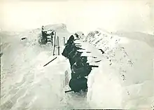
The Ortler Alps were part of the Italian front during World War I. In this area, the Austro-Hungarians and the Italians dug in during a trench war fought at altitudes above 3,000 m (10,000 ft) for most of the war. Some trenches are still visible today, and war relics continue to be found in the area.
References
- "Il salvament aviatic sur ils cunfins or vegn simplifitgà". gr.ch (in Romansh). Canton of Grisons. 1998-04-14. Retrieved 2020-09-16.
da l'Ortler
External links
 Media related to Ortler Alps at Wikimedia Commons
Mountain ranges of the Southern Limestone Alps according to the AVE | ||
|---|---|---|