Nonsberg Group
The Nonsberg Group (German: Nonsberggruppe, Italian: Alpi della Val di Non) is a mountain range in South Tyrol and Trentino in Italy and part of the Southern Limestone Alps. A large part of the Nonsberg Group is formed by the Mendelkamm. Their highest peak is the Laugenspitze (2,434 m s.l.m.). The Nonsberg Group is bounded in the east by the Etschtal, to the north by the Prissian High Forest (Ger: Prissianer Hochwald, It: Selva di Prissiano) on the Gampen Pass (It: Passo delle Palade) and in the west by the Non Valley (Ger: Nonstal, It: Val di Non).
| Nonsberg Group | |
|---|---|
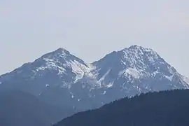 The twin peaks of the Laugenspitze | |
| Highest point | |
| Peak | Laugenspitze |
| Elevation | 2,434 m s.l.m. |
| Geography | |
 Location of the Nonsberg Group within the Eastern Alps | |
| State | South Tyrol and Trentino, Italy |
| Range coordinates | 46°32′05″N 11°05′09″E |
| Parent range | Eastern Alps |
Location
The boundary of the range according to the Alpine Club Classification of the Eastern Alps (AVE):[1]
- Merano – Etschtal to Mezzocorona − Noce Valley (lower Non Valley/Val di Sole) – Lago di Santa Giustina – Val di Pescara – Proveis − Lederbuch – Hofmahd – Maraunbach to its confluence with the Valschauer Bach – Ultental – Lana – Merano
Until its reclassification in AVE 1984 this group was counted as part of the Brenta Group according to the old 1924 Moriggl Classification (ME).
Important summits
From north to south:
- Laugenspitze (Monte Lucco, 2,434 m s.l.m.)
- Hofbichl (Monte Salomp, 1,818 m s.l.m.)
- Gantkofel (Monte Macaion, 1,866 m s.l.m.)
- Penegal (1,737 m s.l.m.)
- Roen (Monte Roen, 2,116 m s.l.m.)
- Schönleiten (Coste Belle, 1,811 m s.l.m.)
- Tresner Horn (Corno di Tres, 1,817 m s.l.m.)
- Monticello (1,857 m s.l.m.)
References
External links
| Wikimedia Commons has media related to Nonsberg group. |
Mountain ranges of the Southern Limestone Alps according to the AVE | ||
|---|---|---|