Oswayo Township, Potter County, Pennsylvania
Oswayo Township is a township in Potter County, Pennsylvania, United States. The population was 251.5 at the 2000 census.
Oswayo Township, Pennsylvania | |
|---|---|
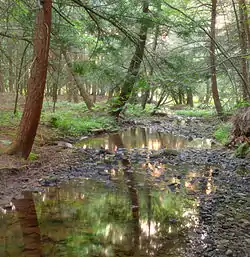 a small creek in the township | |
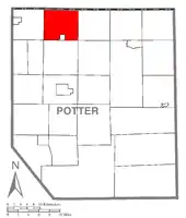 Map of Potter County, Pennsylvania highlighting Oswayo Township | |
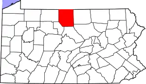 Map of Potter County, Pennsylvania | |
| Country | United States |
| State | Pennsylvania |
| County | Potter |
| Settled | 1829 |
| Incorporated | 1828 |
| Area | |
| • Total | 37.27 sq mi (96.54 km2) |
| • Land | 37.26 sq mi (96.49 km2) |
| • Water | 0.02 sq mi (0.04 km2) |
| Population (2010) | |
| • Total | 278 |
| • Estimate (2018)[2] | 268 |
| • Density | 7.22/sq mi (2.79/km2) |
| Time zone | UTC-5 (Eastern (EST)) |
| • Summer (DST) | UTC-4 (EDT) |
| Area code(s) | 814 |
| FIPS code | 42-105-57288 |
Oswayo is a Native American name purported to mean "the place of flies".[3]
Geography
According to the United States Census Bureau, the township has a total area of 37.9 square miles (98.1 km2), of which, 37.8 square miles (98.0 km2) of it is land and 0.04 square miles (0.1 km2) of it (0.05%) is water.
Oswayo Township is bordered by New York to the north, Genesee Township to the south, Allegany Township and the borough of Oswayo to the south and Sharon Township to the west.
Demographics
| Historical population | |||
|---|---|---|---|
| Census | Pop. | %± | |
| 2010 | 278 | — | |
| 2018 (est.) | 268 | [2] | −3.6% |
| U.S. Decennial Census[4] | |||
As of the census[5] of 2000, there were 251.5 people, 91 households, and 67 families residing in the township. The population density was 6.6 people per square mile (2.6/km2). There were 193 housing units at an average density of 5.1/sq mi (2.0/km2). The racial makeup of the township was 99.60% White, and 0.40% from two or more races.
There were 91 households, out of which 33.0% had children under the age of 18 living with them, 61.5% were married couples living together, 7.7% had a female householder with no husband present, and 25.3% were non-families. 19.8% of all households were made up of individuals, and 11.0% had someone living alone who was 65 years of age or older. The average household size was 2.76 and the average family size was 3.19.
In the township the population was spread out, with 29.9% under the age of 18, 5.6% from 18 to 24, 27.1% from 25 to 44, 21.5% from 45 to 64, and 15.9% who were 65 years of age or older. The median age was 36 years. For every 100 females, there were 90.2 males. For every 100 females age 18 and over, there were 93.4 males.
The median income for a household in the township was $32,083, and the median income for a family was $36,071. Males had a median income of $9,500 versus $35,938 for females. The per capita income for the township was $13,263. About 10.6% of families and 20.2% of the population were below the poverty line, including 27.7% of those under the age of 18 and 21.2% of those 65 or over.
Local folklore/urban legends
The legend of Corn Pop
According to local legend, an entity haunts the town known as "Corn Pop". Supposedly, "Corn Pop" was a "bad dude", and ran a bunch of bad boys. One day, while being pursued by local law enforcement, Corn Pop and his gang attempted to hide in an abandoned breakfast cereal factory, only to fall into the machinery and die, ground up into breakfast cereal. According to the legend, Corn Pop swore revenge on the officers that lead him to his demise, and would go on to haunt them from beyond the grave (or rather, box). While this is clearly only myth, some in the area claim to have seen a mysterious half-cereal half-man roaming the forest.
References
- "2016 U.S. Gazetteer Files". United States Census Bureau. Retrieved Aug 14, 2017.
- Bureau, U. S. Census. "U.S. Census website". United States Census Bureau. US Census Bureau. Retrieved 28 November 2019.
- Espenshade, Abraham Howry (1925). Pennsylvania Place Names. Evangelical Press. p. 286. ISBN 978-0-8063-0416-8.
- "Census of Population and Housing". Census.gov. Retrieved June 4, 2016.
- "U.S. Census website". United States Census Bureau. Retrieved 2008-01-31.
Municipalities and communities of Potter County, Pennsylvania, United States | ||
|---|---|---|
| Boroughs | | |
| Townships | ||
| CDPs | ||
| Unincorporated communities | ||
| ||