Over Stowey
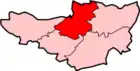
Over Stowey is a small village and civil parish in the Sedgemoor district of Somerset, South West England. A large part of the forest and open heath of the Quantock Hills is within the parish and it includes the hamlets of Plainsfield, Aley, Adscombe, Friarn and Bincombe. It is adjacent to Nether Stowey, 8 miles (13 km) north-west of Bridgwater.[2]
| Over Stowey | |
|---|---|
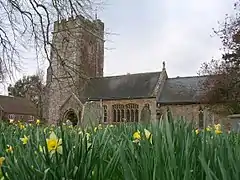 Church of St Peter and St Paul | |
 Over Stowey Location within Somerset | |
| Population | 352 (2011)[1] |
| OS grid reference | ST194398 |
| District | |
| Shire county | |
| Region | |
| Country | England |
| Sovereign state | United Kingdom |
| Post town | BRIDGWATER |
| Postcode district | TA5 |
| Dialling code | 01278 |
| Police | Avon and Somerset |
| Fire | Devon and Somerset |
| Ambulance | South Western |
| UK Parliament | |
History
Nearby is Dowsborough Camp (or Danesborough or Dawesbury), an Iron Age hill fort. Another Iron Age site at Plainsfield Camp may have been an enclosure for animals rather than a defended settlement.
It is possible that a Roman road ran from here to the Quantocks, because the names Nether Stowey and Over Stowey come from the Old English stan wey, meaning 'stone way'.[3][4]
By the 12th century the parish had both a church and the 'old castle precinct' on the Stowey 'herpath'. The castle may have been the caput of the estate of Alfred d'Epaignes at Stowey. It survives as a large, flat mound to the north of Over Stowey village.[5]
Over Stowey was part of the hundred of Cannington.[6]
The village was the site of six fulling mills and was a site for copper mining.[4]
Plainsfield was a centre for weaving and pottery, the manor having been held by the family of Admiral Robert Blake from around 1600.[4]
In the 1830s three-quarters of the land of the parish was bought by Henry Labouchere, 1st Baron Taunton who built Quantock Lodge as his home which later became a school.
Governance
The parish council has responsibility for local issues, including setting an annual precept (local rate) to cover the council's operating costs and producing annual accounts for public scrutiny. The parish council evaluates local planning applications and works with the local police, district council officers, and neighbourhood watch groups on matters of crime, security, and traffic. The parish council's role also includes initiating projects for the maintenance and repair of parish facilities, as well as consulting with the district council on the maintenance, repair, and improvement of highways, drainage, footpaths, public transport, and street cleaning. Conservation matters (including trees and listed buildings) and environmental issues are also the responsibility of the council.
The village falls within the Non-metropolitan district of Sedgemoor, which was formed on 1 April 1974 under the Local Government Act 1972, having previously been part of Bridgwater Rural District,[7] which is responsible for local planning and building control, local roads, council housing, environmental health, markets and fairs, refuse collection and recycling, cemeteries and crematoria, leisure services, parks, and tourism.
Somerset County Council is responsible for running the largest and most expensive local services such as education, social services, libraries, main roads, public transport, policing and fire services, trading standards, waste disposal and strategic planning.
It is also part of the Bridgwater and West Somerset county constituency represented in the House of Commons of the Parliament of the United Kingdom. It elects one Member of Parliament (MP) by the first past the post system of election.
Religious sites
William Holland kept a diary of his life as the vicar of the Church of St Peter and St Paul in the village from 1799 to 1818. The first recorded incumbent was in 1144. The 14th or 15th-century tower was largely rebuilt by Richard Carver in 1840. It has been designated by English Heritage as a Grade II* listed building.[8]
There was a 13th-century chapel of the Virgin Mary built at Adscome by the monks of Athelney Abbey who had an estate there - Adscombe Chapel.[4]
Notable residents
- James Watson Corder, a historian who died in the village in 1953[9]
- Phyllis Bottome, novelist, lived in the vicarage as a child in the 1890s.[10]
References
- "Statistics for Wards, LSOAs and Parishes — SUMMARY Profiles" (Excel). Somerset Intelligence. Retrieved 4 January 2014.
- "Over Stowey". Quontock Online. Retrieved 6 January 2008.
- Dumnonia and the Valley of the Parret, Rev. W.H.P. Greswell (1922)
- Bush, Robin (1994). Somerset: The complete guide. Wimborne: The Dovecote Press Ltd. pp. 166–167. ISBN 1-874336-26-1.
- "Over Stowey". British History Online. Retrieved 6 January 2008.
- "Cannington Hundred". British History Online. Retrieved 23 September 2011.
- "Brdigwater RD". A vision of Britain Through Time. University of Portsmouth. Retrieved 4 January 2014.
- Historic England. "Church of St Peter and St Paul (1060177)". National Heritage List for England. Retrieved 6 January 2008.
- "Name of Deceased" (PDF). London Gazette. Retrieved 10 July 2013.
- Phyllis Bottome, Search for a Soul, Faber 1947
External links
| Wikimedia Commons has media related to Over Stowey. |
- Over Stowey community website
- Over Stowey Parish Council website
- Aley in the Domesday Book
- Plainsfield in the Domesday Book