Owens River course
The Owens River course includes headwaters points near the Upper San Joaquin Watershed,[2] reservoirs and diversion points (e.g., for the Los Angeles Aqueduct), and the river's mouth at Owens Lake. The river drains the Crowley Lake Watershed (USGS HUC 18090102) of 1,900 sq mi (4,900 km2) and the north portion of the Owens Lake Watershed (USGS HUC 18090103) of 1,340 sq mi (3,500 km2).[2]
| wikiarticle for point | description of point | elevation & coordinates |
|---|---|---|
| Sierra Crest | headwaters (San Joaquin Mountain summit)[1]:113 | 11,555 ft (3,522 m)37°43′09″N 119°6′21″W |
| Deadman Creek | watercourse originates (perennial flow east of summit) | 10,794 ft (3,290 m)[3]37°43′12″N 119°5′58″W |
| Sierra Escarpment | watercourse exits the Sierra Nevada | |
| Glass Creek | confluence[1]:111 | |
| lower montane forest | exits upper montane forest into pinyon/juniper-dominated area | 9,000 ft (2,700 m) |
| Big Springs | confluence (river designation) | 7,248 ft (2,209 m)[3]37°45′01″N 118°56′20″W |
| Long Valley | enters valley | |
| Basin & Range ecoregion | enters bitterbrush/sagebrush-dominated area[1]:26 | 7,000 ft (2,100 m) |
| Long Valley Caldera | enters volcanic region of Walker Lane | |
| stream gauge prior to tunnel 76 cu ft/s (2.2 m3/s), 350/150 spring/winter[1]:67,108 | ||
| -16 cu ft/s (0.45 m3/s) outflow into Mono Craters tunnel (1941-1989 inflow)[1]:67,70 | [1]:108 ... | |
| exits Inyo National Forest | ||
| exits Inaja Ranch[1]:89 | [1]:89 ... | |
| confluence, Hot Creek[1]:47 | ||
| Benton Crossing[1]:89 | [1]:89 ... | |
| Crowley Lake | enters reservoir | [1]:89 ... |
| confluence, Convict Creek (west side) | ||
| confluence, Hilton Creek (south side) | ||
| inflow of water diverted from Rock Creek[1] | ||
| confluence, Whiskey Creek (south) | ||
| confluence, Crooked Creek (south)[4] | ||
| -16 cu ft/s (0.45 m3/s)[5] diversion (hydroelectric pipeline to Pleasant V Reservoir)[6] | ||
| Long Valley Dam (exits caldera & 380 sq mi (980 km2) Long Hydrologic Unit)[1] | 6,783 ft (2,067 m)[3]37°35′17″N 118°42′25″W | |
| Owens River Gorge | stream gauge at main weir (downstream of dam)[1]:74 | |
| re-enters Inyo National Forest | 37°35′21″N 118°41′58″W | |
| exits Mono County, enters Inyo County[7] | ||
| exits Inyo National Forest | 37°35′17″N 118°42′25″W | |
| confluence, Lower Rock Creek | ||
| enters Pleasant Valley Reservoir | ||
| reservoir dam (Middle Owens River begins)[4]:T-2 | 37°24′53″N 118°31′28″W | |
| enters valley at exit of gorge[8] | ||
| Round Valley[7] | ||
| Horton Creek | confluence | |
| Owens Valley | exits Round Valley,[8]:4 enters Owens Valley | |
| Spring Valley Wash | confluence | |
| McNally canals | diversion for irrigation[4] | |
| Fish Slough | confluence | |
| US 6 | bridge | |
| Laws Ditch | inflow north of Bishop, California[4] | |
| Bishop Creek | confluence | |
| Big Pine canal | diversion[4] | |
| Fish Springs canal | diversion[4] | |
| A-drain | inflow[4] | |
| Big Pine Creek | confluence | 3,916 ft (1,194 m)[3]37°10′22″N 118°15′34″W |
| Tinemaha Reservoir | gauge station at inflow | |
| confluence, Tinemaha Creek (west side) | ||
| outlet at dam | ||
| Owens Lake Watershed | exits Crowley Lake Watershed | |
| LA Aqueduct | 325-foot (99 m) diversion weir (Lower Owens River begins)[4]:T-2 | 36°58′32″N 118°12′38″W |
| SR 136 | stream gauge & pumpback station at Keeler Bridge | 36°34′28″N 118°0′40″W |
| Owens Lake | mouth | 3,556 ft (1,084 m)36°26′0″N 117°57′3″W |
| External images | |
|---|---|
| Owens River | |
|---|---|
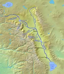 The Owens River course begins (top left) as Deadman Creek, and the river designation begins where the Big Springs tributary enters the Deadman Creek channel.[1]:89,108,113 | |
| Location | |
| Country | United States |
| State | California |
| Physical characteristics | |
| Length | 120 mi (190 km), north-south |
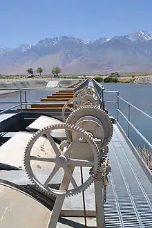
Diversion gates that control inflow to the Lower Owens River
References
- "Upper Owens River Basin" (PDF). Planning Division: Mono County Community Development Department. March 2007. Archived from the original (pdf) on 2010-06-19. Retrieved 2010-06-15.
- "Boundary Descriptions and Names of Regions, Subregions, Accounting Units and Cataloging Units". USGS.gov. Retrieved 2010-06-07.
- "USGS Elevation Web Service Query". United States Geological Survey. Archived from the original on 2010-05-27. Retrieved 2010-02-19. Specific queries:
- Deadman source: Query of 37.719914, -119.09935 returns 10794 ft
- Deadman confluence: Query of 37.750278, -118.938889 returns 7247.6 ft
- Long Valley Dam: "Query of Google Map coordinates [X_Value=-118.706846&Y_Value=37.587949] returns 6783 ft". Retrieved 2010-06-12.
- Big Pine confluence: Query of 37.172778, -118.259444 returns 3916.18 ft
- "Appendix T. Hydrologic Characteristics of the Owens River Basin below the Upper Owens River" (PDF). MonoBasinResearch.org. Retrieved 2010-06-14.
The Middle Owens River is the segment between Pleasant Valley Reservoir and the Los Angeles Aqueduct (LA Aqueduct) intake downstream of Tinemaha Reservoir.
- Kenny, Joe (July 2000). "Owens Gorge Rewatering Project". Executive Officer's Report. Retrieved 2010-07-13.
- "Owens River and the Los Angeles Aqueduct". Evaluation of the Hydrologic System and Selected Water-Management Alternatives in the Owens Valley, California. Retrieved 2010-07-13.
a 96- to 108-inch pipeline (penstock) that connects Lake Crowley in the Long Valley with the Pleasant Valley Reservoir
- "Owens River–Los Angeles Aqueduct system..." (pdf). Evaluation of the Hydrologic System and Selected Water-Management Alternatives in the Owens Valley, California. Retrieved 2010-07-13. External link in
|work=(help) - Wilerson, Gregg; et al. (2007). "Roadside Geology and Mining History: Owens Valley and Mono Basin" (PDF). p. 40. Archived from the original (pdf) on June 14, 2011. Retrieved 2010-06-14.
On December 6, 2006 the LA Department of Water and Power was ordered to divert 5% of the annual flow of the Owens River out of the aqueduct and back into Owens Gorge to support the trout fishery.
| Wikimedia Commons has media related to Owens River. |
This article is issued from Wikipedia. The text is licensed under Creative Commons - Attribution - Sharealike. Additional terms may apply for the media files.