Los Angeles Aqueduct
The Los Angeles Aqueduct system, comprising the Los Angeles Aqueduct (Owens Valley aqueduct) and the Second Los Angeles Aqueduct, is a water conveyance system, built and operated by the Los Angeles Department of Water and Power.[6] The Owens Valley aqueduct was designed and built by the city's water department, at the time named The Bureau of Los Angeles Aqueduct, under the supervision of the department's Chief Engineer William Mulholland.[7] The system delivers water from the Owens River in the Eastern Sierra Nevada Mountains to Los Angeles, California.
Los Angeles Aqueduct | |
|---|---|
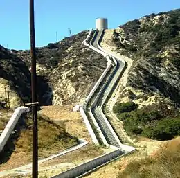 The Second Los Angeles Aqueduct Cascades, Sylmar | |
| Coordinates | 36°58′32″N 118°12′37″W |
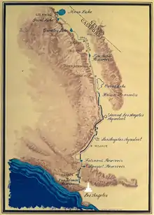
| Begins | First Aqueduct Owens River, Inyo County 36.975678°N 118.210541°W Second Aqueduct Haiwee Reservoir, Inyo County 36.182600°N 117.958470°W Mono Extension Upper Lee Vining Creek, Mono County 37.936151°N 119.134426°W |
| Ends | First & Second Aqueduct Upper Van Norman Lake (Los Angeles Reservoir), Granada Hills, Los Angeles 34.312860°N 118.492988°W Mono Extension Owens River, Mono County 37.756910°N 118.890911°W |
| Official name | Los Angeles Aqueduct Second Los Angeles Aqueduct Mono Extension |
| Maintained by | Los Angeles Department of Water and Power |
| Characteristics | |
| Total length | 419 mi (674 km) |
| Diameter | 12 ft (3.7 m) |
| First section length | 233 mi (375 km) |
| Second section length | 137 mi (220 km) |
| Capacity | First Aqueduct 422 cu ft/s (11.9 m3/s) Second Aqueduct 290 cu ft/s (8.2 m3/s) |
| History | |
| Construction start | First Aqueduct October 1908 Second Aqueduct September 1965 |
| Opened | First Aqueduct November 1913 Second Aqueduct June 1970 |
| Location | |

| |
| References | |
| [1][2][3][4][5] | |
Known as the California water wars, its construction was controversial from the start, as water diversions to Los Angeles eliminated the Owens Valley as a viable farming community.[8] The continued operation has led to public debate, legislation, and court battles over the environmental impacts of the aqueduct on Mono Lake and other ecosystems.
Construction
The aqueduct project began in 1905 when the voters of Los Angeles approved a US$1.5 million bond for the 'purchase of lands and water and the inauguration of work on the aqueduct'. On June 12, 1907 a second bond was passed with a budget of US$24.5 million to fund construction.[9][10]
Construction began in 1908 and was divided into eleven divisions and a cement plant. The number of men who were on the payroll the first year was 2,629 and this number peaked at 6,060 in May 1909. In 1910, employment dropped to 1,150 due to financial reasons but rebounded later in the year. Between 1911 and 1912 employment ranged from 2,800 to 3,800 workers. The number of laborers working on the aqueduct at its peak was 3,900.[11][12][13][14] In 1913, the City of Los Angeles completed construction of the first Los Angeles Aqueduct.
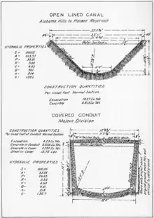
The aqueduct as originally constructed consisted of six storage reservoirs and 215 mi (346 km) of conduit. Beginning 3.5 mi (5.6 km) north of Black Rock Springs, the aqueduct diverts the Owens River into an unlined canal to begin its 233 mi (375 km) journey south to the Lower San Fernando Reservoir.[15] This reservoir was later renamed the Lower Van Norman Reservoir.
The original project consisted of 24 mi (39 km) of open unlined canal, 37 mi (60 km) of lined open canal, 97 mi (156 km) of covered concrete conduit, 43 mi (69 km) of concrete tunnels, 12.00 mi (19.31 km) steel siphons, 120 mi (190 km) of railroad track, two hydroelectric plants, three cement plants, 170 mi (270 km) of power lines, 240 mi (390 km) of telephone line, 500 mi (800 km) of roads[16] and was later expanded with the construction of the Mono Extension and the Second Los Angeles Aqueduct.[17]
The aqueduct uses gravity alone to move the water and also uses the water to generate electricity, which makes it cost-efficient to operate.[18] The aqueduct system has been operated safely throughout its history and is still in operation.
Controversy
The construction of the Los Angeles Aqueduct effectively eliminated the Owens Valley as a viable farming community and eventually devastated the Owens Lake ecosystem.[19] A group labeled the "San Fernando Syndicate" – including Fred Eaton, Mulholland, Harrison Otis (the publisher of The Los Angeles Times), Henry Huntington (an executive of the Pacific Electric Railroad), and other wealthy individuals – were a group of investors who bought land in the San Fernando Valley allegedly based on inside knowledge that the Los Angeles aqueduct would soon irrigate it and encourage development.[19] Although there is disagreement over the actions of the "syndicate" as to whether they were a "diabolical" cabal or only a group that united the Los Angeles business community behind supporting the aqueduct,[20][21] Eaton, Mulholland and others connected with the project have long been accused of using deceptive tactics and underhanded methods to obtain water rights and block the Bureau of Reclamation from building water infrastructure for the residents in Owens Valley.[22] By the 1920s, the aggressive pursuits of the water rights and the diversion of the Owens River precipitated the outbreak of violence. Farmers in Owens Valley attacked infrastructure, dynamiting the aqueduct numerous times and opening sluice gates to divert the flow of water.
Mono Basin Extension
In an effort to find more water, the city of Los Angeles reached farther north. In 1930, Los Angeles voters passed a third US$38.8 million bond to buy land in the Mono Basin and fund the Mono Basin extension.[23] The 105 mi (169 km) extension diverted flows from the Rush Creek, Lee Vining Creek, Walker and Parker Creeks that would have flowed into Mono Lake. The construction of the Mono extension consisted of an intake at Lee Vining Creek, the Lee Vining conduit to the Grant Reservoir on Rush Creek, which would have a capacity of 48,000 acre⋅ft (59,000,000 m3), the 12.7 mi (20.4 km) Mono Craters Tunnel to the Owens River and a second reservoir, later named Crowley Lake with a capacity of 183,465 acre⋅ft (226,301,000 m3) in Long Valley at the head of the Owens River Gorge.[24]
Completed in 1940, diversions began in 1941. The Mono Extension has a design capacity of 400 cu ft/s (11,000 L/s) of flow to the aqueduct;[25] however, the flow was limited to 123 cu ft/s (3,500 L/s) due to the limited downstream capacity of the Los Angeles Aqueduct. Full appropriation of the water could not be met until the second aqueduct was completed in 1970.[24]
The Mono Extension's impact on Mono Basin and litigation
Between 1940 and 1970, water exports through the Mono Extension averaged 57,067 acre feet (70 million cubic meters) per year and peaked at 135,000 acre⋅ft (167 million m3) in 1974. Export licenses granted by the State Water Resources Control Board (SWRCB) in 1974 increased exports to 167,000 acre⋅ft (206 million m3) per year.[24] These export levels severely impacted the region's fish habitat, lake level and air quality, which led to a series of lawsuits.[26] The results of the litigation culminated with a SWRCB Decision to restore fishery protection (stream) flows to specified minimums, and raise Mono Lake to 6,391 feet (1,948 m) above sea level. The agreement limited further exports from the Mono Basin to 10,000 acre⋅ft (12.3 million m3) per year.[27]
Second Los Angeles Aqueduct
In 1956, the State Department of Water Resources reported that Los Angeles was only exporting 320,000 acre feet (390 million cubic metres) of water of the 590,000 acre⋅ft (730 million m3) available in the Owens Valley and Mono Basin. Three years later, the State Water Rights Board warned Los Angeles that they could lose rights to the water they were permitted for but not appropriating.
Faced with the possible loss of future water supply, Los Angeles began the five-year construction of the aqueduct in 1965 at a cost US$89 million.[5] Once the city received diversion permits, water exports jumped in 1970, adding 110,000 AF that year into the aqueduct system. By 1974, exports climbed to 450,000 acre⋅ft (560 million m3) per year.[24]
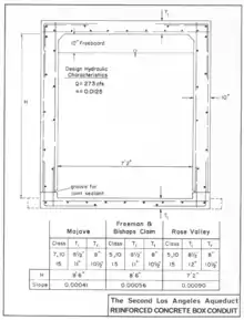
The 137-mile-long (220 km) aqueduct was designed to flow 290 cu ft/s (8,200 L/s) and begins at the Merritt Diversion Structure at the junction of the North and South Haiwee Reservoirs,[4] south of Owens Lake, and runs roughly parallel to the first aqueduct. Water flows entirely by gravity from an elevation of 3,760 feet (1,150 m) at the Haiwee Reservoir through two power drops to an elevation of 1,200 ft (370 m) at the Upper Van Norman Reservoir.[28]
The Second Aqueduct was not built as a single contiguous conduit. For design and construction purposes the aqueduct was divided into Northern and Southern sections and the two are connected by the San Francisquito Tunnels, which are part of the First Aqueduct.
The Northern Section carries water starting at the North Haiwee Reservoir through the Haiwee Bypass passing around the South Haiwee Reservoir. The flow then continues 115 miles (185 km) south through a series of pressure pipelines and concrete conduits where it connects up with the First Aqueduct at the North Portal of the Elizabeth Tunnel near the Fairmont Reservoir.[29]
The San Francisquito Tunnels (which includes the Elizabeth Tunnel) has a flow capacity of 1,000 cu ft/s (28,000 L/s)[29] and is large enough to handle the flow of both aqueducts. Once the combined flow reaches the penstocks above Power Plant #2, water is diverted into the Southern Section of the second aqueduct away through the Drinkwater Tunnel to the Drinkwater Reservoir.
The last segment of pipe, known as the Saugus Pipeline,[30] carries water south past Bouquet Canyon, Soledad Canyon and Placerita Canyon. From there it roughly parallels Sierra Highway before it enters Magazine Canyon towards the Terminal structure and Cascades. Water from the Terminal structure can then flow to either the Cascade or penstock to the Foothill Power Plant and into the Upper Van Norman Reservoir.
In addition to the construction in the Northern and Southern sections, improvements were also made to the lined canal between the Alabama Gates and the North Haiwee Reservoir in the Northern Section that consisted of adding 24 in (610 mm) sidewalls to both sides of the canal and the raising of overcrosses. This work increased the capacity of the lined canal from 710 cu ft/s (20,000 L/s) to 900 cu ft/s (25,000 L/s) cfs.[31]
The second aqueduct's impact on the water system
The increased flows provided by the second aqueduct lasted only from 1971 through 1988.[32] In 1974 the environmental consequences of the higher exports were first being recognized in the Mono Basin and Owens Valley. This was followed by a series of court ordered restrictions imposed on water exports, which resulted in Los Angeles losing water.[24] In 2005, the Los Angeles Urban Water Management Report reported that 40–50% of the aqueduct's historical supply is now devoted to ecological resources in Mono and Inyo counties.[33][34]
Influence on Los Angeles and the county
Between 1909 and 1928, the city of Los Angeles grew from 61 square miles to 440 square miles. This was due largely to the aqueduct, and the city's charter was worded such that it stated the City of Los Angeles could not sell or provide surplus water to any area outside the city.[35][36][37] Outlying areas relied on wells and creeks for water and, as they dried up, the people in those areas realized that if they were going to be able to continue irrigating their farms and provide themselves domestic water, they would have to annex themselves to the City of Los Angeles.[35]
Growth was so rapid that it appeared as if the city of Los Angeles would eventually assume the size of the entire county. William Mulholland continued adding capacity to the aqueduct, building the St. Francis Dam that would impound the waters creating the San Francisquito Reservoir, filed for additional water on the Colorado River and he began sending engineers and miners to clear the heading at the San Jacinto Tunnel that he knew was key to the construction of the Colorado River Aqueduct.[38][39]
The aqueduct's water provided developers with the resources to quickly develop the San Fernando Valley and Los Angeles through World War II. Mulholland's role in the vision and completion of the aqueduct and the growth of Los Angeles into a large metropolis is recognized with the William Mulholland Memorial Fountain, built in 1940 at Riverside Drive and Los Feliz Boulevard in Los Feliz. Mulholland Drive and Mulholland Dam are both named after him.
Many more cities and unincorporated areas would likely have annexed into the city of Los Angeles if the St. Francis Dam had not collapsed. The catastrophic failure of the St. Francis Dam in 1928 killed an estimated 431 people,[40] flooded parts of Santa Clarita, and devastated much of the Santa Clara River Valley in Ventura County.[35][41]
The failure of the dam raised the question in a number of people's minds whether the city had engineering competence and capability to manage such a large project as the Colorado River Aqueduct despite the fact that they had built the Los Angeles Aqueduct.[35] After the collapse, the pace of annexation came to a rapid halt when eleven nearby cities including Burbank, Glendale, Pasadena, Beverly Hills, San Marino, Santa Monica, Anaheim, Colton, Santa Ana, and San Bernardino decided to form the Metropolitan Water District with Los Angeles.[42] The city's growth following the formation of the MWD would be limited to 27.65 square miles.[41][43]
California Historical Landmark – Cascades
The Cascades, which was completed on November 5, 1913, is located near the intersection of Foothill Boulevard and Balboa Boulevard, four miles northwest of San Fernando. It was designated as a California Historical Landmark on July 28, 1958.[44][45]
Gallery
 Diversion gates that control inflow to the Lower Owens River
 Intake where water is diverted from the Owens River
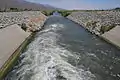 Water entering the aqueduct at its northern terminus
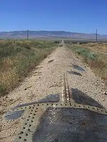 The Los Angeles Aqueduct in Antelope Valley
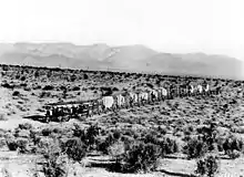 Holt tractors at work during construction of the first aqueduct in 1909
 Unlined section of the Los Angeles Aqueduct, just south of Manzanar, near US Highway 395
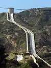 The Terminal Structure and penstock above and alongside the new Cascades on the Los Angeles Aqueduct near Newhall Pass
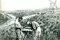 Department Surveyors plotting topography for Second Los Angeles Aqueduct.
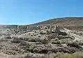 Fairmont Mill ruins on the east side of Fairmont Butte. This mill was one of three that the city ran to produce cement for the Los Angeles Aqueduct.
.jpg.webp) Chart showing water imports through the Los Angeles Aqueduct system from 1913 through 2011.
Chart showing water imports through the Los Angeles Aqueduct system from 1913 through 2011.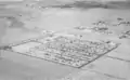 Shangri-La Estates in Ridgecrest, CA was built to provide temporary housing for personnel during the construction of the SLAA.
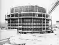 Forming in place for Terminal Structure above the SLAA cascade.
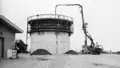 Pouring concrete for Terminal Structure above the SLAA cascade.
See also
References
Notes
- U.S. Geological Survey (19 January 1981). "Feature Detail Report: Los Angeles Aqueduct - Inyo County". Retrieved 2014-06-22.
- U.S. Geological Survey (19 January 1981). "Feature Detail Report: Los Angeles Aqueduct - Los Angeles County". Retrieved 2014-06-22.
- U.S. Geological Survey (19 January 1981). "Feature Detail Report: Los Angeles Aqueduct - Kern County". Retrieved 2014-06-22.
- The Second Los Angeles Aqueduct. The Department of Water and Power, City of Los Angeles. 1971. p. 263.
- "Los Angeles Aqueduct Facts". Los Angeles Department of Water and Power. Archived from the original on 2013-01-21. Retrieved 2012-09-14.
- "The Story of the Los Angeles Aqueduct". Los Angeles Department of Water and Power. Archived from the original on 2009-02-01. Retrieved 2009-02-07.
- "DWP - Name Change Chronology". Water and Power Associates.
- Smith, Genny; Putnam, Jeff; James, Greg; DeDecker, Mary; Heindel, Jo (1995). Deepest Valley: Guide to Owens Valley, its Roadsides and Mountain Trails. Genny Smith Books. ISBN 978-0-931378-14-0.
- Complete report on construction of the Los Angeles Aqueduct. Los Angeles Department of Public Service. 1916. OL 23386153M.p.14-17; p. 271
- Nathan Masters (4 April 2012). "Canoga Park at 100: A Brief History of the Birth of Owensmouth". KCET.
- "World Records". Los Angeles Department of Water and Power. Archived from the original on 2014-05-12. Retrieved 2014-06-13.
- Annual Report of the Bureau of the Los Angeles Aqueduct to the Board of Public Works. Los Angeles Department of Water and Power. 1908. Retrieved 2014-06-08.
- "A Hundred or a Thousand Fold More Important". Los Angeles Department of Water and Power. Archived from the original on 2009-02-23. Retrieved 2009-02-07.
- Heinly, Burt A. (July 1910). "Carrying Water Through A Desert: The Story of the Los Angeles Aqueduct". The National Geographic Magazine. XXI (7): 568–596. Retrieved 2009-07-10. Includes construction photos.
- Complete Report on the Construction of the Los Angeles Aqueduct. Los Angeles Department of Public Service. 1916. pp. 75–76.
- Complete Report on the Construction of the Los Angeles Aqueduct. Los Angeles Department of Public Service. 1916. pp. 271.
- The Second Los Angeles Aqueduct. The Department of Water and Power, City of Los Angeles. 1971. pp. xvii.
- "The Owens Valley Is the Only Source". Los Angeles Department of Water and Power. Archived from the original on 2009-02-23. Retrieved 2009-02-07.
- Piper, Karen (2006). Left in the Dust: How Race and Politics Created a Human and Environmental Tragedy in L.A.. New York: Palgrave MacMillan.
- "The Los Angeles Aqueduct and the Owens and Mono Lakes (MONO Case #379)". TED Case Studies. American University. 7 (1). January 1997. Archived from the original on 1997-04-03. Retrieved 2012-09-13.
- Kahrl, William. L. (1982). Water and Power. Los Angeles: University of California. p. 440. ISBN 0-520-05068-1.
- Davis, ML (1993). Rivers in the Desert. e-reads. ISBN 978-1-58586-137-8.
- Liebcap, Gary D (2007). Owens Valley Revisited. Stanford Economics and Finance. p. 133. ISBN 978-0-8047-5380-7.
- Liebcap, Gary D (2007). Owens Valley Revisited. Stanford Economics and Finance. pp. 135–138. ISBN 978-0-8047-5380-7.
- "Facts about the LA Aqueduct" (PDF). Mono Lake Committee. Cite journal requires
|journal=(help) - "Political and Legal Chronology". Mono Basin Clearinghouse.
- "Decision to Amend Water Right Licences". Mono Basin Clearinghouse.
- The Second Los Angeles Aqueduct. Summary: The Department of Water and Power. 1971. pp. xvii.
- The Second Los Angeles Aqueduct. The Department of Water and Power, City of Los Angeles. 1971. pp. 12–13.
- The Second Los Angeles Aqueduct. The Department of Water and Power, City of Los Angeles. 1971. pp. 83–95.Includes maps and pictures
- The Second Los Angeles Aqueduct. The Department of Water and Power, City of Los Angeles. 1971. pp. 257–260.
- "2005 Urban Water Management Report" (PDF). Los Angeles Department of Water and Power. p. 3. Retrieved 2013-10-28.
- "2005 Urban Water Management Report" (PDF). Los Angeles Department of Water and Power. p. ES-8. Retrieved 2013-10-28.
- "2010 Urban Water Management Report". Los Angeles Department of Water and Power. p. 103. Retrieved 2013-10-28.
- Basiago, Andrew D. (February 7, 1988), Water For Los Angeles – Sam Nelson Interview, The Regents of the University of California, 11, retrieved Oct 7, 2013
- Annexation and Detachment Map (PDF) (Map). City of Los Angeles Bureau of Engineering.
- Creason, Glen. "CityDig: L.A.'s 20th Century Land Grab". Los Angeles Magazine. Retrieved Oct 10, 2013.
- Basiago, Andrew D. (February 7, 1988), Water For Los Angeles – Sam Nelson Interview, The Regents of the University of California, 8, retrieved October 7, 2013
- Joseph, Brian. "A short history of Metropolitan water". Orange County Register. Archived from the original on October 29, 2013. Retrieved Oct 10, 2013.
- Stansell, Ann (August 2014). "Memorialization and Memory of Southern California's St. Francis Dam Disaster of 1928". California State University, Northridge Master's Thesis.
- Map showing territory annexed to the city of Los Angeles, California (Map). Los Angeles Engineering Department. Retrieved October 7, 2013.
- Fulton, William (2001-08-09). The Reluctant Metropolis: The Politics of Urban Growth in Los Angeles. JHU Press. p. 107. ISBN 9780801865060. Retrieved Oct 10, 2013.
eleven cities joined metropolitan water district 1928.
- Current map of territories annexed to the city of Los Angeles, California (PDF) (Map). Los Angeles Engineering Department. Retrieved October 7, 2013.
- "California Historical Landmarks By County - Los Angeles". State of California - Office of Historic Preservation. Retrieved August 25, 2019.
- "CHL No. 653 The Cascades – Los Angeles". California Historical Landmarks. Retrieved August 28, 2019.
Further reading
- Corporation, Bonnier (February 1919). "An Aqueduct Used as an Emergency Highway". Popular Science. 94 (2): 38. ISSN 0161-7370. Retrieved 2009-03-22.
- City of Los Angeles, Department of Public Service (1916). Complete Report on Construction of the Los Angeles Aqueduct. Los Angeles: The Standard Printing Co. Retrieved 2009-07-11.
- Nadeau, Remi (1993). The Water Seekers. Santa Barbara: Crest Publishers. ISBN 0-9627104-4-X.
External links
| Wikimedia Commons has media related to Los Angeles Aqueduct. |
- LADWP: official Los Angeles Aqueduct website
- UCLA: Los Angeles Aqueduct Digital Platform
- Los Angeles Aqueduct Landscape Atlas
- Mono Lake Committee Website
- LADWP: History page on William Mulholland
- Los Angeles Aqueduct Slideshow
- The William Mulholland Memorial Fountain
- Image of workers making repairs on a damaged section of the Los Angeles Aqueduct in No-Name Canyon, Inyo County vicinity, [about 1927]. Los Angeles Times Photographic Archive (Collection 1429). UCLA Library Special Collections, Charles E. Young Research Library, University of California, Los Angeles.
- Historic American Buildings Survey (HABS) No. CA-2664, "Olive Switching Station, 13355 San Fernando Road, Los Angeles, Los Angeles County, CA", 17 photos, 27 data pages, 4 photo caption pages
- HAER No. CA-298, "Los Angeles Aqueduct, From Lee Vining Intake (Mammoth Lakes) to Van Norman Reservoir Complex (San Fernando Valley), Los Angeles, Los Angeles County, CA", 103 photos, 18 measured drawings, 78 data pages, 6 photo caption pages
- HAER No. CA-298-A, "Los Angeles Aqueduct, Lee Vining Intake Structure", 3 photos, 1 photo caption page
- HAER No. CA-298-B, "Los Angeles Aqueduct, Walker Creek Intake", 1 photo, 1 photo caption page
- HAER No. CA-298-C, "Los Angeles Aqueduct, Parker Creek Intake", 1 photo, 1 photo caption page
- HAER No. CA-298-D, "Los Angeles Aqueduct, Grant Lake Dam", 1 photo, 1 photo caption page
- HAER No. CA-298-E, "Los Angeles Aqueduct, Mono Craters", 1 photo, 1 photo caption page
- HAER No. CA-298-F, "Los Angeles Aqueduct, Hot Creek", 1 photo, 1 photo caption page
- HAER No. CA-298-G, "Los Angeles Aqueduct, Crowley Lake Dam", 3 photos, 1 photo caption page
- HAER No. CA-298-H, "Los Angeles Aqueduct, Owens River Gorge", 2 photos, 1 photo caption page
- HAER No. CA-298-I, "Los Angeles Aqueduct, Upper Gorge Power Plant", 2 photos, 1 photo caption page
- HAER No. CA-298-J, "Los Angeles Aqueduct, Middle Gorge Power Plant", 4 photos, 1 photo caption page
- HAER No. CA-298-K, "Los Angeles Aqueduct, Control Gorge Power Plant", 6 photos, 1 photo caption page
- HAER No. CA-298-L, "Los Angeles Aqueduct, Aqueduct North of Bishop", 3 photos, 1 photo caption page
- HAER No. CA-298-M, "Los Angeles Aqueduct, Pleasant Valley Reservoir", 3 photos, 1 photo caption page
- HAER No. CA-298-N, "Los Angeles Aqueduct, Big Pine Power Plant", 3 photos, 1 photo caption page
- HAER No. CA-298-O, "Los Angeles Aqueduct, Tinemeha Dam", 2 photos, 1 photo caption page
- HAER No. CA-298-P, "Los Angeles Aqueduct, Division Power Plant", 5 photos, 1 photo caption page
- HAER No. CA-298-Q, "Los Angeles Aqueduct, Aqueduct Intake", 7 photos, 1 photo caption page
- HAER No. CA-298-R, "Los Angeles Aqueduct, Alabama Gates", 5 photos, 1 photo caption page
- HAER No. CA-298-S, "Los Angeles Aqueduct, Cottonwood Power Plant", 9 photos, 1 photo caption page
- HAER No. CA-298-T, "Los Angeles Aqueduct, Haiwee Dam Reservoir", 5 photos, 1 photo caption page
- HAER No. CA-298-U, "Los Angeles Aqueduct, Haiwee Power Plant", 10 photos, 2 photo caption pages
- HAER No. CA-298-V, "Los Angeles Aqueduct, Rose Valley", 1 photo, 1 photo caption page
- HAER No. CA-298-W, "Los Angeles Aqueduct, Jawbone", 1 photo, 1 photo caption page
- HAER No. CA-298-X, "Los Angeles Aqueduct, Second Aqueduct", 1 photo, 1 photo caption page
- HAER No. CA-298-Y, "Los Angeles Aqueduct, Mojave", 1 photo, 1 photo caption page
- HAER No. CA-298-Z, "Los Angeles Aqueduct, Pine Tree Canyon", 1 photo, 1 photo caption page
- HAER No. CA-298-AA, "Los Angeles Aqueduct, Mojave Headquarters Station", 3 photos, 1 photo caption page
- HAER No. CA-298-AB, "Los Angeles Aqueduct, Antelope Valley", 2 photos, 1 photo caption page
- HAER No. CA-298-AC, "Los Angeles Aqueduct, California Aqueduct", 2 photos, 1 photo caption page
- HAER No. CA-298-AD, "Los Angeles Aqueduct, Bouquet Reservoir", 3 photos, 1 photo caption page
- HAER No. CA-298-AE, "Los Angeles Aqueduct, San Francisquito Number One", 17 photos, 3 color transparencies, 2 photo caption pages
- HAER No. CA-298-AF, "Los Angeles Aqueduct, San Fransisquito Power Plant Number Two", 6 photos, 1 color transparency, 1 photo caption page
- HAER No. CA-298-AG, "Los Angeles Aqueduct, Tunnel Interior", 1 photo, 1 photo caption page
- HAER No. CA-298-AH, "Los Angeles Aqueduct, Cascades Structures", 3 photos, 1 color transparency, 1 photo caption page
- HAER No. CA-298-AI, "Los Angeles Aqueduct, Garvanza Pump Station", 3 photos, 1 color transparency, 1 photo caption page
- HAER No. CA-298-AJ, "Los Angeles Aqueduct, Fletcher Pump Station", 3 photos, 1 photo caption page
- HAER No. CA-298-AK, "Los Angeles Aqueduct, Hollywood Reservoir", 1 photo, 1 photo caption page
- HAER No. CA-298-AL, "Los Angeles Aqueduct, Mulholland Dam", 4 photos, 1 photo caption page
- HAER No. CA-298-AM, "Los Angeles Aqueduct, Silverlake Reservoir", 4 photos, 1 photo caption page