Inyo National Forest
Inyo National Forest is a United States National Forest covering parts of the eastern Sierra Nevada of California and the White Mountains of California and Nevada. The forest hosts several superlatives, including Mount Whitney, the highest point in the contiguous United States; Boundary Peak, highest point in Nevada; and the Ancient Bristlecone Pine Forest that protects the oldest trees in the world. The forest, encompassing much of Owens Valley, was established by Theodore Roosevelt as a way of sectioning off land to accommodate the Los Angeles Aqueduct project in 1907, making the Inyo National Forest one of the least wooded forests in the United States' system.[4]
| Inyo National Forest | |
|---|---|
IUCN category Ib (wilderness area) | |
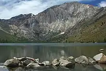
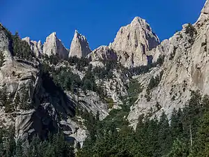 Hikers can access Mount Whitney, highest point in the contiguous United States, through the Inyo National Forest | |
 Map of the United States  Inyo National Forest (the United States) | |
| Location | Eastern Sierra Nevada Range |
| Nearest city | Bishop, California |
| Coordinates | 37°50′N 118°59.5′W[1] |
| Area | 1,903,381 acres (7,702.71 km2)[2] |
| Established | May 25, 1907[3] |
| Governing body | USDA / U.S. Forest Service |
| Website | Inyo National Forest |
Geography
The forest covers 1,903,381 acres (2,974 sq mi; 7,703 km2) and includes nine designated wilderness areas which protect over 800,000 acres (1,200 sq mi; 3,200 km2).[5] Most of the forest is in California, but it includes about 60,700 acres (95 sq mi; 246 km2) in western Nevada.[6] It stretches from the eastern side of Yosemite to south of Sequoia National Park. Geographically it is split in two, one on each side of the Long Valley Caldera and Owens Valley.
The John Muir Wilderness is a part of the Inyo National Forest and abuts Sequoia and Kings Canyon National Park along the crest of the Sierra. The northern part of the Inyo National Forest is preserved as a part of the Ansel Adams Wilderness area, which borders Yosemite National Park. Together, the wilderness areas and parks form one contiguous area of protected wilderness of more than 1.5 million acres (6,100 km2).
The Inyo National Forest was named after Inyo County, California, in which much of the forest resides. The name "Inyo" comes from a Native American word meaning "dwelling place of the great spirit".[7]
The forest spans parts of Inyo, Mono, Tulare, Fresno and Madera counties in California, and Esmeralda and Mineral counties in Nevada.
The forest's headquarters are in Bishop, California, with ranger district offices in Bishop, Lee Vining, Lone Pine, and Mammoth Lakes.[8] The forest was established on May 25, 1907. On July 1, 1945 land from the former Mono National Forest was added.[9]
Wilderness areas
There are nine wilderness areas lying within Inyo NF that are part of the National Wilderness Preservation System. Some of these extend into other National Forests, as indicated:
- Ansel Adams Wilderness (mostly in Sierra NF and partly in Devils Postpile NM)[10]
- Boundary Peak Wilderness
- Golden Trout Wilderness (partly in Sequoia National Forest)
- Hoover Wilderness (mostly in Toiyabe NF)
- Inyo Mountains Wilderness
- John Muir Wilderness (mostly in Sierra NF)[11]
- Owens River Headwaters Wilderness
- South Sierra Wilderness (partly in Sequoia NF)
- White Mountains Wilderness
Ecology
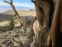
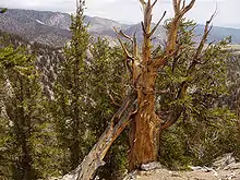
The Inyo National Forest contains the Ancient Bristlecone Pine Forest, which protects specimens of Great Basin bristlecone pines (Pinus longaeva). One of these bristlecone pines is "Methuselah", the second oldest known non-clonal living tree on earth at more than 4,839 years old; the oldest known tree (discovered 2013) also lives in the park.[12]
The forest also harbors an estimated 238,000 acres (963 km2) of old-growth forests.[13] The most abundant trees in these forests are lodgepole pine (Pinus contorta) and Jeffrey pine (Pinus jeffreyi).
Filming location
Inyo National Forest was the site for Ride the High Country (1962) starring Randolph Scott and Joel McCrea, Nevada Smith (1966) starring Steve McQueen, Will Penny (1968) starring Charlton Heston, Joe Kidd (1972) and High Plains Drifter (1973) starring Clint Eastwood, as well as the sci-fi film Star Trek: Insurrection (1998).
Inyo National Forest also served as the filming location for the second half of the second episode in the BBC's Walking with Monsters (2005) documentary series, which was set in Early Permian Germany.
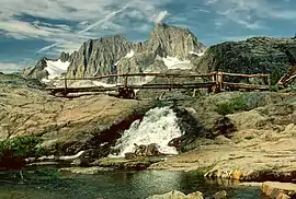
Destinations
Popular within Inyo National Forest are:
See also
References
- "Inyo National Forest". Geographic Names Information System. United States Geological Survey.
- "Land Areas of the National Forest System" (PDF). U.S. Forest Service. January 2012. Retrieved June 26, 2012.
- "The National Forests of the United States" (PDF). ForestHistory.org. Archived from the original (PDF) on October 28, 2012. Retrieved June 26, 2012.
- Reisner, Marc (1993). Cadillac Desert: The American West and its Disappearing Water. New York: Penguin Books. ISBN 0140178244.
- "Inyo National Forest Home Page". U.S. Forest Service. Retrieved 2011-08-22.
- "Inyo National Forest". U.S. National Forest Campground Guide. Retrieved 2011-08-22.
- "Frequently Asked Questions". Inyo National Forest, U.S. Forest Service. Retrieved 2011-08-22.
- "USFS Ranger Districts by State" (PDF). United Four Wheel Drive Associations. Retrieved 2011-08-22.
- Davis, Richard C. (September 29, 2005). "National Forests of the United States" (PDF). Forest History Society. Archived from the original (PDF) on October 28, 2012. Retrieved 2011-08-22.
- "Ansel Adams Wilderness acreage breakdown, Wilderness. net". Archived from the original on 2012-07-01. Retrieved 2012-07-05.
- John Muir Wilderness acreage breakdown, Wilderness.net
- "Rocky Mountain Tree-Ring Research OldList". Retrieved 6 January 2013.
- Warbington, Ralph; Beardsley, Debby (2002). "2002 Estimates of old growth forests on the 18 National Forests of the Pacific Southwest Region". United States Forest Service, Pacific Southwest Region.
External links
| Wikimedia Commons has media related to Inyo National Forest. |
- Inyo National Forest - U.S. Forest Service
- Inyo National Forest map - U.S. Forest Service