Oxkutzcab Municipality
Oxkutzcab Municipality (sometimes spelled as Oxcutzcab) is a municipality, with a municipal seat of the same name in the Mexican state of Yucatán, southeast of Maní, Yucatán, located at 20°18′10″N 89°25′0″W. The name in the Yucatec Maya language means "Place of ramon, tobacco, and honey".
Oxkutzcab | |
|---|---|
Municipality | |
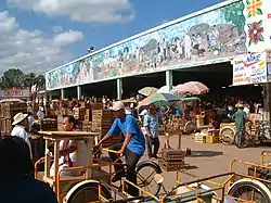 "20 de noviembre" Market in Oxkutzcab | |
 Seal | |
 Location of Oxkutzcab in Yucatán | |
Oxkutzcab Location of Oxkutzcab in Mexico | |
| Coordinates: 20°18′N 89°25′W | |
| Country | |
| State | |
| Government | |
| • Municipal President | José Gualberto Ayora Cámara[1] |
| Area | |
| • Total | 512.23 km2 (197.77 sq mi) |
| [1] | |
| Population | |
| • Total | 27,084 |
| • Density | 53/km2 (140/sq mi) |
| Time zone | UTC-6 (Central Standard Time) |
| • Summer (DST) | UTC-5 (Central Daylight Time) |
| INEGI Code | 056 |
| Major Airport | Merida (Manuel Crescencio Rejón) International Airport |
| IATA Code | MID |
| ICAO Code | MMMD |
According to the 2005 census, Oxkutzcab had a population of 21,341[3] people in the city and 27,084[3] in the entire municipality, predominantly of Maya descent. Henequen, sugar, tobacco, maize, and fruit are grown commercially in the surrounding area. The municipality has an area of 512.23 km2 (197.77 sq mi) and includes a number of smaller towns, the largest of which are Yaxhachén, Xohuayán, Emiliano Zapata, and Xul. Loltun Cave is 5 km (3.1 mi) south of the city.
Oxkutzcab was a town dating back to pre-Columbian times. With the fall of Mayapán in the 1440s, Oxkutzcab became a regional capital ruled by the Xiu family. After the Spanish conquest of Yucatán it was re-established as a Spanish colonial town in 1550; the Maya temples were demolished and a large Franciscan church built.
Oxkutzcab was granted the legal status of a city in the early 19th century. In 1847 the city was sacked in the Caste War of Yucatán. In 1879 the city was linked to the capital of Mérida by railroad.
Each year during the last days of November, the city hosts a "Festival of Oranges". There are two markets of tropical fruits: the "20 de Noviembre" market and "Solidarity" market, better known as "La central".
Climate
| Climate data for Oxcutzcab | |||||||||||||
|---|---|---|---|---|---|---|---|---|---|---|---|---|---|
| Month | Jan | Feb | Mar | Apr | May | Jun | Jul | Aug | Sep | Oct | Nov | Dec | Year |
| Average high °C (°F) | 29.6 (85.3) |
31.3 (88.3) |
33.5 (92.3) |
35.5 (95.9) |
37.0 (98.6) |
35.5 (95.9) |
34.9 (94.8) |
34.8 (94.6) |
34.2 (93.6) |
32.3 (90.1) |
30.9 (87.6) |
29.6 (85.3) |
33.3 (91.9) |
| Average low °C (°F) | 14.8 (58.6) |
15.4 (59.7) |
16.8 (62.2) |
19 (66) |
20.9 (69.6) |
21.6 (70.9) |
21.0 (69.8) |
21.2 (70.2) |
21.3 (70.3) |
20 (68) |
18 (64) |
16.0 (60.8) |
18.8 (65.8) |
| Average precipitation mm (inches) | 28 (1.1) |
20 (0.8) |
38 (1.5) |
46 (1.8) |
86 (3.4) |
150 (6.1) |
150 (6.1) |
190 (7.5) |
200 (7.7) |
110 (4.2) |
51 (2) |
51 (2) |
1,130 (44.3) |
| Source: Weatherbase [4] | |||||||||||||
References
- "Nuestros municipios - Oxcutzcab". Retrieved October 16, 2013.
- "Encyclopedia of the Municipalities of Mexico: Yucatan". Archived from the original on 2008-11-20. Retrieved 2009-11-01.
- Census Results by Locality, 2005 Archived 2011-07-22 at the Wayback Machine INEGI.
- "Weatherbase: Historical Weather for Oxcutzcab, Yucatán". Weatherbase. 2011. Retrieved on November 24, 2011.
External links
- Ayuntamiento de Oxkutzcab Possible future official website
- Oxkutzcab on Yucatan Today
- Oxkutzcab.com (in Spanish)
- Images and articles of Oxkutzcab including panoramic views (in Spanish)
Mérida (capital) | |||||||||||||||
| Topics | 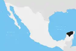 | ||||||||||||||
| Metros | |||||||||||||||
| Larger cities | |||||||||||||||
| Smaller cities |
| ||||||||||||||
| Municipalities |
| ||||||||||||||