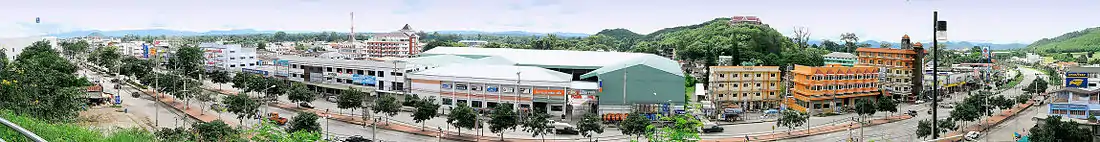
Pak Chong District
Pak Chong District (Thai: ปากช่อง, pronounced [pàːk t͡ɕʰɔ̂ŋ]) is the westernmost district (amphoe) of Nakhon Ratchasima Province, northeastern Thailand.
Pak Chong
ปากช่อง | |
|---|---|
 Lam Takhong Reservoir | |
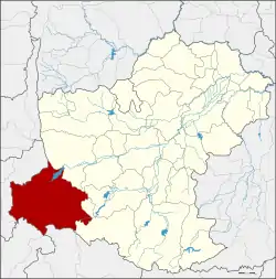 District location in Nakhon Ratchasima Province | |
| Coordinates: 14°42′45″N 101°25′19″E | |
| Country | Thailand |
| Province | Nakhon Ratchasima |
| Seat | Pak Chong |
| Area | |
| • Total | 1,825.2 km2 (704.7 sq mi) |
| Population (2015) | |
| • Total | 193,197 |
| • Density | 100.0/km2 (259/sq mi) |
| Time zone | UTC+7 (ICT) |
| Postal code | 30130, 30320 |
| Geocode | 3021 |
History
In the past this area was a part of Tambon Khanong Phra, Chan Thuek District (which is now Sikhio District).
In 1949 Ban Pak Chong was upgraded to Tambon Pak Chong. It was upgraded to a minor district (king amphoe) effective 1 January 1957, consisting of the four sub-districts Pak Chong, Chanthuek, Klong Dan, and Mu Si.[1] It was upgraded to a full district in July 1958.[2]
Etymology
In the reign of King Chulalongkorn (Rama V) during the construction of the northeastern railway through the area, the Nok Yung and Noi mountains were blasted through to make a cut (chong in Thai) for the railway. The people named the village Pak Chong, meaning "mouth of the channel".
Geography

Pak Chong is the biggest district of Nakhon Ratchasima by area. Neighboring districts are (from the north clockwise) Sikhio, Wang Nam Khiao of Nakhon Ratchasima, Mueang Nakhon Nayok of Nakhon Nayok Province, Prachantakham of Prachinburi Province, and Muak Lek of Saraburi Province.
The district is the gateway to the northeast (Isan) of Thailand from the central region, as the main pass through the Sankamphaeng Range mountainous area is in the southern section of the district. The southern parts of the district are part of Thailand's first and largest national park, Khao Yai. Within the park is the origin of the Lam Takhong, a tributary of the Mun River. The Takhong is the main water resource of Nakhon Ratchasima city.
Economy
The Royal Thai Army's special combat training camp is in Nong Taku, Khanong Phra Subdistrict. It trains five classes of 300 soldiers each per year in the 56-day training course.[3]
Transport
Both the Mittraphap Road or Route 2 as well as the Northeastern railway cross the district.
Railway
Some long-distance trains from Bangkok to Udon Thani or Nong Khai and all trains to Ubon Ratchathani stop at Pak Chong railway station,[4][5] as well as the local trains connecting Kaeng Khoi Junction (east of Saraburi) with Nakhon Ratchasima and beyond.
Administration
Central administration
Pak Chong is divided into 12 sub-districts (tambons), which are further subdivided into 219 administrative villages (mubans).
| No. | Name | Thai | Villages | Pop.[6] |
|---|---|---|---|---|
| 1. | Pak Chong | ปากช่อง | 22 | 44,059 |
| 2. | Klang Dong | กลางดง | 15 | 13,034 |
| 3. | Chanthuek | จันทึก[7] | 22 | 17,246 |
| 4. | Wang Katha | วังกะทะ | 24 | 9,580 |
| 5. | Mu Si | หมูสี | 19 | 12,759 |
| 6. | Nong Sarai | หนองสาหร่าย | 25 | 39,074 |
| 7. | Khanong Phra | ขนงพระ | 15 | 12,537 |
| 8. | Pong Talong | โป่งตาลอง | 13 | 5,217 |
| 9. | Khlong Muang | คลองม่วง | 21 | 10,379 |
| 10. | Nong Nam Daeng | หนองน้ำแดง | 11 | 10,010 |
| 11. | Wang Sai | วังไทร | 18 | 11,435 |
| 12. | Phaya Yen | พญาเย็น | 14 | 7,867 |
Local administration
There is one town (thesaban mueang) in the district:
- Pak Chong (Thai: เทศบาลเมืองปากช่อง) consisting of parts of the sub-districts Pak Chong and Nong Sarai.
There are four sub-district municipalities (thesaban tambons) in the district:
- Klang Dong (Thai: เทศบาลตำบลกลางดง) consisting of parts of sub-districts Klang Dong and Phaya Yen.
- Wang Sai (Thai: เทศบาลตำบลวังไทร) consisting of sub-district Wang Sai.
- Mu Si (Thai: เทศบาลตำบลหมูสี) consisting of sub-district Mu Si.
- Sima Mongkhon (Thai: เทศบาลตำบลสีมามงคล) consisting of parts of sub-district Klang Dong.
There are nine sub-district administrative organizations (SAO) in the district:
- Pak Chong (Thai: องค์การบริหารส่วนตำบลปากช่อง) consisting of parts of sub-district Pak Chong.
- Chanthuek (Thai: องค์การบริหารส่วนตำบลจันทึก) consisting of sub-district Chanthuek.
- Wang Katha (Thai: องค์การบริหารส่วนตำบลวังกะทะ) consisting of sub-district Wang Katha.
- Nong Sarai (Thai: องค์การบริหารส่วนตำบลหนองสาหร่าย) consisting of parts of sub-district Nong Sarai.
- Khanong Phra (Thai: องค์การบริหารส่วนตำบลขนงพระ) consisting of sub-district Khanong Phra.
- Pong Talong (Thai: องค์การบริหารส่วนตำบลโป่งตาลอง) consisting of sub-district Pong Talong.
- Khlong Muang (Thai: องค์การบริหารส่วนตำบลคลองม่วง) consisting of sub-district Khlong Muang.
- Nong Nam Daeng (Thai: องค์การบริหารส่วนตำบลหนองน้ำแดง) consisting of sub-district Nong Nam Daeng.
- Phaya Yen (Thai: องค์การบริหารส่วนตำบลพญาเย็น) consisting of parts of sub-district Phaya Yen.
References
- ประกาศกระทรวงมหาดไทย เรื่อง ยกฐานะตำบลขึ้นเป็นกิ่งอำเภอ (PDF). Royal Gazette (in Thai). 74 (8 ง): 224–225. 1957-01-22.
- พระราชกฤษฎีกาจัดตั้งอำเภอกระสัง อำเภอกระนวน อำเภอบางกอกใหญ่ อำเภอขุนหาร อำเภอพนา อำเภอปากช่อง อำเภอวังเหนือ อำเภอวังชิ้น อำเภอแม่ทา อำเภอหนองหมู อำเภอสระแก้ว อำเภออมก๋อย อำเภอบางซ้าย อำเภอทับสะแก อำเภอบุณฑริก อำเภอลานสะกา อำเภอจอมบึง อำเภอท่ายาง อำเภอสามเงา อำเภอฟากท่า อำเภอบ้านเขว้า อำเภอชานุมาน อำเภอแม่พริก อำเภอท่าสองยาง อำเภอสะเมิง อำเภอหนองแขม อำเภอพระแสง พ.ศ. ๒๕๐๑ (PDF). Royal Gazette (in Thai). 75 (55 ก): 321. July 22, 1958.
- Nanuam, Wassana (17 January 2020). "New army school offers intensive combat courses". Bangkok Post. Retrieved 17 January 2020.
- "NE Outward Train time table" (PDF). State Railway of Thailand.
- "NE Return Train time table" (PDF). State Railway of Thailand.
- "Population statistics 2015" (in Thai). Department of Provincial Administration. Retrieved 2016-03-25.
- พระราชกฤษฎีกาเปลี่ยนนามอำเภอ กิ่งอำเภอ และตำบลบางแห่ง พุทธศักราช ๒๔๘๒ (PDF). Royal Gazette (in Thai). 56 (0 ก): 354–364. April 17, 1939.
| Wikimedia Commons has media related to Pak Chong District. |