Palliser expedition
The British North American Exploring Expedition, commonly called the Palliser expedition, explored and surveyed the open prairies and rugged wilderness of western Canada from 1857 to 1860. The expedition was led by John Palliser, and accompanied by a party of four other men: James Hector, Eugène Bourgeau, Thomas Blakiston and John W. Sullivan.[2] With the support of the British government and the Royal Geographical Society it became an official expedition that provided research and information on the landscape of western Canada. The purpose of the expedition was to gather scientific information on Rupert's Land, including information on the geography, climate, soil, flora and fauna, to discover its capabilities for settlement and transportation.[3] This was the first detailed and scientific survey of the region from Lake Superior to the southern passes of the Rocky Mountains.[4] The expedition provided a better understanding about western Canada and the new observations and knowledge about the landscape was influential in the expansion and development in the western prairies.[5] The information that was gathered impacted the changes in the economy, settlement, transportation, indigenous communities and the expansionist campaign.
_(2211818555).jpg.webp)
Participants
The party consisted of:
- John Palliser, geographer
- James Hector, geologist, naturalist, and surgeon
- Eugène Bourgeau, botanist
- Thomas Blakiston, magnetic observer
- John W. Sullivan, mathematician and sextant observer
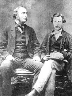 Captain John Palliser and James Hector
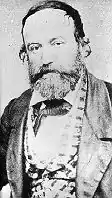 Eugène Bourgeau
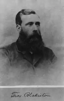 Thomas Wright Blakiston
Views of the West
With little information made publicly known about the western prairies and along the border, the basis of knowledge was made up of speculations.[2] There were two main views of the west at the time; one view which had been the dominant perception leading up to 1856 was of a remote and barren wasteland and remote wilderness that had little prospect for resources and settlement.[5] With the increasing economic changes happening during the mid-19th century, western Canada was being viewed differently in how people envisioned it from the dominant landscapes to the growing potential for different opportunities.[6] This other view was the expansionist view which became popular in 1856 and 1857 and viewed the uncharted territory in the west as a promised land for the possibilities of agricultural prosperity.[5] With the expansionist view and the potential in the land, the western prairies began to also be seen as a place to settle and live as the barren and harsh wilderness was portrayed as a visionary countryside.[6]
Influences on the views of the west
One of the early visionaries of western Canada was Arthur Dobbs, who saw the possibilities of agricultural potential and fertile soil in the mid-18th century.[6] Even with little information or supporting evidence of the land's potential, visions of the west were influential in portraying Canada as an untouched and unsettled wilderness full of opportunity.[6] In the 1850s, the image of the west was influenced more by the British government.[6]
Thomas Devine created the first map of Canada's West in 1857,[7] which showed western Canada and the Hudson's Bay territories.[5] The map described the land and its potential rather than focusing on the physical features of the landscape, and reflected the expansionist views of the west at the time.[5] Expeditions such as Palliser's and Henry Youle Hinds’ were results of the expansionist campaign.[5] With the increasing expeditions out west, exploring the North West became more popular specifically by young British men interested in experiencing the wilderness before being taken over by settlers.[5]
Purpose of the Expedition
The area around the American border and in the western prairies had only been known by the few small Indigenous communities that lived there and the few British fur traders and missionaries, who themselves did not know much about the land.[2] Some of the fur traders and explorers who had been through the area had collected and recorded information and maps; however, this information was not easily accessible to everyone.[2] In order to support the claims and promises of the expansionists that the west held, promising land needed to be found.[5] Palliser and Hind’s expeditions were results of this increasing pressure to learn more about the west from the British government.[6] Both the Canadian and British governments’ interest in western Canada and some of these possible opportunities of the land were responsible for their investment and involvement in further research and expeditions.[5]
The purpose of the expedition was to explore three main areas: the land between Lake Superior and Red River, Red River to the Rocky Mountains, and the land beyond the Rocky Mountains towards the Pacific Ocean along the coast.[2] The route between Lake Superior and Red River connected trading posts and was used by the Hudson's Bay Company for some travel.[2] The route had been used frequently by the company using canoe for trading fur before 1821.[2] While the pass had not been originally part of the expedition, John Ball wanted a neutral perspective of the company's route and determine if it could be used by travelers and for transporting goods as a connecting route between the west and the rest of Canada.[2] Palliser and his party also examined a route called White Fish River to see where the Kaministikwia River connected to the main river and determine if it could be used for transportation purposes or as another possible pass from Canada to the prairies.[2] Palliser had seen waterways being used for transportation in Mississippi and Missouri and saw the potential for connecting Red River to the rest of Canada.[2]
In collecting accurate and detailed information about the land the party was travelling through, they recorded the different landscapes and terrains from bodies of water to forests and mountains.[2]
Forming the Expedition
While some explorers had travelled from Red River out west, many followed routes along the Saskatchewan River that had been used by fur traders.[2] Palliser became more aware of other routes that existed, primarily used by Indigenous communities.[2] In 1848, Palliser met James Sinclair, a Metis explorer with the Hudson's Bay Company, who told Palliser about another pass which was off the route from Red River to the Rocky Mountains and along the border.[2] In 1856, Palliser's interest in the western prairies initiated his plan to explore Western Canada along the American border on an expedition.[2] His interest in some of these alternative routes became an idea for a project that could be used to survey the land and provide information about this region.[2] His project was proposed to the Royal Geographical Society which was involved in coordinating expeditions and worked with the government to help fund some of them, after he was elected as a member of the society on November 24, 1856.[2] Through the Royal Geographical Society, the Expedition Committee approved Palliser's proposal, but recommended that the expedition include the help of scientists who were able to conduct scientific research that could be used to better understand the land as Palliser did not have any formal training.[2] Under the recommendation of John Ball who was the parliamentary under-secretary of state for the colonies during 1856, the government provided funding towards the expedition of £5,000.[2] With the British government's interest in the region that Palliser was proposing to explore, they accepted the proposal and provided funding and support for the expedition.[5] The British government's involvement with the expedition was recognition of the desire and need for development and expansion in the west.[6] While the expedition started out as Palliser's vision of a one-man expedition, exploring the west[2] it became a legitimate expedition that through the connections to influential and authoritative people and organization and support by the Royal Geographical Society and the British government.[5]
John Ball helped organize the group of men to accompany Palliser on the expedition.[2] The group of men that made up this expedition was scientists of various fields.[2] James Hector was one of participants in the expedition, who was a geologist, naturalist and a doctor.[2] Other members of the British party were Eugène Bourgeau who had made many contributions in botanical work, Thomas Wright Blakiston, a magnetical observer, and John W. Sullivan, who was a mathematician and sextant observer, was the secretary for the expedition and responsible for astronomical observations.[2]
Expedition Routes
1857
In May 1857, Palliser and the group of men began the expedition.[2] They sailed from Sault Ste Marie by steamship across Lake Superior and Lake Huron.[2] They continued by canoes and by June 12 they had almost reached Isle Royale and continued through Thunder Bay, across the Kaministikwia River and into Fort William, the starting point of the routes they had set out to explore; the first stretch of land was between Lake Superior and Red River.[2] The expedition continued with horses and carts, with supplies provided by the Hudson's Bay Company.[8] At Red River Palliser employed a number of Metis guides to assist on the trip west. These Metis were: John Ferguson, Henry Hallett, Pierre Beauchamp, Samuel Ballendine, George Daniel, Peter Erasmus, Pierre Falcon Jr., Amable Hogue, Donald Matheson, Antoine Morin, John Foulds, John Morrison, Charles Racette, John Ross, John Simpson, Thomas Sinclair, Robert Sinclair, George Taylor, and Joseph Vermette. These guides also acted as interpreters, scouts and armed escorts.[9]
In June 1857, the party explored White Fish River to determine the river connections and potential usage of the water-ways along with the help of three local Ojibwas.[2] They travelled from Thunder Bay up the Kaministikwia River, climbed Mountain Portage, stopped at the Priest's Portage and crossed nine other portages.[2]
They continued via the Red River and across the prairies. They met Charles W. Iddings, an American surveyor, along the United States border. The expedition continued through Turtle Mountain, Fort Ellice, Roche Percée, along the South Saskatchewan River to Fort Carlton, then along the North Saskatchewan River, where they spent the winter of 1857/1858.
1858
In the spring they marched west, and searched for mountain crossings west of modern-day Irricana. Palliser and Sullivan mapped the North Kananaskis Pass and North Kootenay Pass before returning to Fort Edmonton for the winter. Hector crossed the Vermilion Pass and discovered the Kicking Horse Pass. During the winter, Palliser, Captain Arthur Brisco and William Roland Mitchell went south to Rocky Mountain House to meet the Blackfoot and Northern Peigan First Nations.
1859
In 1859, the expedition mapped the confluence of the Red Deer River and South Saskatchewan River, as well as the Cypress Hills, before turning again west. Hector crossed the Rockies through the Howse Pass, and tried unsuccessfully to push through to the Pacific Coast. Palliser and Sullivan crossed the mountains through the North Kootenay Pass and continued down the Kootenay River to Fort Colvile, which by then was on American soil as a result of the Oregon Treaty of 1846 and placement of the boundary at the 49th Parallel.
Sullivan explored the Columbia River and its tributaries as far west as the Okanogan Valley, while Palliser crossed over land to Midway, BC. Unable to find passes to the Pacific north of the 49th Parallel, they reunited with Hector in Fort Colville. From there, they traveled 598 miles downstream on the Columbia River to Fort Vancouver and the Pacific Coast, then north to Fort Victoria. The expedition returned to the East Coast by ship through San Francisco and Panama (where they had to go overland to reach a ship to travel in the Atlantic), then to Montreal. From there, they finally sailed back to Liverpool.
The Role of Science in Expansion
The science that was used in this expedition in the surveying of the land and information that was gathered was significant in the types of agriculture that could be grown and opportunities for settlement and transportation. The expedition collected and filed astronomical, meteorological, geological and magnetic data, described the fauna and flora of the lands crossed, as well as considerations regarding settlement and transportation.[10] The research conducted on the expeditions by Hind and Palliser began to redefine the landscape of western Canada in its topography and the differences in the atmosphere.[5] The party recorded longitude and latitude points, altitudes, chronometer rates, variations of the compass, collected different types of plants, recorded measures of the rivers, and observed the various geographical terrains and characteristics of the landscapes.[2] The measurements were compared to previous information and recording of the land by other explorers and scientists in recent years.[2] They looked at existing agricultural development in the soil and the kinds of vegetation being grown in some regions.[2]
Impact of the Expedition
Expansionist Campaign and the Economy
Two of the main areas that were discovered on the expedition were the stretch of land which is known now as the fertile belt for the prosperous soil between Red River and the Saskatchewan River Valley and the Rockies.[6] The second expanse of land is through the prairies and extends across the American border, and has become known as Palliser's triangle.[6] They reported to the government that this region was too arid for subsistence agriculture, a finding that was overruled by later officials. That was much to the detriment of those who tried to farm there, particularly when homesteading was encouraged by government grants of land[2] From surveying the land, large amounts of fertile land were found which contributed to the change from an economy built around fur-trading to agriculture.[6] The knowledge and plans for western Canada became more clear after Palliser and Hind's expeditions, with the detailed records and observations they were able to create a more accurate representation and understanding of the west.[5] After three years of publishing details of the expedition, Palliser presented his report to the British Parliament in 1863. A comprehensive map of the surveyed areas was published in 1865.[11][5] They concluded that transport through American territory was more feasible. While they found several passes suitable for crossing the Rocky Mountains, they were prevented from proceeding to the Pacific by mountains further west. From this better understanding and supported evidence of promising land and opportunities, work on expanding the west, settlement and connecting the rest of Canada to the west through additions to transportation.[6] One of the passes that that party explored on their expedition was later used for transportation purposes, as the Canadian Pacific Railway had been built through part of it.[12] The opportunities that the land provided became a priority.[5] In connecting the west with the rest of Canada, by 1870 agriculture was becoming the main focus and resource in the western prairies, though trading fur continued to be part of the economy.[13] Palliser and Hind's expeditions and the research they conducted and the information that they contributed led to the western prairies being divided into regions based on the geography, climate, soil and agricultural potential.[5]
Settlement and Indigenous Communities
The transition in the economic sectors from fur trading to agricultural created more development in western Canada, with a growing population of European settlers.[13] The large presence of European settlers in the west made them a large economic power and created conflict with Indigenous communities in the region.[13] The changes in the economy as a result of this expansion were very rapid and had effected the Metis and Indigenous people as they experienced a shift in their economic, political and cultural control over their communities.[13] Within the 1870s, the foundation of the economy in western Canada was broken down with the isolation and separation from the rest of Canada, and systems of power among Indigenous communities.[13] The disappearance of the buffalo led to the Indigenous communities becoming more reliant on European settlers and the government as they lost their main resource of economic dependency and began selling their land and moving on to reserves.[13]
References
- Canada, Wyman Laliberte from Edmonton (2008-01-21), A Section of a General Map of the Routes in British North America Explored by the Expedition Under Captain Palliser (1865), retrieved 2018-03-29
- Spry, Irene M. (1963). The Palliser Expedition: An Account of John Palliser's British North American Exploring Expedition 1857-1860. Toronto: The Macmillan Company of Canada Limited. pp. 1–310. ISBN 978-0770502874.
- The papers of the Palliser expedition, 1857-1860, edited with an introd. and notes by Irene M. Spry. Toronto, Champlain Society, 1968.
- HSMBC Plaque
- Owram, Doug (2007). The Prairie West as Promised Land. Calgary: University of Calgary Press. pp. 3–28. ISBN 978-1552382301.
- Gerald, Friesen (1987). The Canadian prairies : a history (Student ed.). Toronto: University of Toronto Press. ISBN 0802066488. OCLC 806952637.
- politis (2016-03-22). "First map of Canada's West". Canadian Geographic. Retrieved 2018-03-31.
- Dictionary of Canadian Biography Online. "PALLISER, JOHN". Retrieved 2009-11-15.
- Barkwell, Lawrence. https://www.scribd.com/document/87203952/Palliser-Expedition-1857-Metis-Guides
- Our Heritage. "Background on the Palliser Expedition". Archived from the original on 2010-07-03. Retrieved 2009-11-15.
- Spry, I.M. 1968. The Papers of the Palliser Expedition 1857-1860. Introduction and notes by Irene M. Spry. The Champlain Society. Toronto. 694 p. & xix.
- Spry, Irene M. "Palliser Expedition". The Canadian Encyclopedia. Retrieved 2018-03-31.
- 1946-, Norrie, K. H. (Kenneth Harold) (1991). A history of the Canadian economy. Owram, Doug, 1947-. Toronto: Harcourt Brace Jovanovich, Canada. ISBN 0774730870. OCLC 27685513.CS1 maint: numeric names: authors list (link)
Further reading
- Palliser, John (1863). Exploration - British North America: The journals, detailed reports, and observations relative to the exploration, by Captain Palliser, of that portion of British North America, which, in latitude, lies between the British boundary line and the height of land or watershed of the northern or frozen ocean respectively, and in longitude, between the western shore of Lake Superior and the Pacific Ocean during the years 1857, 1858, 1859, and 1860. London: G.E. Eyre and W. Spottiswoode.
- Palliser, John (1860). Further papers relative to the exploration by the expedition under Captain Palliser of that portion of British North America which lies between the northern branch of the River Saskatchewan and the frontier of the United States; and between the Red River and the Rocky Mountains, and thence to the Pacific Ocean. London: G.E. Eyre and W. Spottiswoode.
- Palliser, John (1859). Papers relative to the exploration by Captain Palliser of that portion of British North America which lies between the northern branch of the River Saskatchewan and the frontier of the United States; and between the Red River and Rocky Mountains. London: G.E. Eyre and W. Spottiswoode.
- Palliser, John (1859). Progress of the British North American exploring expedition under the command of Capt. John Palliser, F.R.G.S. London.

_(2211818555).jpg)