Cypress Hills (Canada)
The Cypress Hills are a geographical region of hills in southwestern Saskatchewan and southeastern Alberta, Canada.
| Cypress Hills | |
|---|---|
 The Cypress Hills | |
| Highest point | |
| Elevation | 1,468 m (4,816 ft) |
| Coordinates | 49°37′48″N 110°21′34″W |
| Geography | |
 Cypress Hills Cypress Hills location in Western Canada | |
| Country | Canada |
| Provinces | Alberta and Saskatchewan |
The highest point in the Cypress Hills is at Head of the Mountain in Alberta at 1,466 metres (4,810 ft). The highest point in Saskatchewan is 1,392 m (4,567 ft), in a farmer's field in the Cypress Hills, at 49°33′N 109°59′W.[1][2]
Name
The Cypress Hills have been known by a wide number of native and European names throughout their history. An 1882 Blackfoot–English dictionary written by C. M. Lanning provided the Blackfoot name I-kim-e-kooy, which translates as "striped earth" or "earth over earth". The Cree name, in use at the same time, is manâtakâw, (spelled in a variety of anglicized forms including "Mun-a-tuh-gow"), sometimes said to mean "beautiful upland" but more accurately referring to "an area to be respected, protected, taken care of and/or taken care with". The Assiniboine name is wazíȟe.[3] The Gros Ventre name is θáaciih "pine trees".[4] Early Métis hunters, who spoke a variation of French, called the hills les montagnes des Cyprès, in reference to the abundance of jack pine trees. In the Canadian French spoken by the Métis, the jack pine is called cyprès,[5] although it is not a true cypress tree. The English translation is Cypress Hills.[6]
Geology and geomorphology
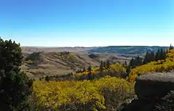
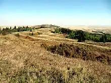
The Cypress Hills reach a maximum elevation of 1,466 metres (4,810 ft), rising about 600 m (1970 ft) above the surrounding plains. They are the remnant of a more widespread plateau, most of which has been removed by erosion. The plateau is capped by the resistant conglomerate and sandstone beds of the Cypress Hills Formation. That formation were deposited by rivers that flowed from the mountains of southwestern Alberta and northwestern Montana during late Eocene to middle Miocene time, and it known for its wealth of vertebrate fossils.[7][8]
During the Pleistocene, the top of the Cypress Hills was not overridden by the Laurentide Ice Sheet and remained unglaciated. As the ice sheet paused periodically during its final retreat, a series of morainal ridges of glacial till built up around the hills. Rivers of meltwater cut large channels through the area as the retreat continued, and smaller streams carved coulees and areas of badlands.[9][10][11]
Today the Cypress Hills are part of a major drainage divide that separates rivers that drain south to the Gulf of Mexico via the Missouri River system from those that drain to northeast to Hudson Bay via the Nelson River system.[9] At the Dividing Springs Ranch northwest of Eastend, Saskatchewan, the water from a spring goes both south to Gulf of Mexico and northeast to Hudson Bay.[12]
Ecology
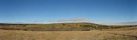
Due to their higher elevation, the upper slopes and summit of the Cypress Hills experience cooler temperatures and greater rainfall than the surrounding semi-arid plains,[13] and they support a flora and fauna that is much like that of the mountains south of the United States-Canada border in Montana and Wyoming.[14]
Flora
The north-facing slopes and some of the valleys host forests of aspen, lodgepole pine, and white spruce. The remainder of the area is covered by mixed grass prairie, with fescue prairie in higher areas. Wildflowers include prairie crocus, three-flowered avens, lupine, blue bells, and prairie rose.[13][14][15] There are fourteen species of orchids, including the Venus's slipper orchid and the striped coralroot orchid, which are found primarily in wooded areas and along the banks of springs and streams.[13]
Fauna
Small mammals of the area include a wide variety of rodents, as well as shrews, bats, jackrabbits, skunks, mink, weasels, foxes, bobcats, Canada lynx, and others. Large mammals include moose, elk, mule deer, white-tailed deer, coyotes, cougars, black bears, and others.[13][14][15][16] There are several species of snakes, including the prairie rattlesnake, as well as lizards and turtles. The many species of birds range from mountain bluebird and greater sage-grouse to the great horned owl and other birds of prey.[13][14][15] Fish in Elkwater Lake and other lakes and streams in the area include walleye, yellow perch, northern pike, several species of trout, and others.
History
Historically the Cypress Hills were a meeting and conflict area for various Native Americans and Aboriginal Canadians (First Nations) including the Cree, Assiniboine, Atsina, Blackfoot, Saulteaux, Sioux, Crow, and others. During the 19th century Métis settled in the hills, hunting and often wintering there. The Cypress Hills Massacre, a key event in Canadian history leading to the creation of the North-West Mounted Police, occurred in the hills when a group of American wolfers from Montana massacred an Assiniboine encampment. Fort Walsh was established to bring law and order to the Canada–US border region.
Interprovincial park
The Cypress Hills Provincial Park in Saskatchewan was established in 1931, and it was extended into Alberta in 1951, and Cypress Hills Interprovincial Park was created in 1989 which joined the parks on either side of the provincial border and also includes Fort Walsh National Historic Site. Cypress Hills Interprovincial Park.[17]
The Saskatchewan side of the park is divided into two blocks, Centre Block which has fully developed yearround tourist facilities and West Block Wilderness area with rustic camping and also where Fort Walsh is also located. The Centre Block is located 30 kilometres south of Maple Creek on Highway 21. The West Block is located 45 kilometres southwest of Maple Creek on Highway 271.
The Alberta portion of the Cypress Hills contains the tourist destination of Elkwater, a community with campground facilities located on the southern shore of Elkwater Lake. The townsite is mainly made up of summer cabins. Elkwater is located about 70 kilometres southeast of Medicine Hat.
Climate
Cypress Hills has a subarctic climate (Dfc) due to its elevation above the surrounding area. Summer days are mild to warm coupled with cool nights, while winters are cold and snowy with annual snowfall averaging 100 inches (255 cm). Precipitation peaks during the month of June, where thunderstorms are common. Chinook winds can raise the temperature 9°F (5°C) in an hour, with it not being uncommon for the temperature to go from 14°F (-10°C) to 68°F (20°C) in a 12 hour period.[18] The highest single day snowfall is 23.6 inches (60 cm) and occurred on May 15th, 1999. The highest snow depth recorded is 31.5 inches (80 cm) and occurred on February 28th, 1994. The highest temperature recorded is 104.9°F (40.5°C) and occurred on May 29th, 1988. The lowest temperature recorded is -44.5°F (-42.5°C) and occurred on January 13th, 2005.[19]
| Climate data for Cypress Hills (1196m) | |||||||||||||
|---|---|---|---|---|---|---|---|---|---|---|---|---|---|
| Month | Jan | Feb | Mar | Apr | May | Jun | Jul | Aug | Sep | Oct | Nov | Dec | Year |
| Record high °C (°F) | 19.0 (66.2) |
18.0 (64.4) |
19.0 (66.2) |
26.0 (78.8) |
40.5 (104.9) |
34.0 (93.2) |
34.5 (94.1) |
34.5 (94.1) |
32.0 (89.6) |
28.0 (82.4) |
21.0 (69.8) |
15.0 (59.0) |
40.5 (104.9) |
| Average high °C (°F) | −3.0 (26.6) |
−1.4 (29.5) |
2.4 (36.3) |
9.8 (49.6) |
15.2 (59.4) |
19.1 (66.4) |
23.2 (73.8) |
22.8 (73.0) |
16.6 (61.9) |
10.1 (50.2) |
1.7 (35.1) |
−2.3 (27.9) |
9.5 (49.1) |
| Daily mean °C (°F) | −9 (16) |
−7.2 (19.0) |
−2.9 (26.8) |
3.5 (38.3) |
8.7 (47.7) |
12.7 (54.9) |
15.9 (60.6) |
15.3 (59.5) |
9.6 (49.3) |
4.0 (39.2) |
−3.5 (25.7) |
−8.0 (17.6) |
3.3 (37.9) |
| Average low °C (°F) | −15.0 (5.0) |
−13.0 (8.6) |
−8.2 (17.2) |
−2.9 (26.8) |
2.1 (35.8) |
6.3 (43.3) |
8.6 (47.5) |
7.6 (45.7) |
2.7 (36.9) |
−2.2 (28.0) |
−8.6 (16.5) |
−13.7 (7.3) |
−3.0 (26.6) |
| Record low °C (°F) | −42.5 (−44.5) |
−40.0 (−40.0) |
−35.5 (−31.9) |
−26.5 (−15.7) |
−11.5 (11.3) |
−3.5 (25.7) |
0.0 (32.0) |
−4.0 (24.8) |
−10.0 (14.0) |
−28.5 (−19.3) |
−39.0 (−38.2) |
−41.5 (−42.7) |
−42.5 (−44.5) |
| Average precipitation mm (inches) | 33.3 (1.31) |
31.0 (1.22) |
43.3 (1.70) |
41.4 (1.63) |
74.0 (2.91) |
103.3 (4.07) |
59.7 (2.35) |
47.8 (1.88) |
58.9 (2.32) |
36.8 (1.45) |
32.8 (1.29) |
38.3 (1.51) |
600.6 (23.64) |
| Source: Environment Canada[20] | |||||||||||||
See also
References
- "Table 15.3 Selected principal heights, by province and territory". Statistics Canada. Retrieved 10 May 2014.
- Kerslake, Danny (5 July 2017). "Mystery of Sask.'s nameless highest point solved by podcast". CBC News. Retrieved 5 March 2018.
- "AISRI Dictionary Database Search--prototype version. Assiniboine". American Indian Studies Research Institute. Retrieved 7 July 2012.
- Cowell, A.; Taylor, A.; Brockie, T. "Gros Ventre ethnogeography and place names: A diachronic perspective". Anthropological Linguistics. 58 (2): 132–170. doi:10.1353/anl.2016.0025.
- forêts, Gouvernement du Canada, Ressources naturelles Canada, Service canadien des. "Pin gris". aimfc.rncan.gc.ca.
- Johnston, Alex (1987). Plants and the Blackfoot. Lethbridge: Lethbridge Historical Society. p. 6. ISBN 978-0919224728.
- Leckie, D.A. and Cheel, R.J. 1989. The Cypress Hills Formation – A semi-arid braid plain deposit resulting from intrusive uplift. Canadian Journal of Earth Sciences, vol. 26, p. 1918-1931.
- Lerbekmo, J.F. 2000. "Geology of the Alberta Cypress Hills. Edmonton Geological Society, 2000 Fall Field Trip Guide" (PDF). Edmonton Geological Society. Retrieved 5 September 2020.
- Broscoe, A.J. 1965. The geomorphology of the Cypress Hills–Milk River Canyon area, Alberta. Alberta Society of Petroleum Geologists, 15th Annual Field Trip Guidebook, p. 74-84.
- Westgate, J.A. 1968. Surficial geology of the Foremost – Cypress Hills area, Alberta. Research Council of Alberta, Bulletin 22.
- Rutter, N. 2000. "Notes on the Quaternary geology. Edmonton Geological Society, 2000 Fall Field Trip Guide" (PDF). Edmonton Geological Society. Retrieved 5 September 2020.
- "Eastend Auto Tour #3" (PDF). Town of Eastend, Saskatchewan. Retrieved 6 January 2020.
- Halladay, I.R. 1965. A general survey of the natural history. Alberta Society of Petroleum Geologists, 15th Annual Field Trip Guidebook, Part 1, Cypress Hills plateau, p. 37-54.
- McCorquedale, B. 1965. Some particular aspects of the biota of the Cypress Hills. Alberta Society of Petroleum Geologists, 15th Annual Field Trip Guidebook, Part 1, Cypress Hills plateau, p. 55-65.
- Anonymous. "Cypress Hills Provincial Park, Natural Environment". Alberta Parks. Retrieved 7 September 2020.
- Saskatchewan Department of Natural Resources, Conservation Information Service (1961). Mammals of Cypress Hills Provincial Park. Regina: Government of Saskatchewan. pp. 4–6.
- "Cypress Hills Interprovincial Park" (PDF). Government of Saskatchewan. Archived from the original (PDF) on 13 March 2006.
- "Cypress Hills Info". www.cypresshills.com. Retrieved 8 June 2020.
- Canada, Environment and Climate Change (25 September 2013). "Canadian Climate Normals 1981-2010 Station Data - Climate - Environment and Climate Change Canada". climate.weather.gc.ca. Retrieved 8 June 2020.
- "Canadian Climate Normals 1981–2010". Retrieved 7 April 2020.
| Physiographic sub-regions |
| ||||||
|---|---|---|---|---|---|---|---|
| Physical features | |||||||
| Ecozones | |||||||
| Parks and protected areas |
| ||||||
| Historic regions | |||||||
| Aboriginal peoples |
| ||||||
| |||||||