Pamir-Alay
The Pamir-Alay (also Pamiro-Alay, Russian: Памиро-Алай) is a mountain system in Tajikistan, Kyrgyzstan and Uzbekistan, encompassing four main mountain ranges extending west from the Tian Shan Mountains, and located north of the main range of Pamir. They are variously considered part of the Tian Shan,[1] of the Pamir,[2] or a separate mountain system.[3] The term "Pamiro-Alay" is also used to refer to the mountain region encompassing the Pamir, the Pamir-Alay proper (then referred to as "Gissaro-Alay") and the Tajik Depression.[4][5]
| Pamir-Alay Памиро-Алай | |
|---|---|
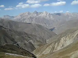 View of the Zarafshan Range near the Anzob Pass | |
| Highest point | |
| Peak | Pik Skalisty |
| Elevation | 5,621 m (18,442 ft) |
| Coordinates | 39°30′N 71°0′E |
| Dimensions | |
| Length | 900 km (560 mi) E/W |
| Width | 150 km (93 mi) N/S |
| Geography | |
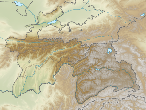 Location in Tajikistan | |
| Country | Tajikistan |
| Parent range | Pamir Mountains |
The Pamir-Alay stretches between the valleys of the rivers Syr Darya (Fergana Valley) to its north and Vakhsh to its south.[2] Its highest summit is Pik Skalisty (Russian: пик Скалистый, "rocky peak"), 5621 m, in the Turkestan Range.[6] The Pamir-Alay is about 900 km long in west–east direction, and up to 150 km wide in the Western part.[5]
Main subranges
The Pamir-Alay is subdivided into the following mountain ranges:[1]
- Turkestan Range (5,621 m)
- Alay Range (5,544 m)
- Zarafshan Range (5,489 m), including Fann Mountains
- Gissar Range (4,643 m), including Köýtendag Range
References
- V.S. Burtman (2000). "Cenozoic crustal shortening between the Pamir and Tien Shan and a reconstruction of the Pamir–Tien Shan transition zone for the Cretaceous and Palaeogene" (PDF). Tectonophysics. 319: 69–92.
- Irina Merzlyakova (2002). "16 The Mountains of Central Asia and Kazakhstan". The Physical Geography of Northern Eurasia. pp. 377–402. ISBN 978-0-19-823384-8.
- Magdalena Opała-Owczarek; Tadeusz Niedźwiedź (2019). "Last 1100 yr of precipitation variability in western central Asia as revealed by tree-ring data from the Pamir-Alay". Quaternary Research. 91: 81–95.
- Памиро-Алай, Great Soviet Encyclopedia
- Гиссаро-Алай, Great Soviet Encyclopedia
- Soviet Union military map 1:500.000 J-42-Б
External links
 Media related to Pamiro-Alay Mountains at Wikimedia Commons