Panare District
Panare (Thai: ปะนาเระ, pronounced [pā.nāː.réʔ]) is a district (amphoe) in Pattani Province, southern Thailand.
Panare
ปะนาเระ | |
|---|---|
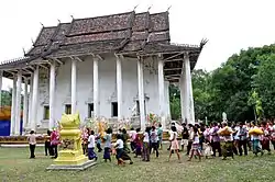 Wat Thep Nimit | |
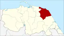 District location in Pattani Province | |
| Coordinates: 6°51′36″N 101°29′29″E | |
| Country | Thailand |
| Province | Pattani |
| Area | |
| • Total | 144.1 km2 (55.6 sq mi) |
| Population (2008) | |
| • Total | 43,131 |
| • Density | 299.0/km2 (774/sq mi) |
| Time zone | UTC+7 (ICT) |
| Postal code | 94130 |
| Geocode | 9404 |
History
The name "Panare" comes from Pattani Malay language. Pata means pantai in Standard Malay meaning 'beach', tare means 'otter trawl'. Thus Pata Tare means 'a beach for drying otter trawls in the air'. With time the pronunciation changed to Panare.
Geography
Neighboring districts are (from the south clockwise) Sai Buri, Mayo, and Yaring. To the north and east is the Gulf of Thailand.
Administration
The district is divided into 10 sub-districts (tambons), which are further subdivided into 52 villages (mubans). Panare is a sub-district municipality (thesaban tambon) which covers most of tambon Panare. There are a further 10 tambon administrative organizations (TAO).
| No. | Name | Thai | Villages | Pop.[1] |
|---|---|---|---|---|
| 1. | Panare | ปะนาเระ | 5 | 9,290 |
| 2. | Tha Kham | ท่าข้าม | 4 | 2,093 |
| 3. | Ban Nok | บ้านนอก | 6 | 4,079 |
| 4. | Don | ดอน | 6 | 3,601 |
| 5. | Khuan | ควน | 5 | 2,437 |
| 6. | Tha Nam | ท่าน้ำ | 5 | 4,249 |
| 7. | Khok Krabue | คอกกระบือ | 4 | 1,866 |
| 8. | Pho Ming | พ่อมิ่ง | 4 | 2,844 |
| 9. | Ban Klang | บ้านกลาง | 9 | 7,146 |
| 10. | Ban Nam Bo | บ้านน้ำบ่อ | 4 | 5,526 |
Economy
Ban Klang Subdistrict is home to the Chao Lay School (Sea Gypsy School of Fishery), an institution that teaches sustainable fishing and has spurred the rejuvenation of Pattani's fisheries industry, horse crabs in particular.[2]
Gallery
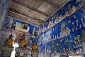 Paintings at Wat Thep Nimit, Ban Klang
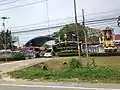 Panare hospital, Tha Kham
.jpg.webp) Ban Klang
Ban Klang.jpg.webp) Countryside, Ban Klang
Countryside, Ban Klang.jpg.webp) Paddy fields and a coconut plantation
Paddy fields and a coconut plantation
References
- "Population statistics 2008". Department of Provincial Administration. Archived from the original on 2009-08-20. Retrieved 2009-11-05.
- Kongrut, Anchalee (2 September 2019). "From Pattani seas to Bangkok plates". Bangkok Post. Retrieved 7 September 2019.
External links
- amphoe.com (Thai)