Panjkora River
The Panjkora River (Urdu: دریائے پنجکوڑہ) is the main river in the Panjkora River Basin which is a part of the larger Swat river basin located in the Khyber Pakhtunkhwa province in the northwest of Pakistan. Panjkora river is generally characterized by steep slopes on either side of the river with a large catchment area. This makes the area a large flood zone with many massive floods occurring. Most notably a flood in 2010 swept through the river resulting in loss of life and large amounts of destruction to ecosystems and infrastructure. Other impacts within the river have been seen with pollution beginning to take a toll and fish stocks dropping and huge economic damage is done every year when floods damage the land surrounding the river.
| Panjkora دریائے پنجکوڑہ | |
|---|---|
 | |
| Location | |
| Country | Pakistan |
| province | Khyber Pakhtunkhwa |
| Region | Upper Dir |
| Physical characteristics | |
| Source | Hindu Kush Mountains |
| • elevation | 3,600 m (11,800 ft) |
| Mouth | Swat River |
• location | Chakdara |
| Length | 220 km (140 mi) |
| Basin features | |
| Tributaries | |
| • left | Ushirai Khwar, Niag Khwar |
| • right | Baraul Khwar, Jandol Khwar |
Geography
The Panjkora river is the main river in the Panjkora River Basin which is a part of the larger Swat River Basin located in the Khyber Pakhtunkhwa province in the northwest of Pakistan. Main tributaries of the Panjkora river are Rivers Dir, Barawal, Kohistan and Usherai.[1] The flow of water occurs year-round, during the monsoon season (June- September) the water levels drastically rise. Large amounts of water can be found during this time in the Panjkora river with greater amounts at the mouths of the tributaries. This water flow is very powerful causing floods throughout the region.[2]
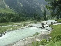
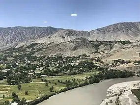
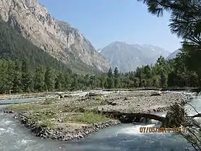
The Panjkora river is located at coordinates (Latitude: 34.6667 Longitude: 71.7667). The river is characterised by steep mountain slopes at the beginning, these act as a funnel trapping the water. Towards the end the river starts to widen, and the flood plain begins to sprawl.[1] The lower flood plains are the main agricultural land used by farmers due to the increased nutrient content in the soil.
Pollution and Environmental Concerns
Bioaccumulation is the major environmental concern currently occurring in the river Panjkora. Bioaccumulation occurs when a species absorbs substances faster than it expels them. This often has increased effects on predators higher up the food chain which can affect humans who digest these organisms. Panjkora river faces increases in toxic metal accumulation in fish species.[3] Metal content found in fish increases the closer you move to the mouth of the river Panjkora.[4] The metal content occurs because of agricultural practices and sewage dumping in the river.[3] Agriculture while being the major industry supporting people living on the river it does come with its down sides. During the large rainfall events huge amounts of runoff occurs, dragging with it the soil, animal droppings and fertilisers. This floods the river with large amounts of lead (Pb) and nickel (Ni).[4] Ni very consistently increased the closer towards the mouth of the river. It is thought that the marble industry effluents were another major source of increase in Ni.[4] The contamination of heavy metals has not yet become a serious health issue for the people who survive off the river. Scientist however predict that if not carefully monitored bioaccumulation continues to manifest and accumulate. Potentially causing significant health risks to the environment and human health.[3]
Natural Disasters
The Panjkora basin is a temperamental region that is very dependent on the season. The climate in this region of Pakistan is characterised by large downpours during the monsoon season (June- September) and relatively dry winters.[5] The monsoon seasons have caused many significant and devastating floods in the region. Most notably a flood in 2010 swept through the river resulting in loss of life and large amounts of destruction to ecosystems and infrastructure.[6] These high levels of seasonal rainfall are magnified by the topography of the land surrounding the river. Steep slopes on either side of the river allow for water to runoff into the river quickly and in large volumes. While rainfall in these higher altitudes is generally less, the combination of the huge basins tributaries makes for large volumes of water towards the mouth of the river Panjkora. With river systems floods are generally much more likely to occur in the low-lying areas towards the base of the mountains.[5] Panjkora basin has 15% of its area classified as highly prone to flooding.[5] These areas that are flood prone are also inhabited making for a deadly mix of people gambling their lives for the rich alluvial farmland. This then continues to run down the river destroying agricultural land, taking lives and causing infrastructure damage.[1]
Socio-Economic Impact
Farmers along the river rely heavily on the rich alluvial soil the flood plains offer.[6] Poor education and management practices mean that the soil often remains fallow for parts of the year. This leads to runoff of the most nutrient dense top 5 cm of soil. This over time depleted soils causing crops to struggle which damages the communities economically. Communities then remain in poverty and struggle to get education and repair infrastructure damaged creating a loop effect.
Cultural Significance
The river has had many empires in control of it, making it a large cultural center for many dynasties. Greeks, Mauryans, Kushans, Hindu Shahi and British are just a few that have made their mark on the previously disputed land.[7] The majority of remnants that are still visible today belong to the Hindu Shahi dynasty with many cultural sites dotted along the river. Only a few studies have investigated the known cultural sites dating to about 9th and 10th centuries.[7] The cultural structures are weathered and mostly all partially destroyed due to the poverty and the weather. This along with lack of interest/ funding makes it very difficult to investigate the cultural history of the river.
Information on the Panjkora river is still very limited with little funding going into researching the history of the region. Often people treat certain aspects as general knowledge and does not need to be written down or they feel comfortable to let the history of the region be left undocumented. This often occurs in developing countries because they either lack the resources or the ability to access necessary information.
Course
The river's headwaters are high in the glaciers of Hindu Kush Mountains. It flows south through the Upper Dir District and the Lower Dir District.
Its confluence with the Swat River is in the Malakand District near totakan. The Swat River is a tributary of the Kabul River, part of the Indus River basin.
Fishing
The Panjkora River is the natural habitat of trout and other freshwater fish sought by anglers. the most common species are cyprinids. snow trout (Schizothorax plagiostomus) is most common game fish in the upper part of River Panjkora at Kumrat Valley. Brown trout and Rainbow trout are exotic species, they were introduced by Britishers in 1928 while snow trout and other cyprinids are native species of River Panjkora.[8]
See also
- Rivers of Khyber Pakhtunkhwa
References
- Mahmood, Shakeel; Khan, Amin ul Haq; Ullah, Saif (1 June 2016). "Assessment of 2010 flash flood causes and associated damages in Dir Valley, Khyber Pakhtunkhwa Pakistan". International Journal of Disaster Risk Reduction. 16: 215–223. doi:10.1016/j.ijdrr.2016.02.009.
- Mahmood, Shakeel; Rahman, Atta-ur (January 2019). "Flash flood susceptibility modeling using geo-morphometric and hydrological approaches in Panjkora Basin, Eastern Hindu Kush, Pakistan". Environmental Earth Sciences. 78 (1): 43. doi:10.1007/s12665-018-8041-y. S2CID 134740564.
- Ahmad, Kabir; Azizullah, Azizullah; Shama, Shama; Khattak, Muhammad Nasir Khan (November 2014). "Determination of heavy metal contents in water, sediments, and fish tissues of Shizothorax plagiostomus in river Panjkora at Lower Dir, Khyber Pakhtunkhwa, Pakistan". Environmental Monitoring and Assessment. 186 (11): 7357–7366. doi:10.1007/s10661-014-3932-1. S2CID 23334879.
- Ali, Hazrat; Khan, Ezzat (January 2019). "Bioaccumulation of Cr, Ni, Cd and Pb in the Economically Important Freshwater Fish Schizothorax plagiostomus from Three Rivers of Malakand Division, Pakistan: Risk Assessment for Human Health". Bulletin of Environmental Contamination and Toxicology. 102 (1): 77–83. doi:10.1007/s00128-018-2500-8. PMID 30456654. S2CID 53873869.
- Ullah, Kashif; Zhang, Jiquan (25 March 2020). "GIS-based flood hazard mapping using relative frequency ratio method: A case study of Panjkora River Basin, eastern Hindu Kush, Pakistan". PLOS ONE. 15 (3): e0229153. Bibcode:2020PLoSO..1529153U. doi:10.1371/journal.pone.0229153. PMC 7094850. PMID 32210424.
- Khattak, Iffat; Rahman, Fazlur; Haq, Faziul (2012). "The Flood Event of July 2010: Socioeconomic Disruptions in Lower Dir District". The Journal of Humanities and Social Sciences. 20 (2): 57–76. ProQuest 1432294038.
- Khan, Ijaz (2017). Exploring the settlement archaeology of the Hindu Shahi dynasty (c. 822 CE to c. 1026 CE) in north-western Pakistan (Thesis).
- Arif Jan, Lecturer in Fisheries, Department of Zoology, Shaheed Benazir Bhutto University, Sheringal Dir Upper, Pakistan