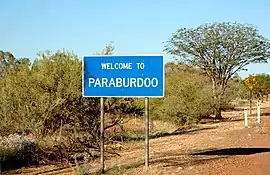
Paraburdoo, Western Australia
Paraburdoo is a mining town in the Pilbara region of Western Australia. The name of the town comes from an Aboriginal word said to mean "feathered meat", which could refer to abundant Little corella or flock pigeons . It could also mean Rock Cave (para means rock and buradoo means hole or cave) to refer to caves nearby. Paraburdoo was developed in the early 1970s to support Hamersley Iron's (now Pilbara Iron) local iron ore mining operations, and was gazetted as a town in 1972.[2] The region is served by Paraburdoo Airport, which is situated 9 kilometres from the town.
| Paraburdoo Western Australia | |||||||||
|---|---|---|---|---|---|---|---|---|---|
 | |||||||||
| Population | 1,380 (2016 census)[1] | ||||||||
| Established | 1960s | ||||||||
| Postcode(s) | 6754 | ||||||||
| Elevation | 424 m (1,391 ft) | ||||||||
| Location | |||||||||
| LGA(s) | Shire of Ashburton | ||||||||
| State electorate(s) | Pilbara | ||||||||
| Federal Division(s) | Durack | ||||||||
| |||||||||
The town provides housing to workers of the three nearby Rio Tinto mines, those being the Channar, Eastern Range and Paraburdoo mine.[3]
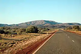
Paraburdoo is located 1,528 kilometres (949 mi) north of Perth, 24 kilometres (15 mi) north of the Tropic of Capricorn, nearly 300 kilometres (190 mi) from the coast, and 424 metres (1,391 ft) above sea level.[4][5]
Most of the town's residents are employed by Pilbara Iron's mining operation and the supporting services. Facilities available for families include daycare, a primary school, and a TAFE. The nearest high school is Tom Price Senior High School in Tom Price, 81 kilometres away. There are also skate parks, swimming pools, tennis courts, and netball, cricket and football fields. Paraburdoo has its own shopping facilities and medical centres.
Climate
Paraburdoo has a hot desert climate (Köppen climate classification BWh). In summer, the days are very hot and the nights are warm. The mean annual maximum temperature is 46.0 °C (114.8 °F), and the all time record high is 47.8 °C (118.0 °F), on 30 December 1997. There is an average of 72.2 days per year where the temperature rises above 40.0 °C (104.0 °F). In winter, the days are warm and the nights are cool. Precipitation is highly variable, coming from storms and tropical cyclones. It falls most often between December and March. Some years, summer months can see no rainfall, and other years over 200 millimetres (7.9 in) of rainfall can come in a single month. Rainfall is sparse from July to November.[4]
| Climate data for Paraburdoo | |||||||||||||
|---|---|---|---|---|---|---|---|---|---|---|---|---|---|
| Month | Jan | Feb | Mar | Apr | May | Jun | Jul | Aug | Sep | Oct | Nov | Dec | Year |
| Record high °C (°F) | 47.5 (117.5) |
47.4 (117.3) |
45.7 (114.3) |
41.6 (106.9) |
37.0 (98.6) |
32.5 (90.5) |
32.5 (90.5) |
36.7 (98.1) |
40.2 (104.4) |
44.7 (112.5) |
44.7 (112.5) |
47.8 (118.0) |
47.8 (118.0) |
| Average high °C (°F) | 40.7 (105.3) |
38.9 (102.0) |
37.0 (98.6) |
33.9 (93.0) |
29.1 (84.4) |
25.2 (77.4) |
25.0 (77.0) |
27.7 (81.9) |
31.5 (88.7) |
36.0 (96.8) |
38.5 (101.3) |
40.6 (105.1) |
33.7 (92.7) |
| Average low °C (°F) | 26.0 (78.8) |
25.1 (77.2) |
23.5 (74.3) |
19.9 (67.8) |
14.7 (58.5) |
11.3 (52.3) |
9.9 (49.8) |
10.9 (51.6) |
13.7 (56.7) |
18.3 (64.9) |
21.5 (70.7) |
24.7 (76.5) |
18.3 (64.9) |
| Record low °C (°F) | 16.2 (61.2) |
18.5 (65.3) |
11.7 (53.1) |
10.5 (50.9) |
5.3 (41.5) |
2.4 (36.3) |
1.3 (34.3) |
2.0 (35.6) |
4.4 (39.9) |
8.2 (46.8) |
13.1 (55.6) |
16.4 (61.5) |
1.3 (34.3) |
| Average rainfall mm (inches) | 58.3 (2.30) |
75.3 (2.96) |
48.5 (1.91) |
24.0 (0.94) |
18.1 (0.71) |
23.1 (0.91) |
13.6 (0.54) |
9.8 (0.39) |
3.3 (0.13) |
4.0 (0.16) |
8.4 (0.33) |
26.1 (1.03) |
317.8 (12.51) |
| Average precipitation days | 7.4 | 7.8 | 6.1 | 3.8 | 2.7 | 3.6 | 2.5 | 1.7 | 0.9 | 1.2 | 2.2 | 4.4 | 44.3 |
| Average afternoon relative humidity (%) (at 15:00) | 19 | 29 | 25 | 26 | 23 | 27 | 26 | 20 | 15 | 12 | 11 | 16 | 21 |
| Source: Bureau of Meteorology[4] Temperatures: 1996–2020; Rain data: 1974–2020; Relative humidity: 1996–2010 | |||||||||||||
References
- Australian Bureau of Statistics (27 June 2017). "Paraburdoo (State Suburb)". 2016 Census QuickStats. Retrieved 29 October 2019.

- Western Australian Land Information Authority. "History of country town names – P". Retrieved 29 October 2019.
- Mining Archived 12 June 2010 at the Wayback Machine Rio Tinto Iron Ore website, accessed: 6 November 2010
- "Climate statistics for Australian locations". Bureau of Meteorology. Retrieved 29 December 2020.
- "Paraburdoo". Australia's Northwest. Retrieved 29 December 2020.